No Photo
Property Record
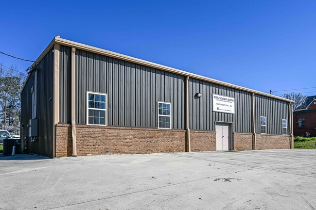
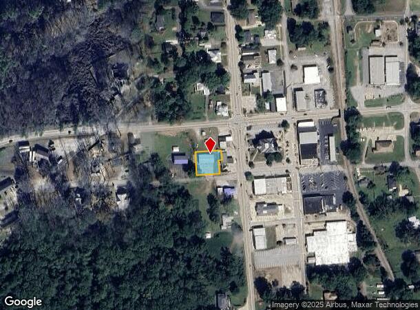
3 Tallapoosa St, Buchanan, GA 30113
NEARBY LISTINGS FOR SALE OR LEASE
-
-
View all Buchanan listings for sale on LoopNet.com
Property Detail
3 Tallapoosa St
BU02-0037
Comm Buchanan Lts
Officebuilding
.282 ACS-BLDG & PARKING LOT
X
Haralson
13143C0165B
Georgia
2024
0.28 AC
2024
Haralson County
010303
Atlanta
2,800 SF
Atlanta-Sandy Springs-Roswell, GA
DEMOGRAPHICS near 3 Tallapoosa St
1 Mile
3 Mile
5 Mile
2024 Total Population
1,173
3,067
6,516
2029 Population
1,303
3,407
7,228
Pop Growth 2024-2029
+ 11.08%
+ 11.09%
+ 10.93%
Average Age
41
41
41
2024 Total Households
457
1,195
2,505
HH Growth 2024-2029
+ 11.16%
+ 11.13%
+ 10.98%
Median Household Inc
$63,355
$64,459
$57,933
Avg Household Size
2.60
2.60
2.60
2024 Avg HH Vehicles
3.00
2.00
2.00
Median Home Value
$160,454
$172,118
$196,192
Median Year Built
1976
1978
1981
Nearby Places
Map Layers
Map Styles
 Street
 Aerial
- Restaurants
- Banks
- Shops
- Fitness
- Groceries
SALE & LEASE HISTORY
LISTING DATE
SALE/LEASE

Oct 06, 2021
For Sale
Mar 13, 2020
For Sale
Nearby Properties
Address
Land Use
TOTAL SIZE
Lot Size
Zoning
Address
Land Use
TOTAL SIZE
Lot Size
Zoning
73,062 SF
27 AC
002
Address
Land Use
TOTAL SIZE
Lot Size
Zoning
189.47 AC
003
Address
Land Use
TOTAL SIZE
Lot Size
Zoning
105,244 SF
55.19 AC
A-1
Address
Land Use
TOTAL SIZE
Lot Size
Zoning
5,311 SF
14.69 AC
I-1
Address
Land Use
TOTAL SIZE
Lot Size
Zoning
4,836 SF
57.50 AC
A-1
Address
Land Use
TOTAL SIZE
Lot Size
Zoning
41.27 AC
I-1
Address
Land Use
TOTAL SIZE
Lot Size
Zoning
8,500 SF
175.50 AC
001
Address
Land Use
TOTAL SIZE
Lot Size
Zoning
726 AC
A-1
Address
Land Use
TOTAL SIZE
Lot Size
Zoning
4,000 SF
3.75 AC
002
Address
Land Use
TOTAL SIZE
Lot Size
Zoning
655 AC
A-1
Address
Land Use
TOTAL SIZE
Lot Size
Zoning
8,993 SF
5 AC
A-1
Address
Land Use
TOTAL SIZE
Lot Size
Zoning
6,000 SF
1.95 AC
C-GB
Address
Land Use
TOTAL SIZE
Lot Size
Zoning
14,252 SF
17.18 AC
001
Address
Land Use
TOTAL SIZE
Lot Size
Zoning
18,600 SF
5 AC
004
Address
Land Use
TOTAL SIZE
Lot Size
Zoning
6,060 SF
0.42 AC
002
Address
Land Use
TOTAL SIZE
Lot Size
Zoning
370.39 AC
A-1
Address
Land Use
TOTAL SIZE
Lot Size
Zoning
4,250 SF
4.31 AC
002
Address
Land Use
TOTAL SIZE
Lot Size
Zoning
28.80 AC
A-1
Address
Land Use
TOTAL SIZE
Lot Size
Zoning
143.77 AC
A-1
Address
Land Use
TOTAL SIZE
Lot Size
Zoning
21,032 SF
2.03 AC
002
Address
Land Use
TOTAL SIZE
Lot Size
Zoning
1,428 SF
3 AC
002
Address
Land Use
TOTAL SIZE
Lot Size
Zoning
8,940 SF
1.48 AC
002
Address
Land Use
TOTAL SIZE
Lot Size
Zoning
285.80 AC
A-1
Address
Land Use
TOTAL SIZE
Lot Size
Zoning
16,900 SF
8.20 AC
003
Address
Land Use
TOTAL SIZE
Lot Size
Zoning
9,824 SF
4.50 AC
R-2
Address
Land Use
TOTAL SIZE
Lot Size
Zoning
2,975 SF
6.21 AC
C-GB
Address
Land Use
TOTAL SIZE
Lot Size
Zoning
4,816 SF
8.24 AC
C-GB
Address
Land Use
TOTAL SIZE
Lot Size
Zoning
139.06 AC
A-1
Address
Land Use
TOTAL SIZE
Lot Size
Zoning
9,579 SF
4 AC
R-3
Address
Land Use
TOTAL SIZE
Lot Size
Zoning
181.63 AC
A-1
The World's #1 Commercial Real Estate Marketplace
Connect with us
© 2025 CoStar Group
The information above has been obtained from sources believed reliable. While we do not doubt its accuracy we have not verified it and make no guarantee, warranty or representation about it. It is your responsibility to independently confirm its accuracy and completeness. Any projections, opinions, assumptions, or estimates used are for example only and do not represent the current or future performance of the property. The value of this transaction to you depends on tax and other factors which should be evaluated by your tax, financial, and legal advisors. You and your advisors should conduct a careful, independent investigation of the property to determine to your satisfaction the suitability of the property for your needs.