Property Record
3 Via Rossi Way, Ballston Spa, NY 12020
NEARBY LISTINGS FOR SALE OR LEASE
Property Detail
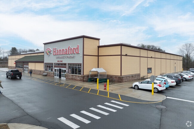
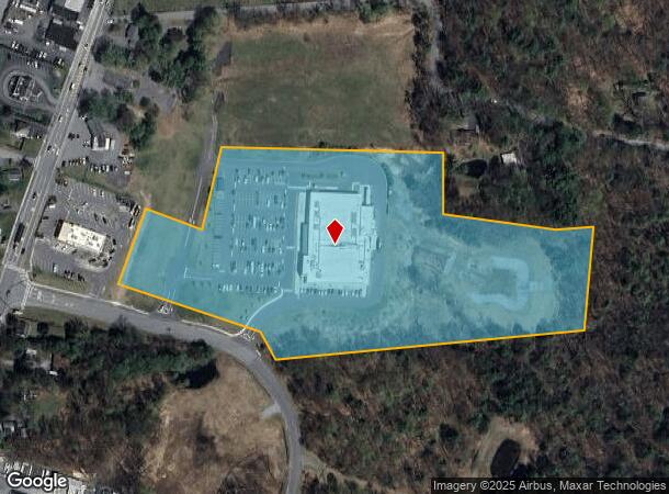
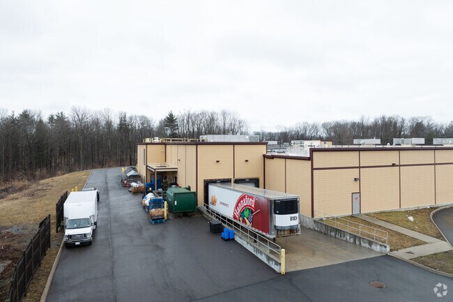
3 Via Rossi Way
Albany-Schenectady-Troy, NY
Saratoga
412089 216.-2-49.1
New York
Supermarket
49.001
2025
10.66 AC
2024
Saratoga County
061701
Albany/Schenectady/Troy
38,793 SF
DEMOGRAPHICS near 3 Via Rossi Way
1 Mile
3 Mile
5 Mile
2024 Total Population
3,710
18,086
47,804
2029 Population
3,931
18,980
49,947
Pop Growth 2024-2029
+ 5.96%
+ 4.94%
+ 4.48%
Average Age
43
42
42
2024 Total Households
1,741
7,708
20,461
HH Growth 2024-2029
+ 6.09%
+ 5.10%
+ 4.45%
Median Household Inc
$70,529
$85,547
$93,423
Avg Household Size
2.00
2.30
2.30
2024 Avg HH Vehicles
2.00
2.00
2.00
Median Home Value
$241,358
$297,212
$287,496
Median Year Built
1966
1986
1988
Nearby Places
Map Layers
Map Styles
 Street
 Aerial
- Restaurants
- Banks
- Shops
- Fitness
- Groceries
PUBLIC TRANSPORTATION
COMMUTER RAIL
DRIVE
WALK
Distance
16 min
7.6 mi
AIRPORT
Albany International
DRIVE
WALK
Distance
Albany International
30 min
21.2 mi
Freight Ports
Albany, NY Port
DRIVE
WALK
Distance
Albany, NY Port
46 min
31.7 mi
SALE & LEASE HISTORY
LISTING DATE
SALE/LEASE

Dec 12, 2022
For Lease
Apr 12, 2024
For Lease
Nearby Properties
Address
Land Use
TOTAL SIZE
Lot Size
Zoning
Address
Land Use
TOTAL SIZE
Lot Size
Zoning
131,567 SF
47.50 AC
Address
Land Use
TOTAL SIZE
Lot Size
Zoning
48,314 SF
117.07 AC
R2
Address
Land Use
TOTAL SIZE
Lot Size
Zoning
141,175 SF
71.20 AC
R1
Address
Land Use
TOTAL SIZE
Lot Size
Zoning
310,018 SF
58.71 AC
PDD
Address
Land Use
TOTAL SIZE
Lot Size
Zoning
128,767 SF
16.51 AC
PDD
Address
Land Use
TOTAL SIZE
Lot Size
Zoning
65,454 SF
12.27 AC
R1
Address
Land Use
TOTAL SIZE
Lot Size
Zoning
40,569 SF
7.90 AC
PDD
Address
Land Use
TOTAL SIZE
Lot Size
Zoning
59,652 SF
PDD
Address
Land Use
TOTAL SIZE
Lot Size
Zoning
12,768 SF
22.12 AC
Address
Land Use
TOTAL SIZE
Lot Size
Zoning
97,640 SF
6.28 AC
Address
Land Use
TOTAL SIZE
Lot Size
Zoning
10,700 SF
36.54 AC
DN-4
Address
Land Use
TOTAL SIZE
Lot Size
Zoning
23,351 SF
134.48 AC
PDD
Address
Land Use
TOTAL SIZE
Lot Size
Zoning
600 SF
50.28 AC
R3
Address
Land Use
TOTAL SIZE
Lot Size
Zoning
58,692 SF
2.06 AC
PDD
Address
Land Use
TOTAL SIZE
Lot Size
Zoning
16,648 SF
7.17 AC
Address
Land Use
TOTAL SIZE
Lot Size
Zoning
61,786 SF
0.78 AC
PDD
Address
Land Use
TOTAL SIZE
Lot Size
Zoning
53,752 SF
9.68 AC
C2&RT67
Address
Land Use
TOTAL SIZE
Lot Size
Zoning
34,352 SF
15.83 AC
Address
Land Use
TOTAL SIZE
Lot Size
Zoning
46,800 SF
5.63 AC
Address
Land Use
TOTAL SIZE
Lot Size
Zoning
71,473 SF
4 AC
Address
Land Use
TOTAL SIZE
Lot Size
Zoning
211,150 SF
23 AC
0
Address
Land Use
TOTAL SIZE
Lot Size
Zoning
31,225 SF
4.38 AC
PDD
Address
Land Use
TOTAL SIZE
Lot Size
Zoning
33,000 SF
2.84 AC
Address
Land Use
TOTAL SIZE
Lot Size
Zoning
79,786 SF
4.93 AC
PDD
Address
Land Use
TOTAL SIZE
Lot Size
Zoning
83,518 SF
4.61 AC
Address
Land Use
TOTAL SIZE
Lot Size
Zoning
8,974 SF
5.08 AC
Address
Land Use
TOTAL SIZE
Lot Size
Zoning
5,032 SF
0.66 AC
CBD
Address
Land Use
TOTAL SIZE
Lot Size
Zoning
6,888 SF
10.36 AC
R-2S
Address
Land Use
TOTAL SIZE
Lot Size
Zoning
31,840 SF
1.72 AC
The World's #1 Commercial Real Estate Marketplace
Connect with us
© 2026 CoStar Group
The information above has been obtained from sources believed reliable. While we do not doubt its accuracy we have not verified it and make no guarantee, warranty or representation about it. It is your responsibility to independently confirm its accuracy and completeness. Any projections, opinions, assumptions, or estimates used are for example only and do not represent the current or future performance of the property. The value of this transaction to you depends on tax and other factors which should be evaluated by your tax, financial, and legal advisors. You and your advisors should conduct a careful, independent investigation of the property to determine to your satisfaction the suitability of the property for your needs.