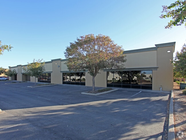
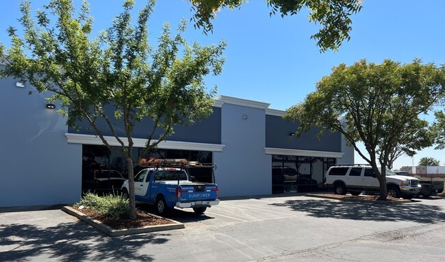
Property Record
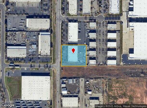
3 Wayne Ct, Sacramento, CA 95829

NEARBY LISTINGS FOR SALE OR LEASE
Property Detail
3 Wayne Ct
Sacramento-Roseville-Folsom, CA
Parcel Map
062-0060-090
PARCEL MAP, LOT 2
Warehouse
Sacramento
X
California
06067C0215H
2
2024
2 AC
2025
Power Inn
009201
Sacramento
28,800 SF
DEMOGRAPHICS near 3 Wayne Ct
1 Mile
3 Mile
5 Mile
2024 Total Population
276
64,639
288,589
2029 Population
264
65,054
290,315
Pop Growth 2024-2029
(4.35%)
+ 0.64%
+ 0.60%
Average Age
42
38
38
2024 Total Households
86
21,166
97,053
HH Growth 2024-2029
(4.65%)
+ 0.59%
+ 0.62%
Median Household Inc
$69,999
$73,473
$70,822
Avg Household Size
2.80
2.90
2.80
2024 Avg HH Vehicles
3.00
2.00
2.00
Median Home Value
$799,999
$388,545
$411,441
Median Year Built
1956
1977
1976
Nearby Places
Map Layers
Map Styles
 Street
 Aerial
- Restaurants
- Banks
- Shops
- Fitness
- Groceries
PUBLIC TRANSPORTATION
COMMUTER RAIL
DRIVE
WALK
Distance
17 min
9.7 mi
AIRPORT
Sacramento International
DRIVE
WALK
Distance
Sacramento International
31 min
21.5 mi
Freight Ports
Port of Stockton
DRIVE
WALK
Distance
Port of Stockton
61 min
49.1 mi
SALE & LEASE HISTORY
LISTING DATE
SALE/LEASE

Jul 06, 2018
For Lease
Aug 28, 2023
For Lease
Nearby Properties
Address
Land Use
TOTAL SIZE
Lot Size
Zoning
Address
Land Use
TOTAL SIZE
Lot Size
Zoning
7,742 SF
12.66 AC
M-1S-SWR
Address
Land Use
TOTAL SIZE
Lot Size
Zoning
2,317,288 SF
220.58 AC
M-2-SPD
Address
Land Use
TOTAL SIZE
Lot Size
Zoning
45.93 AC
M-2S
Address
Land Use
TOTAL SIZE
Lot Size
Zoning
149,566 SF
9.68 AC
M-2S
Address
Land Use
TOTAL SIZE
Lot Size
Zoning
119,380 SF
18.92 AC
M-2S
Address
Land Use
TOTAL SIZE
Lot Size
Zoning
187,080 SF
10.01 AC
SPA M-1
Address
Land Use
TOTAL SIZE
Lot Size
Zoning
40.67 AC
M-2-SPD
Address
Land Use
TOTAL SIZE
Lot Size
Zoning
584,820 SF
29.12 AC
M-2S
Address
Land Use
TOTAL SIZE
Lot Size
Zoning
198,112 SF
19.62 AC
M-1 M-1 (N
Address
Land Use
TOTAL SIZE
Lot Size
Zoning
7.55 AC
SPA
Address
Land Use
TOTAL SIZE
Lot Size
Zoning
281,404 SF
21.43 AC
M-2
Address
Land Use
TOTAL SIZE
Lot Size
Zoning
345,600 SF
14.84 AC
M-1S-SWR
Address
Land Use
TOTAL SIZE
Lot Size
Zoning
164,981 SF
3.95 AC
OB-SWR-PUD
Address
Land Use
TOTAL SIZE
Lot Size
Zoning
261,350 SF
14.41 AC
M-2S
Address
Land Use
TOTAL SIZE
Lot Size
Zoning
319,485 SF
16.35 AC
M-2S
Address
Land Use
TOTAL SIZE
Lot Size
Zoning
135,375 SF
7.40 AC
RD-30
Address
Land Use
TOTAL SIZE
Lot Size
Zoning
158,710 SF
14.02 AC
M-1 (NPA)
Address
Land Use
TOTAL SIZE
Lot Size
Zoning
198,131 SF
13.36 AC
BP
Address
Land Use
TOTAL SIZE
Lot Size
Zoning
138,779 SF
44.77 AC
M-2S
Address
Land Use
TOTAL SIZE
Lot Size
Zoning
120,868 SF
53.03 AC
SPA
Address
Land Use
TOTAL SIZE
Lot Size
Zoning
188,144 SF
16.90 AC
M-2S
Address
Land Use
TOTAL SIZE
Lot Size
Zoning
Address
Land Use
TOTAL SIZE
Lot Size
Zoning
133,620 SF
11.71 AC
C-2-SPD
Address
Land Use
TOTAL SIZE
Lot Size
Zoning
55,344 SF
4.75 AC
M-2S
Address
Land Use
TOTAL SIZE
Lot Size
Zoning
150,652 SF
4.10 AC
OB-SWR-PUD
Address
Land Use
TOTAL SIZE
Lot Size
Zoning
143,004 SF
8.81 AC
M-2S
Address
Land Use
TOTAL SIZE
Lot Size
Zoning
12.04 AC
M-1S-R
Address
Land Use
TOTAL SIZE
Lot Size
Zoning
161,834 SF
15.23 AC
LC
Address
Land Use
TOTAL SIZE
Lot Size
Zoning
5.29 AC
M-2S
Address
Land Use
TOTAL SIZE
Lot Size
Zoning
8,724 SF
101.84 AC
M-2 (SM)
The World's #1 Commercial Real Estate Marketplace
Connect with us
© 2026 CoStar Group
The information above has been obtained from sources believed reliable. While we do not doubt its accuracy we have not verified it and make no guarantee, warranty or representation about it. It is your responsibility to independently confirm its accuracy and completeness. Any projections, opinions, assumptions, or estimates used are for example only and do not represent the current or future performance of the property. The value of this transaction to you depends on tax and other factors which should be evaluated by your tax, financial, and legal advisors. You and your advisors should conduct a careful, independent investigation of the property to determine to your satisfaction the suitability of the property for your needs.