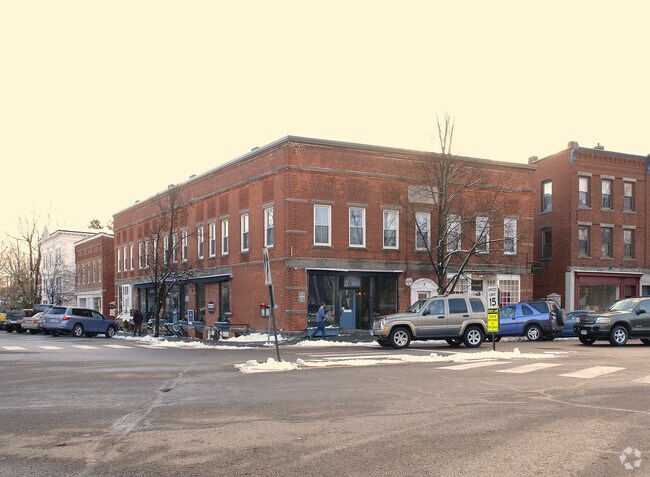
Property Record
3 West St, Litchfield, CT 06759

Property Detail
3 West St
LITC-000206-000047-000017
Nw Hills
Commercialbuilding
Connecticut
HTC
17
2025
0.23 AC
2025
NW Litchfield County
300500
Hartford
11,356 SF
Torrington, CT
NEARBY LISTINGS FOR SALE OR LEASE
-
-
View all Litchfield listings for sale on LoopNet.com
DEMOGRAPHICS near 3 West St
1 mile
3 mile
5 mile
2025 Total Population
2,148
4,661
19,408
2030 Population
2,202
4,737
19,610
Pop Growth 2025-2030
+ 2.51%
+ 1.63%
+ 1.04%
Average Age
46
47
45
2025 Total Households
891
2,000
8,326
HH Growth 2025-2030
+ 2.81%
+ 1.70%
+ 1.08%
Median Household Inc
$97,395
$99,231
$84,152
Avg Household Size
2.10
2.10
2.20
2025 Avg HH Vehicles
2.00
2.00
2.00
Median Home Value
$383,571
$394,478
$316,568
Median Year Built
1956
1961
1959
Nearby Places
Map Layers
Map Styles
 Street
 Aerial
Transit
 Traffic
 Biking
Places
Listings with unknown addresses are not visible on the map
- Restaurants
- Banks
- Shops
- Fitness
- Groceries
PUBLIC TRANSPORTATION
AIRPORT
Bradley International
Drive
Walk
Distance
Bradley International
65 min
39.4 mi
Tweed/New Haven
Drive
Walk
Distance
Tweed/New Haven
71 min
44.1 mi
Freight Ports
Port of New Haven
Drive
Walk
Distance
Port of New Haven
66 min
41.3 mi
SALE & LEASE HISTORY
LISTING DATE
SALE/LEASE

Sep 05, 2024
For Sale
Nearby Properties
Address
Land Use
TOTAL SIZE
Lot Size
Zoning
Address
Land Use
TOTAL SIZE
Lot Size
Zoning
104.86 AC
RR
Address
Land Use
TOTAL SIZE
Lot Size
Zoning
117.77 AC
RR
Address
Land Use
TOTAL SIZE
Lot Size
Zoning
28.27 AC
RR
Address
Land Use
TOTAL SIZE
Lot Size
Zoning
160 AC
RR
Address
Land Use
TOTAL SIZE
Lot Size
Zoning
33 AC
RR
Address
Land Use
TOTAL SIZE
Lot Size
Zoning
58.50 AC
RR
Address
Land Use
TOTAL SIZE
Lot Size
Zoning
36,531 SF
3.35 AC
HR20
Address
Land Use
TOTAL SIZE
Lot Size
Zoning
30.60 AC
HR30
Address
Land Use
TOTAL SIZE
Lot Size
Zoning
74,534 SF
6.01 AC
C202
Address
Land Use
TOTAL SIZE
Lot Size
Zoning
10.92 AC
C202
Address
Land Use
TOTAL SIZE
Lot Size
Zoning
39,585 SF
6.32 AC
GR
Address
Land Use
TOTAL SIZE
Lot Size
Zoning
151.40 AC
RR
Address
Land Use
TOTAL SIZE
Lot Size
Zoning
8.03 AC
C202
Address
Land Use
TOTAL SIZE
Lot Size
Zoning
15,423 SF
0.31 AC
HTC
Address
Land Use
TOTAL SIZE
Lot Size
Zoning
38,604 SF
8.95 AC
BORO 8
Address
Land Use
TOTAL SIZE
Lot Size
Zoning
469.36 AC
RR
Address
Land Use
TOTAL SIZE
Lot Size
Zoning
36.63 AC
RR
Address
Land Use
TOTAL SIZE
Lot Size
Zoning
2.92 AC
HR30
Address
Land Use
TOTAL SIZE
Lot Size
Zoning
0.98 AC
HR30
Address
Land Use
TOTAL SIZE
Lot Size
Zoning
2.83 AC
HR30
Address
Land Use
TOTAL SIZE
Lot Size
Zoning
6,912 SF
0.36 AC
HR30
Address
Land Use
TOTAL SIZE
Lot Size
Zoning
34,687 SF
3.51 AC
C202
Address
Land Use
TOTAL SIZE
Lot Size
Zoning
26,531 SF
10.56 AC
BORO 8
Address
Land Use
TOTAL SIZE
Lot Size
Zoning
1.80 AC
HR30
Address
Land Use
TOTAL SIZE
Lot Size
Zoning
31,917 SF
10.50 AC
C202
Address
Land Use
TOTAL SIZE
Lot Size
Zoning
36,668 SF
2.58 AC
HR20
Address
Land Use
TOTAL SIZE
Lot Size
Zoning
15,876 SF
2.69 AC
BORO 8
Address
Land Use
TOTAL SIZE
Lot Size
Zoning
8.54 AC
RR
Address
Land Use
TOTAL SIZE
Lot Size
Zoning
26 AC
RR
Address
Land Use
TOTAL SIZE
Lot Size
Zoning
6.50 AC
HR30
The World's #1 Commercial Real Estate Marketplace
Connect with us
© 2026 CoStar Group
The information above has been obtained from sources believed reliable. While we do not doubt its accuracy we have not verified it and make no guarantee, warranty or representation about it. It is your responsibility to independently confirm its accuracy and completeness. Any projections, opinions, assumptions, or estimates used are for example only and do not represent the current or future performance of the property. The value of this transaction to you depends on tax and other factors which should be evaluated by your tax, financial, and legal advisors. You and your advisors should conduct a careful, independent investigation of the property to determine to your satisfaction the suitability of the property for your needs.