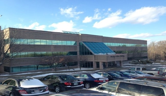
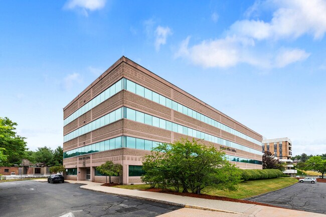
Property Record
3 Woodland Rd, Stoneham, MA 02180

Current Lease Availabilities
NEARBY LISTINGS FOR SALE OR LEASE
Property Detail
3 Woodland Rd
Officecondo
Middlesex
X
Massachusetts
25017C0429F
421b
2025
Saugus/Lynn
2025
Boston
337102
Boston-Cambridge-Newton, MA-NH
3,002 SF
STON-000027-000000-000119B
DEMOGRAPHICS near 3 Woodland Rd
1 Mile
3 Mile
5 Mile
2024 Total Population
6,844
161,281
501,034
2029 Population
6,802
158,093
489,273
Pop Growth 2024-2029
(0.61%)
(1.98%)
(2.35%)
Average Age
44
41
40
2024 Total Households
2,942
63,940
199,758
HH Growth 2024-2029
(0.31%)
(2.01%)
(2.39%)
Median Household Inc
$114,301
$106,341
$103,048
Avg Household Size
2.20
2.40
2.40
2024 Avg HH Vehicles
2.00
2.00
1.00
Median Home Value
$662,500
$702,174
$705,211
Median Year Built
1954
1949
1951
Nearby Places
Map Layers
Map Styles
 Street
 Aerial
- Restaurants
- Banks
- Shops
- Fitness
- Groceries
PUBLIC TRANSPORTATION
COMMUTER RAIL
Wyoming Hill (Haverhill Line - Massachusetts Bay Transportation Authority Commuter Rail (Purple Line))
DRIVE
WALK
Distance
Wyoming Hill (Haverhill Line - Massachusetts Bay Transportation Authority Commuter Rail (Purple Line))
5 min
1.7 mi
Melrose/Cedar Park (Haverhill Line - Massachusetts Bay Transportation Authority Commuter Rail (Purple Line))
DRIVE
WALK
Distance
Melrose/Cedar Park (Haverhill Line - Massachusetts Bay Transportation Authority Commuter Rail (Purple Line))
5 min
1.9 mi
AIRPORT
General Edward Lawrence Logan International
DRIVE
WALK
Distance
General Edward Lawrence Logan International
19 min
10.6 mi
Freight Ports
Port of Boston
DRIVE
WALK
Distance
Port of Boston
20 min
10.3 mi
Nearby Properties
Address
Land Use
TOTAL SIZE
Lot Size
Zoning
Address
Land Use
TOTAL SIZE
Lot Size
Zoning
Address
Land Use
TOTAL SIZE
Lot Size
Zoning
530,113 SF
29.43 AC
Address
Land Use
TOTAL SIZE
Lot Size
Zoning
21,024 SF
18.19 AC
Address
Land Use
TOTAL SIZE
Lot Size
Zoning
14.97 AC
C
Address
Land Use
TOTAL SIZE
Lot Size
Zoning
454,752 SF
6.22 AC
Address
Land Use
TOTAL SIZE
Lot Size
Zoning
Address
Land Use
TOTAL SIZE
Lot Size
Zoning
153,732 SF
12.50 AC
SCI
Address
Land Use
TOTAL SIZE
Lot Size
Zoning
0.47 AC
M
Address
Land Use
TOTAL SIZE
Lot Size
Zoning
70,134 SF
2.25 AC
CB
Address
Land Use
TOTAL SIZE
Lot Size
Zoning
11.72 AC
Address
Land Use
TOTAL SIZE
Lot Size
Zoning
319,472 SF
2.34 AC
CB
Address
Land Use
TOTAL SIZE
Lot Size
Zoning
362,970 SF
8.36 AC
BH
Address
Land Use
TOTAL SIZE
Lot Size
Zoning
214,337 SF
1.42 AC
CB
Address
Land Use
TOTAL SIZE
Lot Size
Zoning
236,853 SF
0.86 AC
CB
Address
Land Use
TOTAL SIZE
Lot Size
Zoning
194,250 SF
2.48 AC
Address
Land Use
TOTAL SIZE
Lot Size
Zoning
720 SF
632 AC
SA8
Address
Land Use
TOTAL SIZE
Lot Size
Zoning
191,050 SF
3.15 AC
Address
Land Use
TOTAL SIZE
Lot Size
Zoning
213,000 SF
2.97 AC
RESA
Address
Land Use
TOTAL SIZE
Lot Size
Zoning
4.58 AC
HB
Address
Land Use
TOTAL SIZE
Lot Size
Zoning
264,580 SF
3.05 AC
CB
Address
Land Use
TOTAL SIZE
Lot Size
Zoning
165,920 SF
Address
Land Use
TOTAL SIZE
Lot Size
Zoning
138,880 SF
4.90 AC
ROD
Address
Land Use
TOTAL SIZE
Lot Size
Zoning
5.63 AC
C
Address
Land Use
TOTAL SIZE
Lot Size
Zoning
8.17 AC
RB
Address
Land Use
TOTAL SIZE
Lot Size
Zoning
9 AC
C/R
Address
Land Use
TOTAL SIZE
Lot Size
Zoning
3,578 SF
11.34 AC
Address
Land Use
TOTAL SIZE
Lot Size
Zoning
63 AC
RESA
Address
Land Use
TOTAL SIZE
Lot Size
Zoning
149,760 SF
3.66 AC
RESA
Address
Land Use
TOTAL SIZE
Lot Size
Zoning
2.44 AC
Address
Land Use
TOTAL SIZE
Lot Size
Zoning
53,415 SF
11.02 AC
SCI
The World's #1 Commercial Real Estate Marketplace
Connect with us
© 2025 CoStar Group
The information above has been obtained from sources believed reliable. While we do not doubt its accuracy we have not verified it and make no guarantee, warranty or representation about it. It is your responsibility to independently confirm its accuracy and completeness. Any projections, opinions, assumptions, or estimates used are for example only and do not represent the current or future performance of the property. The value of this transaction to you depends on tax and other factors which should be evaluated by your tax, financial, and legal advisors. You and your advisors should conduct a careful, independent investigation of the property to determine to your satisfaction the suitability of the property for your needs.