Property Record
30 7Th St E, Saint Paul, MN 55101
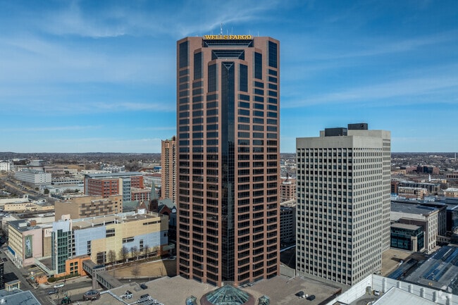

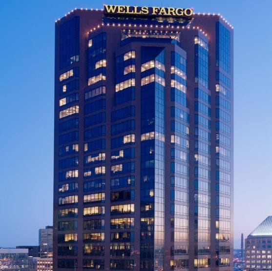

Property Detail
30 7Th St E
Minneapolis-St. Paul-Bloomington, MN-WI
BAZIL AND GUERINS ADDITION VAC ST ACCRUING & THE FOL TRACT; BEG OF ...& GUERINS ADD ALL OF BLK 12
06-28-22-12-0099
Ramsey
Officebuilding
Minnesota
B and X Area of moderate flood hazard, usually the area between the limits of the 100-year and 500-year floods.
1,2
2024
2.66 AC
2025
St Paul CBD
034201
Minneapolis/St Paul
759,622 SF
NEARBY LISTINGS FOR SALE OR LEASE
DEMOGRAPHICS near 30 7Th St E
1 mile
3 mile
5 mile
2025 Total Population
21,383
170,755
363,522
2030 Population
21,764
170,025
362,945
Pop Growth 2025-2030
+ 1.78%
(0.43%)
(0.16%)
Average Age
40
36
38
2025 Total Households
11,615
65,991
142,691
HH Growth 2025-2030
+ 1.74%
(0.36%)
(0.08%)
Median Household Inc
$59,836
$70,364
$74,829
Avg Household Size
1.70
2.40
2.40
2025 Avg HH Vehicles
1.00
2.00
2.00
Median Home Value
$273,408
$271,634
$297,667
Median Year Built
1971
1950
1957
Nearby Places
Map Layers
Map Styles
 Street
 Aerial
Layers
 Traffic
 Biking
Places
Listings with unknown addresses are not visible on the map
- Restaurants
- Banks
- Shops
- Fitness
- Groceries
PUBLIC TRANSPORTATION
TRANSIT/SUBWAY
10Th St Station (METRO Green Line - Metro Transit)
Drive
Walk
Distance
10Th St Station (METRO Green Line - Metro Transit)
1 min
5 min
0.3 mi
Central Station (METRO Green Line - Metro Transit)
Drive
Walk
Distance
Central Station (METRO Green Line - Metro Transit)
1 min
7 min
0.3 mi
Union Depot Crossing (METRO Green Line - Metro Transit)
Drive
Walk
Distance
Union Depot Crossing (METRO Green Line - Metro Transit)
1 min
10 min
0.5 mi
Robert St Station (METRO Green Line - Metro Transit)
Drive
Walk
Distance
Robert St Station (METRO Green Line - Metro Transit)
2 min
11 min
0.6 mi
Union Depot Station (METRO Green Line - Metro Transit)
Drive
Walk
Distance
Union Depot Station (METRO Green Line - Metro Transit)
2 min
12 min
0.6 mi
COMMUTER RAIL
St. Paul-Minneapolis (Empire Builder - Amtrak)
Drive
Walk
Distance
St. Paul-Minneapolis (Empire Builder - Amtrak)
2 min
14 min
0.7 mi
AIRPORT
Minneapolis-St Paul International/Wold-Chamberlain
Drive
Walk
Distance
Minneapolis-St Paul International/Wold-Chamberlain
16 min
9.4 mi
Freight Ports
Port Milwaukee
Drive
Walk
Distance
Port Milwaukee
363 min
329.4 mi
SALE & LEASE HISTORY
LISTING DATE
SALE/LEASE

Sep 25, 2016
For Lease
Sep 24, 2016
For Sale
Sep 24, 2016
For Sale
Nov 09, 2017
For Lease
Jul 26, 2018
For Lease
Aug 30, 2017
For Lease
The World's #1 Commercial Real Estate Marketplace
Connect with us
© 2026 CoStar Group
The information above has been obtained from sources believed reliable. While we do not doubt its accuracy we have not verified it and make no guarantee, warranty or representation about it. It is your responsibility to independently confirm its accuracy and completeness. Any projections, opinions, assumptions, or estimates used are for example only and do not represent the current or future performance of the property. The value of this transaction to you depends on tax and other factors which should be evaluated by your tax, financial, and legal advisors. You and your advisors should conduct a careful, independent investigation of the property to determine to your satisfaction the suitability of the property for your needs.