Property Record
30 Airline Rd, Durham, CT 06422

Save to a Folder
{{folder.Name}}
{{folder.ListingIds.length}} Properties
{{folder.ListingIds.length}} Property
Create a New Folder
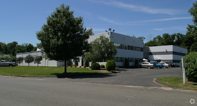
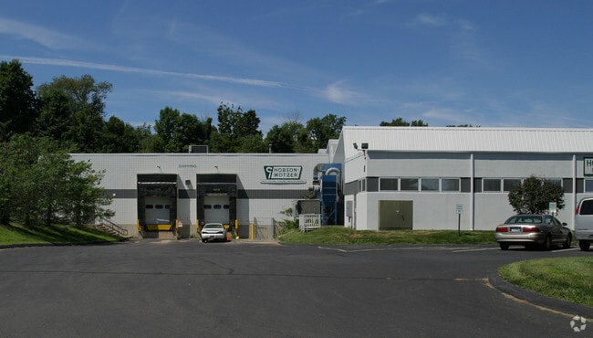
Property Detail
30 Airline Rd
DURH-000122-000200H
Lower Ct River Vly
Industrialgeneral
Connecticut
HEAVY
3.27 AC
B and X Area of moderate flood hazard, usually the area between the limits of the 100-year and 500-year floods.
NW Middlesex/Mid'town
2025
Hartford
2025
Hartford-West Hartford-East Hartford, CT
585100
NEARBY LISTINGS FOR SALE OR LEASE
DEMOGRAPHICS near 30 Airline Rd
1 mile
3 mile
5 mile
2025 Total Population
474
9,342
48,060
2030 Population
470
9,356
48,405
Pop Growth 2025-2030
(0.84%)
+ 0.15%
+ 0.72%
Average Age
43
44
44
2025 Total Households
178
3,578
19,168
HH Growth 2025-2030
(1.12%)
+ 0.20%
+ 0.66%
Median Household Inc
$149,999
$124,904
$106,152
Avg Household Size
2.60
2.60
2.40
2025 Avg HH Vehicles
3.00
3.00
2.00
Median Home Value
$436,170
$415,824
$337,201
Median Year Built
1973
1976
1971
Nearby Places
Map Layers
Map Styles
 Street
 Aerial
Layers
 Traffic
 Biking
Places
Listings with unknown addresses are not visible on the map
- Restaurants
- Banks
- Shops
- Fitness
- Groceries
PUBLIC TRANSPORTATION
COMMUTER RAIL
Wallingford (Hartford Line - CONN DOT)
Drive
Walk
Distance
Wallingford (Hartford Line - CONN DOT)
12 min
6.3 mi
Wallingford Amtrak (Amtrak Hartford Line - Amtrak, Northeast Regional - Amtrak, Valley Flyer - Amtrak)
Drive
Walk
Distance
Wallingford Amtrak (Amtrak Hartford Line - Amtrak, Northeast Regional - Amtrak, Valley Flyer - Amtrak)
12 min
6.5 mi
AIRPORT
Tweed/New Haven
Drive
Walk
Distance
Tweed/New Haven
34 min
21.9 mi
Freight Ports
Port of New Haven
Drive
Walk
Distance
Port of New Haven
29 min
19.6 mi
Nearby Properties
Address
Land Use
TOTAL SIZE
Lot Size
Zoning
Address
Land Use
TOTAL SIZE
Lot Size
Zoning
329,296 SF
35.55 AC
IX
Address
Land Use
TOTAL SIZE
Lot Size
Zoning
339,844 SF
52.43 AC
M-4
Address
Land Use
TOTAL SIZE
Lot Size
Zoning
291,405 SF
104.81 AC
WI
Address
Land Use
TOTAL SIZE
Lot Size
Zoning
187,914 SF
16.13 AC
IX
Address
Land Use
TOTAL SIZE
Lot Size
Zoning
203,692 SF
21.22 AC
IX
Address
Land Use
TOTAL SIZE
Lot Size
Zoning
166,724 SF
21.79 AC
M-2
Address
Land Use
TOTAL SIZE
Lot Size
Zoning
81,496 SF
5.96 AC
WI
Address
Land Use
TOTAL SIZE
Lot Size
Zoning
94,044 SF
5.48 AC
WI
Address
Land Use
TOTAL SIZE
Lot Size
Zoning
20,330 SF
174.02 AC
WI
Address
Land Use
TOTAL SIZE
Lot Size
Zoning
124,940 SF
49.46 AC
FARM -
Address
Land Use
TOTAL SIZE
Lot Size
Zoning
171,057 SF
25.06 AC
M-4
Address
Land Use
TOTAL SIZE
Lot Size
Zoning
98,894 SF
44.82 AC
WI
Address
Land Use
TOTAL SIZE
Lot Size
Zoning
78,477 SF
5 AC
WI
Address
Land Use
TOTAL SIZE
Lot Size
Zoning
81,358 SF
9.64 AC
WI
Address
Land Use
TOTAL SIZE
Lot Size
Zoning
86,171 SF
6.60 AC
WI
Address
Land Use
TOTAL SIZE
Lot Size
Zoning
70,112 SF
9.20 AC
WI
Address
Land Use
TOTAL SIZE
Lot Size
Zoning
69,179 SF
15.90 AC
WI
Address
Land Use
TOTAL SIZE
Lot Size
Zoning
81,200 SF
17.14 AC
IX
Address
Land Use
TOTAL SIZE
Lot Size
Zoning
82,685 SF
10.32 AC
IX
Address
Land Use
TOTAL SIZE
Lot Size
Zoning
54,044 SF
3.08 AC
WI
Address
Land Use
TOTAL SIZE
Lot Size
Zoning
168,702 SF
48.80 AC
RDD
Address
Land Use
TOTAL SIZE
Lot Size
Zoning
20.60 AC
RDD
Address
Land Use
TOTAL SIZE
Lot Size
Zoning
52,668 SF
14.02 AC
WI
Address
Land Use
TOTAL SIZE
Lot Size
Zoning
62,464 SF
9.28 AC
IX
Address
Land Use
TOTAL SIZE
Lot Size
Zoning
40,938 SF
14.53 AC
FARM -
Address
Land Use
TOTAL SIZE
Lot Size
Zoning
36,106 SF
14.73 AC
MD
Address
Land Use
TOTAL SIZE
Lot Size
Zoning
32.52 AC
AG2
Address
Land Use
TOTAL SIZE
Lot Size
Zoning
62,967 SF
9.40 AC
MAIN S
Address
Land Use
TOTAL SIZE
Lot Size
Zoning
54,400 SF
4.85 AC
WI
Address
Land Use
TOTAL SIZE
Lot Size
Zoning
41,976 SF
2.97 AC
IX
The World's #1 Commercial Real Estate Marketplace
Connect with us
© 2026 CoStar Group
The information above has been obtained from sources believed reliable. While we do not doubt its accuracy we have not verified it and make no guarantee, warranty or representation about it. It is your responsibility to independently confirm its accuracy and completeness. Any projections, opinions, assumptions, or estimates used are for example only and do not represent the current or future performance of the property. The value of this transaction to you depends on tax and other factors which should be evaluated by your tax, financial, and legal advisors. You and your advisors should conduct a careful, independent investigation of the property to determine to your satisfaction the suitability of the property for your needs.