Property Record
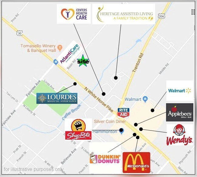
30 Basin Rd, Hammonton, NJ 08037
NEARBY LISTINGS FOR SALE OR LEASE
-
-
No Photo
-
View all Hammonton listings for sale on LoopNet.com
Property Detail
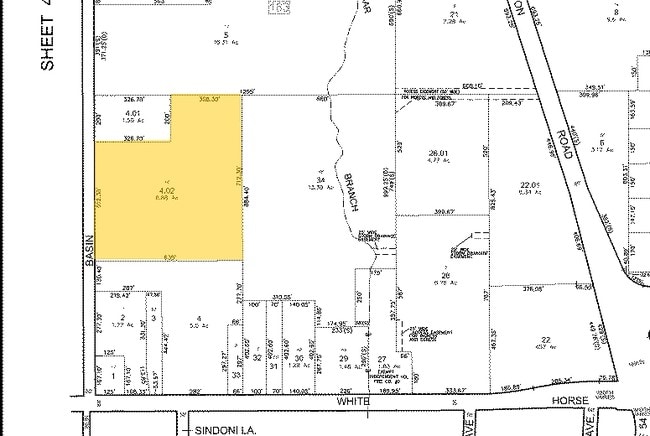
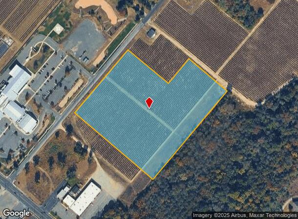
30 Basin Rd
13-04601-0000-00004-02
Atlantic
Vacantlandnec
New Jersey
X
4.2
34001C0018F
8.88 AC
2024
Atlantic City/Hammonton
2025
Philadelphia
010800
Atlantic City-Hammonton, NJ
DEMOGRAPHICS near 30 Basin Rd
1 Mile
3 Mile
5 Mile
2024 Total Population
2,636
12,878
17,353
2029 Population
2,553
12,521
16,915
Pop Growth 2024-2029
(3.15%)
(2.77%)
(2.52%)
Average Age
43
41
42
2024 Total Households
974
4,667
6,188
HH Growth 2024-2029
(4.00%)
(3.49%)
(3.18%)
Median Household Inc
$73,536
$76,036
$80,266
Avg Household Size
2.50
2.60
2.60
2024 Avg HH Vehicles
2.00
2.00
2.00
Median Home Value
$294,185
$272,045
$267,643
Median Year Built
1973
1971
1971
Nearby Places
Map Layers
Map Styles
 Street
 Aerial
- Restaurants
- Banks
- Shops
- Fitness
- Groceries
PUBLIC TRANSPORTATION
COMMUTER RAIL
Hammonton (Atlantic City Line - NJ Transit Commuter Rail (NJ Transit))
DRIVE
WALK
Distance
Hammonton (Atlantic City Line - NJ Transit Commuter Rail (NJ Transit))
4 min
2.2 mi
AIRPORT
Atlantic City International
DRIVE
WALK
Distance
Atlantic City International
48 min
21.7 mi
Philadelphia International
DRIVE
WALK
Distance
Philadelphia International
51 min
36.4 mi
Freight Ports
Broadway Terminal - Pier 5
DRIVE
WALK
Distance
Broadway Terminal - Pier 5
36 min
27.9 mi
SALE & LEASE HISTORY
LISTING DATE
SALE/LEASE

Sep 24, 2016
For Sale
Apr 05, 2020
For Sale
Nearby Properties
Address
Land Use
TOTAL SIZE
Lot Size
Zoning
Address
Land Use
TOTAL SIZE
Lot Size
Zoning
50.38 AC
Address
Land Use
TOTAL SIZE
Lot Size
Zoning
55.80 AC
Address
Land Use
TOTAL SIZE
Lot Size
Zoning
35.12 AC
Address
Land Use
TOTAL SIZE
Lot Size
Zoning
28.33 AC
R-3
Address
Land Use
TOTAL SIZE
Lot Size
Zoning
43.26 AC
R-1
Address
Land Use
TOTAL SIZE
Lot Size
Zoning
3,500 SF
4.77 AC
Address
Land Use
TOTAL SIZE
Lot Size
Zoning
Address
Land Use
TOTAL SIZE
Lot Size
Zoning
2,528 SF
21.85 AC
Address
Land Use
TOTAL SIZE
Lot Size
Zoning
Address
Land Use
TOTAL SIZE
Lot Size
Zoning
Address
Land Use
TOTAL SIZE
Lot Size
Zoning
14.85 AC
Address
Land Use
TOTAL SIZE
Lot Size
Zoning
Address
Land Use
TOTAL SIZE
Lot Size
Zoning
16.92 AC
Address
Land Use
TOTAL SIZE
Lot Size
Zoning
67,563 SF
13.73 AC
Address
Land Use
TOTAL SIZE
Lot Size
Zoning
0.92 AC
Address
Land Use
TOTAL SIZE
Lot Size
Zoning
27.35 AC
PA
Address
Land Use
TOTAL SIZE
Lot Size
Zoning
Address
Land Use
TOTAL SIZE
Lot Size
Zoning
43,282 SF
1.58 AC
Address
Land Use
TOTAL SIZE
Lot Size
Zoning
26,277 SF
1 AC
Address
Land Use
TOTAL SIZE
Lot Size
Zoning
2,190 SF
7.20 AC
Address
Land Use
TOTAL SIZE
Lot Size
Zoning
Address
Land Use
TOTAL SIZE
Lot Size
Zoning
10.91 AC
Address
Land Use
TOTAL SIZE
Lot Size
Zoning
10,520 SF
7.76 AC
Address
Land Use
TOTAL SIZE
Lot Size
Zoning
Address
Land Use
TOTAL SIZE
Lot Size
Zoning
7.14 AC
R-1
Address
Land Use
TOTAL SIZE
Lot Size
Zoning
Address
Land Use
TOTAL SIZE
Lot Size
Zoning
22.49 AC
Address
Land Use
TOTAL SIZE
Lot Size
Zoning
81.61 AC
Address
Land Use
TOTAL SIZE
Lot Size
Zoning
Address
Land Use
TOTAL SIZE
Lot Size
Zoning
12,580 SF
9.89 AC
R-1
The World's #1 Commercial Real Estate Marketplace
Connect with us
© 2025 CoStar Group
The information above has been obtained from sources believed reliable. While we do not doubt its accuracy we have not verified it and make no guarantee, warranty or representation about it. It is your responsibility to independently confirm its accuracy and completeness. Any projections, opinions, assumptions, or estimates used are for example only and do not represent the current or future performance of the property. The value of this transaction to you depends on tax and other factors which should be evaluated by your tax, financial, and legal advisors. You and your advisors should conduct a careful, independent investigation of the property to determine to your satisfaction the suitability of the property for your needs.