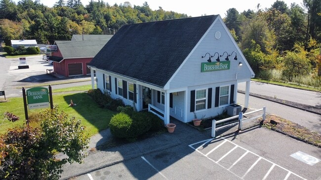
Property Record
30 E Otis Rd, Otis, MA 01253

Current Lease Availabilities
Property Detail
30 E Otis Rd
OTIS-000010D-000000-000041
Berkshire
Financialbuilding
Massachusetts
V-1
41
2025
0.39 AC
2025
Massachusetts North/West Area
933400
Other Market Areas
1,146 SF
Pittsfield, MA
NEARBY LISTINGS FOR SALE OR LEASE
-
-
View all Otis listings for lease on LoopNet.com
DEMOGRAPHICS near 30 E Otis Rd
1 mile
3 mile
5 mile
2025 Total Population
430
1,229
3,170
2030 Population
432
1,237
3,222
Pop Growth 2025-2030
+ 0.47%
+ 0.65%
+ 1.64%
Average Age
51
52
51
2025 Total Households
196
569
1,453
HH Growth 2025-2030
+ 0.51%
+ 0.70%
+ 1.72%
Median Household Inc
$105,645
$104,255
$97,452
Avg Household Size
2.20
2.10
2.20
2025 Avg HH Vehicles
2.00
2.00
2.00
Median Home Value
$368,055
$387,754
$408,717
Median Year Built
1978
1974
1975
Nearby Places
Map Layers
Map Styles
 Street
 Aerial
Transit
 Traffic
 Biking
Places
Listings with unknown addresses are not visible on the map
- Restaurants
- Banks
- Shops
- Fitness
- Groceries
PUBLIC TRANSPORTATION
AIRPORT
Bradley International
Drive
Walk
Distance
Bradley International
73 min
38.0 mi
Nearby Properties
Address
Land Use
TOTAL SIZE
Lot Size
Zoning
Address
Land Use
TOTAL SIZE
Lot Size
Zoning
48,738 SF
38.08 AC
R40
Address
Land Use
TOTAL SIZE
Lot Size
Zoning
3,049 SF
1.46 AC
R40
Address
Land Use
TOTAL SIZE
Lot Size
Zoning
15,432 SF
1.60 AC
V-1
Address
Land Use
TOTAL SIZE
Lot Size
Zoning
375 AC
RV
Address
Land Use
TOTAL SIZE
Lot Size
Zoning
528.70 AC
RV
Address
Land Use
TOTAL SIZE
Lot Size
Zoning
116.52 AC
R40
Address
Land Use
TOTAL SIZE
Lot Size
Zoning
19.99 AC
R40
Address
Land Use
TOTAL SIZE
Lot Size
Zoning
0.28 AC
R40
Address
Land Use
TOTAL SIZE
Lot Size
Zoning
1.25 AC
R40
Address
Land Use
TOTAL SIZE
Lot Size
Zoning
1,594 SF
129.65 AC
R40
Address
Land Use
TOTAL SIZE
Lot Size
Zoning
2,178 SF
40.32 AC
R40
Address
Land Use
TOTAL SIZE
Lot Size
Zoning
853.80 AC
R40
Address
Land Use
TOTAL SIZE
Lot Size
Zoning
0.29 AC
R40
Address
Land Use
TOTAL SIZE
Lot Size
Zoning
1 AC
R40
Address
Land Use
TOTAL SIZE
Lot Size
Zoning
1 AC
R40
Address
Land Use
TOTAL SIZE
Lot Size
Zoning
6.01 AC
R40
Address
Land Use
TOTAL SIZE
Lot Size
Zoning
15.07 AC
R-1A
Address
Land Use
TOTAL SIZE
Lot Size
Zoning
6.33 AC
R40
Address
Land Use
TOTAL SIZE
Lot Size
Zoning
3,906 SF
4.05 AC
R40
Address
Land Use
TOTAL SIZE
Lot Size
Zoning
2.64 AC
V-1
Address
Land Use
TOTAL SIZE
Lot Size
Zoning
800 SF
0.24 AC
R40
Address
Land Use
TOTAL SIZE
Lot Size
Zoning
32.56 AC
Address
Land Use
TOTAL SIZE
Lot Size
Zoning
0.85 AC
R40
Address
Land Use
TOTAL SIZE
Lot Size
Zoning
0.54 AC
R40
Address
Land Use
TOTAL SIZE
Lot Size
Zoning
3.28 AC
R40
Address
Land Use
TOTAL SIZE
Lot Size
Zoning
0.37 AC
R40
Address
Land Use
TOTAL SIZE
Lot Size
Zoning
153.70 AC
R40
Address
Land Use
TOTAL SIZE
Lot Size
Zoning
5.68 AC
V-1
Address
Land Use
TOTAL SIZE
Lot Size
Zoning
88.07 AC
R40
Address
Land Use
TOTAL SIZE
Lot Size
Zoning
0.25 AC
R40
The World's #1 Commercial Real Estate Marketplace
Connect with us
© 2026 CoStar Group
The information above has been obtained from sources believed reliable. While we do not doubt its accuracy we have not verified it and make no guarantee, warranty or representation about it. It is your responsibility to independently confirm its accuracy and completeness. Any projections, opinions, assumptions, or estimates used are for example only and do not represent the current or future performance of the property. The value of this transaction to you depends on tax and other factors which should be evaluated by your tax, financial, and legal advisors. You and your advisors should conduct a careful, independent investigation of the property to determine to your satisfaction the suitability of the property for your needs.