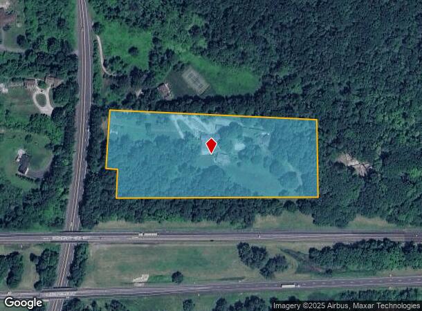
Property Record
30 East St, Stockbridge, MA 01262

NEARBY LISTINGS FOR SALE OR LEASE
Property Detail
30 East St
Pittsfield, MA
Berkshire
STOC-000218-000010
Massachusetts
Commercialnec
6.98 AC
2025
Massachusetts North/West Area
2025
Other Market Areas
924100
DEMOGRAPHICS near 30 East St
1 mile
3 mile
5 mile
2024 Total Population
384
6,459
12,996
2029 Population
381
6,422
12,955
Pop Growth 2024-2029
(0.78%)
(0.57%)
(0.32%)
Average Age
52
50
50
2024 Total Households
168
2,969
6,087
HH Growth 2024-2029
(1.19%)
(0.57%)
(0.33%)
Median Household Inc
$91,666
$68,126
$70,153
Avg Household Size
2.20
2.00
2.00
2024 Avg HH Vehicles
2.00
2.00
2.00
Median Home Value
$371,249
$343,724
$342,619
Median Year Built
1964
1957
1957
Nearby Places
Map Layers
Map Styles
 Street
 Aerial
Transit
 Traffic
 Biking
Places
Listings with unknown addresses are not visible on the map
- Restaurants
- Banks
- Shops
- Fitness
- Groceries
PUBLIC TRANSPORTATION
AIRPORT
Albany International
Drive
Walk
Distance
Albany International
64 min
48.7 mi
Freight Ports
Albany, NY Port
Drive
Walk
Distance
Albany, NY Port
50 min
40.5 mi
SALE & LEASE HISTORY
LISTING DATE
SALE/LEASE

Jan 04, 2022
For Sale
Nearby Properties
Address
Land Use
TOTAL SIZE
Lot Size
Zoning
Address
Land Use
TOTAL SIZE
Lot Size
Zoning
199,132 SF
35 AC
R20
Address
Land Use
TOTAL SIZE
Lot Size
Zoning
235,290 SF
106.98 AC
PCVC
Address
Land Use
TOTAL SIZE
Lot Size
Zoning
234,028 SF
13 AC
CR
Address
Land Use
TOTAL SIZE
Lot Size
Zoning
241 AC
R2
Address
Land Use
TOTAL SIZE
Lot Size
Zoning
61,851 SF
13.20 AC
RB
Address
Land Use
TOTAL SIZE
Lot Size
Zoning
162 AC
R2
Address
Land Use
TOTAL SIZE
Lot Size
Zoning
86 AC
R4
Address
Land Use
TOTAL SIZE
Lot Size
Zoning
334,077 SF
39 AC
I
Address
Land Use
TOTAL SIZE
Lot Size
Zoning
2 AC
B
Address
Land Use
TOTAL SIZE
Lot Size
Zoning
52,336 SF
9.63 AC
CBC
Address
Land Use
TOTAL SIZE
Lot Size
Zoning
62,662 SF
14.50 AC
CR
Address
Land Use
TOTAL SIZE
Lot Size
Zoning
36.02 AC
R2
Address
Land Use
TOTAL SIZE
Lot Size
Zoning
54,323 SF
3.50 AC
R20
Address
Land Use
TOTAL SIZE
Lot Size
Zoning
22.53 AC
R2
Address
Land Use
TOTAL SIZE
Lot Size
Zoning
48 AC
R-1A
Address
Land Use
TOTAL SIZE
Lot Size
Zoning
49,256 SF
7 AC
RA40
Address
Land Use
TOTAL SIZE
Lot Size
Zoning
7,602 SF
166.90 AC
RA40
Address
Land Use
TOTAL SIZE
Lot Size
Zoning
70,278 SF
5.23 AC
CR
Address
Land Use
TOTAL SIZE
Lot Size
Zoning
Address
Land Use
TOTAL SIZE
Lot Size
Zoning
885 SF
65 AC
RA40
Address
Land Use
TOTAL SIZE
Lot Size
Zoning
31,664 SF
1.93 AC
RC
Address
Land Use
TOTAL SIZE
Lot Size
Zoning
66,701 SF
15.96 AC
I
Address
Land Use
TOTAL SIZE
Lot Size
Zoning
8,088 SF
41.90 AC
R4
Address
Land Use
TOTAL SIZE
Lot Size
Zoning
7.60 AC
R-1A
Address
Land Use
TOTAL SIZE
Lot Size
Zoning
4,809 SF
3.32 AC
R2
Address
Land Use
TOTAL SIZE
Lot Size
Zoning
6,244 SF
8.50 AC
R2
Address
Land Use
TOTAL SIZE
Lot Size
Zoning
4.50 AC
RC
Address
Land Use
TOTAL SIZE
Lot Size
Zoning
3,808 SF
1.87 AC
DCBC
Address
Land Use
TOTAL SIZE
Lot Size
Zoning
96,152 SF
13.25 AC
OPLI
Address
Land Use
TOTAL SIZE
Lot Size
Zoning
11.40 AC
RC
The World's #1 Commercial Real Estate Marketplace
Connect with us
© 2026 CoStar Group
The information above has been obtained from sources believed reliable. While we do not doubt its accuracy we have not verified it and make no guarantee, warranty or representation about it. It is your responsibility to independently confirm its accuracy and completeness. Any projections, opinions, assumptions, or estimates used are for example only and do not represent the current or future performance of the property. The value of this transaction to you depends on tax and other factors which should be evaluated by your tax, financial, and legal advisors. You and your advisors should conduct a careful, independent investigation of the property to determine to your satisfaction the suitability of the property for your needs.