Property Record
30 Energy Dr Sw, Oronoco, MN 55960
NEARBY LISTINGS FOR SALE OR LEASE
-
-
View all Oronoco listings for sale on LoopNet.com
Property Detail
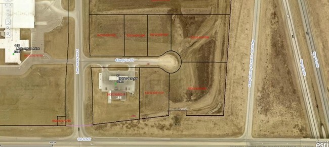
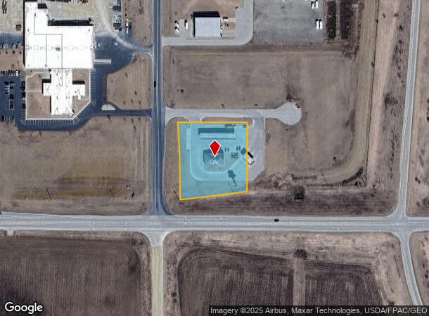
30 Energy Dr Sw
Rochester, MN
Oronoco Crossings 1St Repl
84.20.24.080211
SECT-20 TWP-108 RANGE-014 ORONOCO CROSSINGS 1ST REPL LOT-001 BLOCK-001 LOT 1 BLK 1
Servicestationmarket
Olmsted
X
Minnesota
27109C0043E
1
2025
1.84 AC
2024
Rochester
001902
Other Market Areas
3,268 SF
DEMOGRAPHICS near 30 Energy Dr Sw
1 Mile
3 Mile
5 Mile
2024 Total Population
846
3,262
21,471
2029 Population
846
3,299
21,911
Pop Growth 2024-2029
0.00%
+ 1.13%
+ 2.05%
Average Age
38
39
37
2024 Total Households
278
1,113
7,662
HH Growth 2024-2029
(0.36%)
+ 1.08%
+ 1.91%
Median Household Inc
$130,514
$119,052
$111,538
Avg Household Size
3.00
2.90
2.70
2024 Avg HH Vehicles
3.00
2.00
2.00
Median Home Value
$396,551
$401,366
$327,168
Median Year Built
1990
1987
2001
Nearby Places
Map Layers
Map Styles
 Street
 Aerial
- Restaurants
- Banks
- Shops
- Fitness
- Groceries
PUBLIC TRANSPORTATION
AIRPORT
Rochester International
DRIVE
WALK
Distance
Rochester International
23 min
18.0 mi
Freight Ports
Port Milwaukee
DRIVE
WALK
Distance
Port Milwaukee
317 min
287.5 mi
SALE & LEASE HISTORY
LISTING DATE
SALE/LEASE

Sep 24, 2016
For Sale
Jan 20, 2017
For Sale
Nearby Properties
Address
Land Use
TOTAL SIZE
Lot Size
Zoning
Address
Land Use
TOTAL SIZE
Lot Size
Zoning
77,297 SF
18.92 AC
Address
Land Use
TOTAL SIZE
Lot Size
Zoning
32,432 SF
16.45 AC
Address
Land Use
TOTAL SIZE
Lot Size
Zoning
48.22 AC
Address
Land Use
TOTAL SIZE
Lot Size
Zoning
17,280 SF
11.97 AC
Address
Land Use
TOTAL SIZE
Lot Size
Zoning
10,400 SF
9.99 AC
Address
Land Use
TOTAL SIZE
Lot Size
Zoning
2,872 SF
20 AC
Address
Land Use
TOTAL SIZE
Lot Size
Zoning
1,432 SF
11.40 AC
Address
Land Use
TOTAL SIZE
Lot Size
Zoning
15,000 SF
19.96 AC
Address
Land Use
TOTAL SIZE
Lot Size
Zoning
20,880 SF
3.25 AC
Address
Land Use
TOTAL SIZE
Lot Size
Zoning
40,632 SF
35.71 AC
Address
Land Use
TOTAL SIZE
Lot Size
Zoning
2,789 SF
160 AC
Address
Land Use
TOTAL SIZE
Lot Size
Zoning
12,000 SF
3.81 AC
Address
Land Use
TOTAL SIZE
Lot Size
Zoning
1,312 SF
16.40 AC
Address
Land Use
TOTAL SIZE
Lot Size
Zoning
15,680 SF
3.34 AC
Address
Land Use
TOTAL SIZE
Lot Size
Zoning
1,656 SF
160 AC
Address
Land Use
TOTAL SIZE
Lot Size
Zoning
96 SF
133.10 AC
Address
Land Use
TOTAL SIZE
Lot Size
Zoning
1,642 SF
155 AC
Address
Land Use
TOTAL SIZE
Lot Size
Zoning
38,668 SF
5.71 AC
Address
Land Use
TOTAL SIZE
Lot Size
Zoning
17,408 SF
0.58 AC
Address
Land Use
TOTAL SIZE
Lot Size
Zoning
8,912 SF
5 AC
Address
Land Use
TOTAL SIZE
Lot Size
Zoning
4,100 SF
2.06 AC
Address
Land Use
TOTAL SIZE
Lot Size
Zoning
1,052 SF
11 AC
Address
Land Use
TOTAL SIZE
Lot Size
Zoning
11,640 SF
8.60 AC
Address
Land Use
TOTAL SIZE
Lot Size
Zoning
12.44 AC
Address
Land Use
TOTAL SIZE
Lot Size
Zoning
13,254 SF
1 AC
Address
Land Use
TOTAL SIZE
Lot Size
Zoning
8,369 SF
8.01 AC
Address
Land Use
TOTAL SIZE
Lot Size
Zoning
Address
Land Use
TOTAL SIZE
Lot Size
Zoning
2,216 SF
12.30 AC
Address
Land Use
TOTAL SIZE
Lot Size
Zoning
2,384 SF
91.20 AC
The World's #1 Commercial Real Estate Marketplace
Connect with us
© 2026 CoStar Group
The information above has been obtained from sources believed reliable. While we do not doubt its accuracy we have not verified it and make no guarantee, warranty or representation about it. It is your responsibility to independently confirm its accuracy and completeness. Any projections, opinions, assumptions, or estimates used are for example only and do not represent the current or future performance of the property. The value of this transaction to you depends on tax and other factors which should be evaluated by your tax, financial, and legal advisors. You and your advisors should conduct a careful, independent investigation of the property to determine to your satisfaction the suitability of the property for your needs.