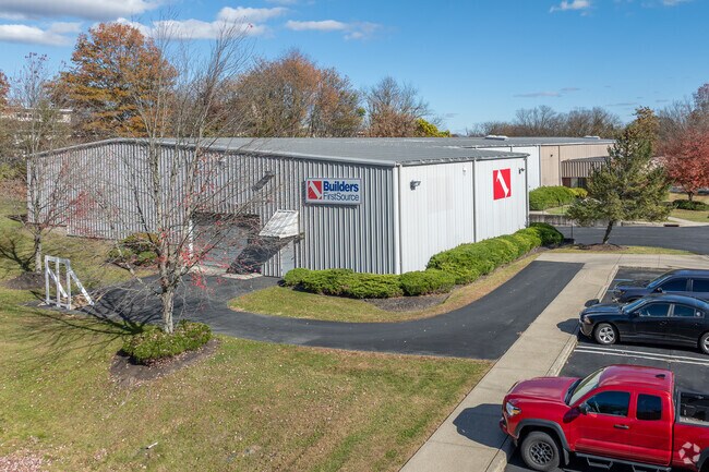
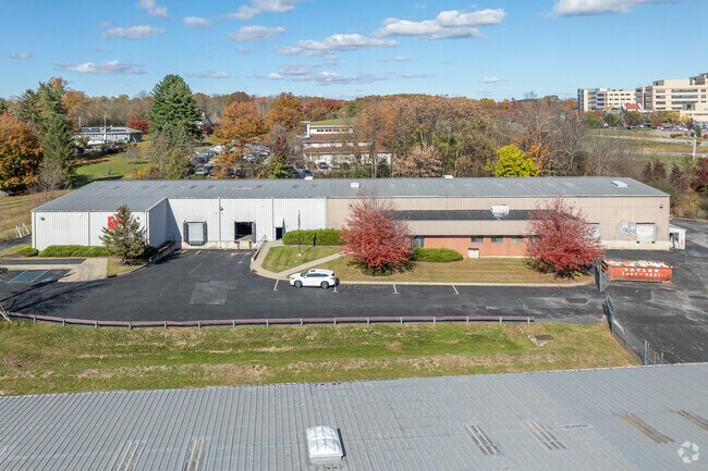
Property Record
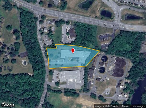
30 Golf Links Rd, Middletown, NY 10940
NEARBY LISTINGS FOR SALE OR LEASE
Property Detail
30 Golf Links Rd
New York-Jersey City-White Plains, NY-NJ
Garrison
335200-078-000-0001-067.200-0000
#4 GARRISON SUB MAP 6119
Warehouse
Orange
X
New York
36071C0278E
67.20
2024
3 AC
2024
Middletown
011200
Northern New Jersey
24,777 SF
DEMOGRAPHICS near 30 Golf Links Rd
1 Mile
3 Mile
5 Mile
2024 Total Population
1,860
44,046
71,393
2029 Population
1,946
44,699
72,640
Pop Growth 2024-2029
+ 4.62%
+ 1.48%
+ 1.75%
Average Age
43
39
40
2024 Total Households
745
15,917
26,139
HH Growth 2024-2029
+ 4.83%
+ 1.65%
+ 2.00%
Median Household Inc
$83,007
$76,213
$79,813
Avg Household Size
2.40
2.60
2.60
2024 Avg HH Vehicles
2.00
2.00
2.00
Median Home Value
$219,022
$257,976
$283,639
Median Year Built
1985
1973
1975
Nearby Places
- Restaurants
- Banks
- Shops
- Fitness
- Groceries
PUBLIC TRANSPORTATION
COMMUTER RAIL
Middletown New York (Bergen County/Port Jervis Line - NJ Transit Commuter Rail (NJ Transit), Main/Port Jervis Line - NJ Transit Commuter Rail (NJ Transit))
DRIVE
WALK
Distance
Middletown New York (Bergen County/Port Jervis Line - NJ Transit Commuter Rail (NJ Transit), Main/Port Jervis Line - NJ Transit Commuter Rail (NJ Transit))
8 min
2.7 mi
Campbell Hall (Bergen County/Port Jervis Line - NJ Transit Commuter Rail (NJ Transit), Main/Port Jervis Line - NJ Transit Commuter Rail (NJ Transit))
DRIVE
WALK
Distance
Campbell Hall (Bergen County/Port Jervis Line - NJ Transit Commuter Rail (NJ Transit), Main/Port Jervis Line - NJ Transit Commuter Rail (NJ Transit))
15 min
7.2 mi
AIRPORT
New York Stewart International
DRIVE
WALK
Distance
New York Stewart International
27 min
18.8 mi
Freight Ports
Port Newark Container Terminal
DRIVE
WALK
Distance
Port Newark Container Terminal
90 min
69.4 mi
Nearby Properties
Address
Land Use
TOTAL SIZE
Lot Size
Zoning
Address
Land Use
TOTAL SIZE
Lot Size
Zoning
101 AC
02069
Address
Land Use
TOTAL SIZE
Lot Size
Zoning
3,304 SF
80.10 AC
02069
Address
Land Use
TOTAL SIZE
Lot Size
Zoning
433,953 SF
90.64 AC
04200
Address
Land Use
TOTAL SIZE
Lot Size
Zoning
275,216 SF
58.40 AC
O/R
Address
Land Use
TOTAL SIZE
Lot Size
Zoning
40.40 AC
I-2
Address
Land Use
TOTAL SIZE
Lot Size
Zoning
47.80 AC
01092
Address
Land Use
TOTAL SIZE
Lot Size
Zoning
698,289 SF
52.20 AC
Address
Land Use
TOTAL SIZE
Lot Size
Zoning
134,566 SF
60 AC
02092
Address
Land Use
TOTAL SIZE
Lot Size
Zoning
180,840 SF
37.50 AC
TC
Address
Land Use
TOTAL SIZE
Lot Size
Zoning
24.40 AC
R-1
Address
Land Use
TOTAL SIZE
Lot Size
Zoning
58.10 AC
R1
Address
Land Use
TOTAL SIZE
Lot Size
Zoning
376,002 SF
34.40 AC
TC
Address
Land Use
TOTAL SIZE
Lot Size
Zoning
95,273 SF
31.60 AC
02069
Address
Land Use
TOTAL SIZE
Lot Size
Zoning
17.60 AC
R-1
Address
Land Use
TOTAL SIZE
Lot Size
Zoning
Address
Land Use
TOTAL SIZE
Lot Size
Zoning
14.70 AC
MC 1
Address
Land Use
TOTAL SIZE
Lot Size
Zoning
637,520 SF
44.70 AC
ENT-L
Address
Land Use
TOTAL SIZE
Lot Size
Zoning
142,416 SF
13.90 AC
R1
Address
Land Use
TOTAL SIZE
Lot Size
Zoning
1,044 SF
43.10 AC
Address
Land Use
TOTAL SIZE
Lot Size
Zoning
289,910 SF
19.90 AC
TC
Address
Land Use
TOTAL SIZE
Lot Size
Zoning
1,360 SF
6.30 AC
Address
Land Use
TOTAL SIZE
Lot Size
Zoning
270,471 SF
78.40 AC
R1
Address
Land Use
TOTAL SIZE
Lot Size
Zoning
136,784 SF
6 AC
O/R
Address
Land Use
TOTAL SIZE
Lot Size
Zoning
430,275 SF
35.60 AC
O/R
Address
Land Use
TOTAL SIZE
Lot Size
Zoning
5,753 SF
18 AC
TC
Address
Land Use
TOTAL SIZE
Lot Size
Zoning
125,616 SF
11.50 AC
O/R
Address
Land Use
TOTAL SIZE
Lot Size
Zoning
208,464 SF
24.90 AC
HC
Address
Land Use
TOTAL SIZE
Lot Size
Zoning
141,454 SF
12 AC
TC
Address
Land Use
TOTAL SIZE
Lot Size
Zoning
7 AC
C-3
Address
Land Use
TOTAL SIZE
Lot Size
Zoning
80,054 SF
3.90 AC
2034
The World's #1 Commercial Real Estate Marketplace
Connect with us
© 2025 CoStar Group
The information above has been obtained from sources believed reliable. While we do not doubt its accuracy we have not verified it and make no guarantee, warranty or representation about it. It is your responsibility to independently confirm its accuracy and completeness. Any projections, opinions, assumptions, or estimates used are for example only and do not represent the current or future performance of the property. The value of this transaction to you depends on tax and other factors which should be evaluated by your tax, financial, and legal advisors. You and your advisors should conduct a careful, independent investigation of the property to determine to your satisfaction the suitability of the property for your needs.