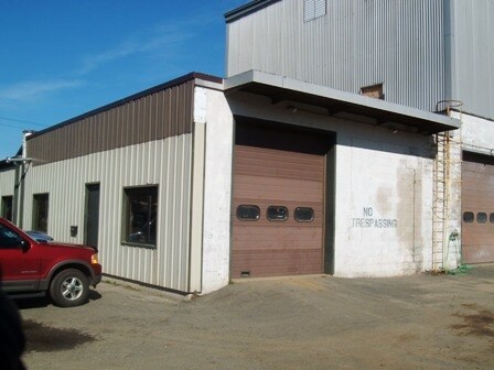
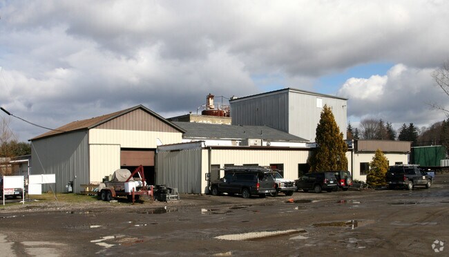
Property Record
30 Henry St, Bethel, CT 06801

Save to a Folder
{{folder.Name}}
{{folder.ListingIds.length}} Properties
{{folder.ListingIds.length}} Property
Create a New Folder
Property Detail
30 Henry St
BETH-000015-000022-000029
Western Ct
Industrialgeneral
Connecticut
I
29
AE The base floodplain where base flood elevations are provided. AE Zones are now used on new format FIRMs instead of A1-A30 Zones.
2.40 AC
2024
Bethel
2025
Westchester/So Connecticut
200100
Bridgeport-Stamford-Danbury, CT
10,573 SF
NEARBY LISTINGS FOR SALE OR LEASE
DEMOGRAPHICS near 30 Henry St
1 mile
3 mile
5 mile
2025 Total Population
8,043
51,232
101,982
2030 Population
8,227
51,992
103,531
Pop Growth 2025-2030
+ 2.29%
+ 1.48%
+ 1.52%
Average Age
42
40
41
2025 Total Households
3,248
19,231
37,356
HH Growth 2025-2030
+ 2.25%
+ 1.48%
+ 1.51%
Median Household Inc
$90,585
$82,385
$91,688
Avg Household Size
2.50
2.60
2.60
2025 Avg HH Vehicles
2.00
2.00
2.00
Median Home Value
$388,144
$403,570
$427,615
Median Year Built
1971
1970
1972
Nearby Places
Map Layers
Map Styles
 Street
 Aerial
Layers
 Traffic
 Biking
Places
Listings with unknown addresses are not visible on the map
- Restaurants
- Banks
- Shops
- Fitness
- Groceries
PUBLIC TRANSPORTATION
COMMUTER RAIL
Bethel (Danbury - Metro-North Railroad)
Drive
Walk
Distance
Bethel (Danbury - Metro-North Railroad)
4 min
18 min
0.9 mi
Danbury (Danbury - Metro-North Railroad)
Drive
Walk
Distance
Danbury (Danbury - Metro-North Railroad)
8 min
3.3 mi
AIRPORT
Westchester County
Drive
Walk
Distance
Westchester County
51 min
37.1 mi
Tweed/New Haven
Drive
Walk
Distance
Tweed/New Haven
62 min
37.7 mi
Freight Ports
Port of New Haven
Drive
Walk
Distance
Port of New Haven
57 min
34.9 mi
Nearby Properties
Address
Land Use
TOTAL SIZE
Lot Size
Zoning
Address
Land Use
TOTAL SIZE
Lot Size
Zoning
86,646 SF
122.26 AC
R-40
Address
Land Use
TOTAL SIZE
Lot Size
Zoning
7.98 AC
RH3
Address
Land Use
TOTAL SIZE
Lot Size
Zoning
33.50 AC
CG-20
Address
Land Use
TOTAL SIZE
Lot Size
Zoning
95,976 SF
4.14 AC
RH3
Address
Land Use
TOTAL SIZE
Lot Size
Zoning
478,816 SF
39.59 AC
IL40
Address
Land Use
TOTAL SIZE
Lot Size
Zoning
42.36 AC
R-3
Address
Land Use
TOTAL SIZE
Lot Size
Zoning
158,981 SF
12.79 AC
RA20
Address
Land Use
TOTAL SIZE
Lot Size
Zoning
45.78 AC
RM12
Address
Land Use
TOTAL SIZE
Lot Size
Zoning
7.28 AC
RH3
Address
Land Use
TOTAL SIZE
Lot Size
Zoning
17.24 AC
IL-40
Address
Land Use
TOTAL SIZE
Lot Size
Zoning
198,560 SF
3.30 AC
CLCB
Address
Land Use
TOTAL SIZE
Lot Size
Zoning
10.51 AC
IL40
Address
Land Use
TOTAL SIZE
Lot Size
Zoning
12.51 AC
IL40
Address
Land Use
TOTAL SIZE
Lot Size
Zoning
49.57 AC
CG-20
Address
Land Use
TOTAL SIZE
Lot Size
Zoning
58,000 SF
2.90 AC
RH3
Address
Land Use
TOTAL SIZE
Lot Size
Zoning
24.50 AC
RA8
Address
Land Use
TOTAL SIZE
Lot Size
Zoning
5.12 AC
CLCB
Address
Land Use
TOTAL SIZE
Lot Size
Zoning
304,561 SF
5.02 AC
IL40
Address
Land Use
TOTAL SIZE
Lot Size
Zoning
8,756 SF
8.10 AC
IL40
Address
Land Use
TOTAL SIZE
Lot Size
Zoning
55,229 SF
7 AC
R3
Address
Land Use
TOTAL SIZE
Lot Size
Zoning
92,843 SF
9.74 AC
CG20
Address
Land Use
TOTAL SIZE
Lot Size
Zoning
3.08 AC
CG-20
Address
Land Use
TOTAL SIZE
Lot Size
Zoning
107,256 SF
2.67 AC
CLCB
Address
Land Use
TOTAL SIZE
Lot Size
Zoning
56,658 SF
12 AC
RA40
Address
Land Use
TOTAL SIZE
Lot Size
Zoning
89,646 SF
1.35 AC
CLCB
Address
Land Use
TOTAL SIZE
Lot Size
Zoning
147.89 AC
IG-80
Address
Land Use
TOTAL SIZE
Lot Size
Zoning
19.10 AC
IL40
Address
Land Use
TOTAL SIZE
Lot Size
Zoning
64,285 SF
10.12 AC
RMF-4
Address
Land Use
TOTAL SIZE
Lot Size
Zoning
17.15 AC
IL40
Address
Land Use
TOTAL SIZE
Lot Size
Zoning
54,072 SF
2.06 AC
RH3
The World's #1 Commercial Real Estate Marketplace
Connect with us
© 2026 CoStar Group
The information above has been obtained from sources believed reliable. While we do not doubt its accuracy we have not verified it and make no guarantee, warranty or representation about it. It is your responsibility to independently confirm its accuracy and completeness. Any projections, opinions, assumptions, or estimates used are for example only and do not represent the current or future performance of the property. The value of this transaction to you depends on tax and other factors which should be evaluated by your tax, financial, and legal advisors. You and your advisors should conduct a careful, independent investigation of the property to determine to your satisfaction the suitability of the property for your needs.