Property Record
30 Jacks Bridge Rd, Londonderry, NH 03053

Save to a Folder
{{folder.Name}}
{{folder.ListingIds.length}} Properties
{{folder.ListingIds.length}} Property
Create a New Folder
Property Detail
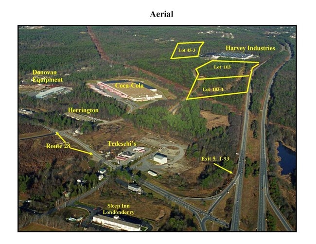
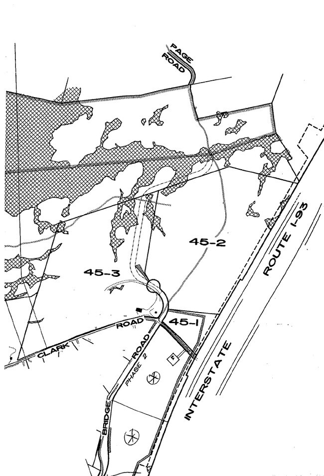
30 Jacks Bridge Rd
LOND-000017-000000-000045-000002
Rockingham
Warehouse
New Hampshire
IND-I
45-2
B and X Area of moderate flood hazard, usually the area between the limits of the 100-year and 500-year floods.
41.69 AC
2025
Rockingham
2025
Boston
003703
Boston-Cambridge-Newton, MA-NH
366,008 SF
NEARBY LISTINGS FOR SALE OR LEASE
DEMOGRAPHICS near 30 Jacks Bridge Rd
1 mile
3 mile
5 mile
2025 Total Population
2,008
17,306
79,648
2030 Population
2,071
17,801
80,481
Pop Growth 2025-2030
+ 3.14%
+ 2.86%
+ 1.05%
Average Age
40
41
41
2025 Total Households
756
6,589
31,973
HH Growth 2025-2030
+ 3.17%
+ 2.91%
+ 1.01%
Median Household Inc
$123,420
$119,779
$97,603
Avg Household Size
2.60
2.60
2.40
2025 Avg HH Vehicles
2.00
2.00
2.00
Median Home Value
$492,257
$473,274
$401,231
Median Year Built
1996
1990
1977
Nearby Places
Map Layers
Map Styles
 Street
 Aerial
Layers
 Traffic
 Biking
Places
Listings with unknown addresses are not visible on the map
- Restaurants
- Banks
- Shops
- Fitness
- Groceries
PUBLIC TRANSPORTATION
AIRPORT
Manchester Boston Regional
Drive
Walk
Distance
Manchester Boston Regional
20 min
7.3 mi
Freight Ports
Port of Boston
Drive
Walk
Distance
Port of Boston
78 min
49.3 mi
Nearby Properties
Address
Land Use
TOTAL SIZE
Lot Size
Zoning
Address
Land Use
TOTAL SIZE
Lot Size
Zoning
383,493 SF
34.51 AC
Address
Land Use
TOTAL SIZE
Lot Size
Zoning
8,064 SF
34.29 AC
Address
Land Use
TOTAL SIZE
Lot Size
Zoning
1,710 SF
65 AC
AR-I
Address
Land Use
TOTAL SIZE
Lot Size
Zoning
50.47 AC
GB
Address
Land Use
TOTAL SIZE
Lot Size
Zoning
723,875 SF
38.08 AC
Address
Land Use
TOTAL SIZE
Lot Size
Zoning
49,788 SF
34.73 AC
Address
Land Use
TOTAL SIZE
Lot Size
Zoning
180,600 SF
14.19 AC
IND-I
Address
Land Use
TOTAL SIZE
Lot Size
Zoning
487,970 SF
79.74 AC
IND-I
Address
Land Use
TOTAL SIZE
Lot Size
Zoning
201,831 SF
18.46 AC
IND-II
Address
Land Use
TOTAL SIZE
Lot Size
Zoning
119,139 SF
25.87 AC
IND-I
Address
Land Use
TOTAL SIZE
Lot Size
Zoning
142,318 SF
26.13 AC
GB
Address
Land Use
TOTAL SIZE
Lot Size
Zoning
227,589 SF
GB
Address
Land Use
TOTAL SIZE
Lot Size
Zoning
244,637 SF
27.28 AC
IND-II
Address
Land Use
TOTAL SIZE
Lot Size
Zoning
304,312 SF
29.62 AC
IND-II
Address
Land Use
TOTAL SIZE
Lot Size
Zoning
162,272 SF
9.69 AC
Address
Land Use
TOTAL SIZE
Lot Size
Zoning
24.20 AC
GB
Address
Land Use
TOTAL SIZE
Lot Size
Zoning
105,525 SF
11.76 AC
Address
Land Use
TOTAL SIZE
Lot Size
Zoning
125,060 SF
8.76 AC
IND-I
Address
Land Use
TOTAL SIZE
Lot Size
Zoning
75,032 SF
4.54 AC
Address
Land Use
TOTAL SIZE
Lot Size
Zoning
48,392 SF
8.32 AC
GB
Address
Land Use
TOTAL SIZE
Lot Size
Zoning
722 SF
65 AC
Address
Land Use
TOTAL SIZE
Lot Size
Zoning
105,926 SF
5.04 AC
Address
Land Use
TOTAL SIZE
Lot Size
Zoning
62,485 SF
6 AC
Address
Land Use
TOTAL SIZE
Lot Size
Zoning
100,800 SF
17.81 AC
4
Address
Land Use
TOTAL SIZE
Lot Size
Zoning
113,420 SF
7.31 AC
Address
Land Use
TOTAL SIZE
Lot Size
Zoning
71,810 SF
12.37 AC
Address
Land Use
TOTAL SIZE
Lot Size
Zoning
13.67 AC
R-III
Address
Land Use
TOTAL SIZE
Lot Size
Zoning
143,060 SF
10.04 AC
Address
Land Use
TOTAL SIZE
Lot Size
Zoning
60,246 SF
3 AC
The World's #1 Commercial Real Estate Marketplace
Connect with us
© 2026 CoStar Group
The information above has been obtained from sources believed reliable. While we do not doubt its accuracy we have not verified it and make no guarantee, warranty or representation about it. It is your responsibility to independently confirm its accuracy and completeness. Any projections, opinions, assumptions, or estimates used are for example only and do not represent the current or future performance of the property. The value of this transaction to you depends on tax and other factors which should be evaluated by your tax, financial, and legal advisors. You and your advisors should conduct a careful, independent investigation of the property to determine to your satisfaction the suitability of the property for your needs.