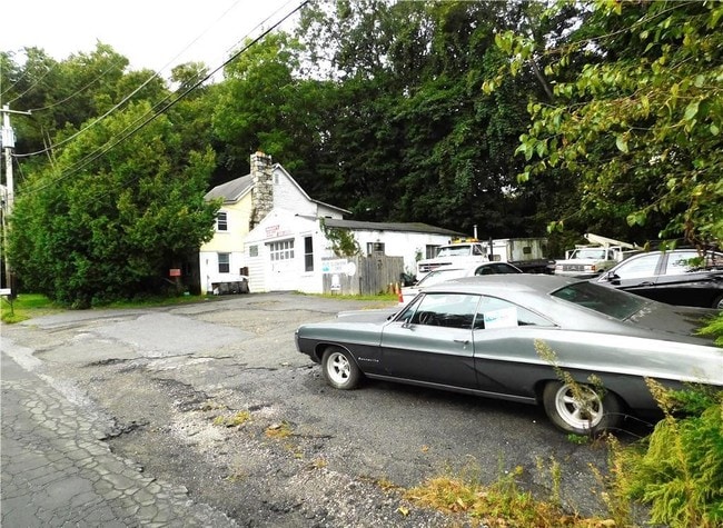
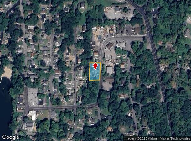
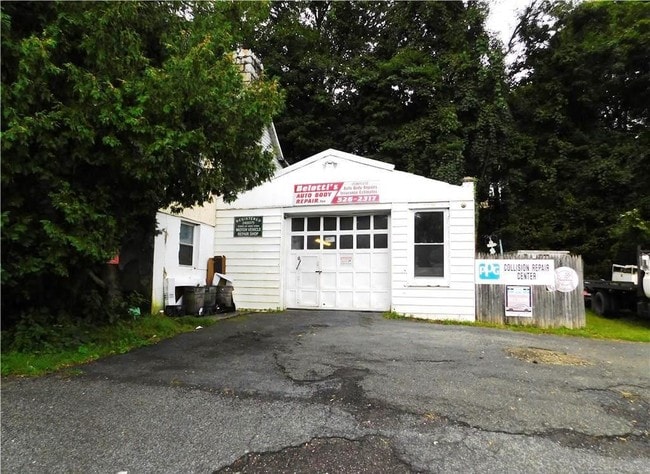
Property Record
30 Morrissey Dr, Putnam Valley, NY 10579
NEARBY LISTINGS FOR SALE OR LEASE
Property Detail
30 Morrissey Dr
372800-083-075-0001-031-000-0000
Putnam
Autorepair
New York
X
31.00
36079C0184E
0.37 AC
2024
Carmel
2024
Westchester/So Connecticut
010902
Dutchess County-Putnam County, NY
2,582 SF
DEMOGRAPHICS near 30 Morrissey Dr
1 Mile
3 Mile
5 Mile
2024 Total Population
5,138
30,062
79,025
2029 Population
5,111
29,521
77,480
Pop Growth 2024-2029
(0.53%)
(1.80%)
(1.96%)
Average Age
42
43
43
2024 Total Households
1,793
10,424
28,616
HH Growth 2024-2029
(0.50%)
(1.97%)
(2.13%)
Median Household Inc
$107,101
$121,368
$113,201
Avg Household Size
2.80
2.80
2.70
2024 Avg HH Vehicles
2.00
2.00
2.00
Median Home Value
$363,475
$404,509
$426,006
Median Year Built
1957
1962
1963
Nearby Places
- Restaurants
- Banks
- Shops
- Fitness
- Groceries
PUBLIC TRANSPORTATION
COMMUTER RAIL
Peekskill Station (Hudson Line - Metro-North Commuter Railroad Company (Metro-North))
DRIVE
WALK
Distance
Peekskill Station (Hudson Line - Metro-North Commuter Railroad Company (Metro-North))
13 min
6.4 mi
AIRPORT
New York Stewart International
DRIVE
WALK
Distance
New York Stewart International
52 min
28.2 mi
Westchester County
DRIVE
WALK
Distance
Westchester County
45 min
30.1 mi
Freight Ports
NY - Red Hook Container Terminal
DRIVE
WALK
Distance
NY - Red Hook Container Terminal
88 min
58.5 mi
SALE & LEASE HISTORY
LISTING DATE
SALE/LEASE

Jan 08, 2020
For Sale
Nearby Properties
Address
Land Use
TOTAL SIZE
Lot Size
Zoning
Address
Land Use
TOTAL SIZE
Lot Size
Zoning
363,657 SF
111.83 AC
B2
Address
Land Use
TOTAL SIZE
Lot Size
Zoning
78,331 SF
37.78 AC
R2
Address
Land Use
TOTAL SIZE
Lot Size
Zoning
78,529 SF
34.50 AC
R3
Address
Land Use
TOTAL SIZE
Lot Size
Zoning
95,159 SF
34.56 AC
B2
Address
Land Use
TOTAL SIZE
Lot Size
Zoning
5,380 SF
8.16 AC
CD
Address
Land Use
TOTAL SIZE
Lot Size
Zoning
18,865 SF
161.60 AC
PD
Address
Land Use
TOTAL SIZE
Lot Size
Zoning
13,520 SF
1.16 AC
CC1
Address
Land Use
TOTAL SIZE
Lot Size
Zoning
21,569 SF
61.43 AC
PD
Address
Land Use
TOTAL SIZE
Lot Size
Zoning
31,714 SF
13.88 AC
R2
Address
Land Use
TOTAL SIZE
Lot Size
Zoning
21,466 SF
2.87 AC
CC1
Address
Land Use
TOTAL SIZE
Lot Size
Zoning
13 AC
R1-40
Address
Land Use
TOTAL SIZE
Lot Size
Zoning
5,278 SF
67.05 AC
R3
Address
Land Use
TOTAL SIZE
Lot Size
Zoning
Address
Land Use
TOTAL SIZE
Lot Size
Zoning
6,056 SF
11 AC
CD
Address
Land Use
TOTAL SIZE
Lot Size
Zoning
1,632 SF
60.28 AC
PD
Address
Land Use
TOTAL SIZE
Lot Size
Zoning
14,058 SF
7.26 AC
PD
Address
Land Use
TOTAL SIZE
Lot Size
Zoning
15,070 SF
179.57 AC
B2
Address
Land Use
TOTAL SIZE
Lot Size
Zoning
2,092 SF
120.03 AC
R3
Address
Land Use
TOTAL SIZE
Lot Size
Zoning
Address
Land Use
TOTAL SIZE
Lot Size
Zoning
12,759 SF
17.16 AC
R2
Address
Land Use
TOTAL SIZE
Lot Size
Zoning
7,808 SF
2.03 AC
B2
Address
Land Use
TOTAL SIZE
Lot Size
Zoning
5,363 SF
4.82 AC
R2
Address
Land Use
TOTAL SIZE
Lot Size
Zoning
4,402 SF
5.38 AC
R2
Address
Land Use
TOTAL SIZE
Lot Size
Zoning
240.57 AC
CD
Address
Land Use
TOTAL SIZE
Lot Size
Zoning
7,848 SF
5.79 AC
R2
Address
Land Use
TOTAL SIZE
Lot Size
Zoning
9,707 SF
5.51 AC
R80
Address
Land Use
TOTAL SIZE
Lot Size
Zoning
6,186 SF
14.13 AC
R2
Address
Land Use
TOTAL SIZE
Lot Size
Zoning
3,111 SF
8.26 AC
R3
Address
Land Use
TOTAL SIZE
Lot Size
Zoning
8,834 SF
2.58 AC
CC1
Address
Land Use
TOTAL SIZE
Lot Size
Zoning
240 SF
25 AC
PD
The World's #1 Commercial Real Estate Marketplace
Connect with us
© 2025 CoStar Group
The information above has been obtained from sources believed reliable. While we do not doubt its accuracy we have not verified it and make no guarantee, warranty or representation about it. It is your responsibility to independently confirm its accuracy and completeness. Any projections, opinions, assumptions, or estimates used are for example only and do not represent the current or future performance of the property. The value of this transaction to you depends on tax and other factors which should be evaluated by your tax, financial, and legal advisors. You and your advisors should conduct a careful, independent investigation of the property to determine to your satisfaction the suitability of the property for your needs.