Property Record
30 North Dr Se, Acworth, GA 30102
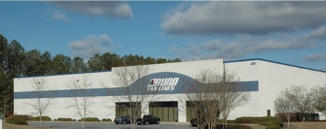

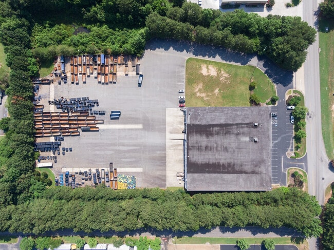

Property Detail
30 North Dr Se
0117-1241-003
TRACT H LL 1241 D 21
Distributionwarehouseregional
BARTOW
I1
Georgia
B and X Area of moderate flood hazard, usually the area between the limits of the 100-year and 500-year floods.
7.42 AC
2025
Kennesaw/Acworth
2025
Atlanta
960801
Atlanta-Sandy Springs-Roswell, GA
38,449 SF
NEARBY LISTINGS FOR SALE OR LEASE
DEMOGRAPHICS near 30 North Dr Se
1 mile
3 mile
5 mile
2025 Total Population
5,189
43,728
114,383
2030 Population
5,565
46,075
120,081
Pop Growth 2025-2030
+ 7.25%
+ 5.37%
+ 4.98%
Average Age
40
39
39
2025 Total Households
2,011
16,063
41,250
HH Growth 2025-2030
+ 7.01%
+ 5.32%
+ 4.95%
Median Household Inc
$71,953
$89,252
$94,310
Avg Household Size
2.50
2.70
2.70
2025 Avg HH Vehicles
2.00
2.00
2.00
Median Home Value
$318,792
$350,033
$360,768
Median Year Built
1997
1996
1995
Nearby Places
Map Layers
Map Styles
 Street
 Aerial
Layers
 Traffic
 Biking
Places
Listings with unknown addresses are not visible on the map
- Restaurants
- Banks
- Shops
- Fitness
- Groceries
SALE & LEASE HISTORY
LISTING DATE
SALE/LEASE

Jun 19, 2017
For Sale
Jul 13, 2022
For Sale
Jul 12, 2017
For Lease
Feb 16, 2017
For Sale
Nearby Properties
Address
Land Use
TOTAL SIZE
Lot Size
Zoning
Address
Land Use
TOTAL SIZE
Lot Size
Zoning
1,120 SF
42.20 AC
HI
Address
Land Use
TOTAL SIZE
Lot Size
Zoning
1,215,766 SF
39.92 AC
LI
Address
Land Use
TOTAL SIZE
Lot Size
Zoning
174,960 SF
3.99 AC
MU
Address
Land Use
TOTAL SIZE
Lot Size
Zoning
130,605 SF
21.38 AC
GC
Address
Land Use
TOTAL SIZE
Lot Size
Zoning
225,382 SF
18.67 AC
RM-8
Address
Land Use
TOTAL SIZE
Lot Size
Zoning
28,398 SF
22.95 AC
C1
Address
Land Use
TOTAL SIZE
Lot Size
Zoning
93,010 SF
8.99 AC
RM16
Address
Land Use
TOTAL SIZE
Lot Size
Zoning
350,984 SF
23.10 AC
LI
Address
Land Use
TOTAL SIZE
Lot Size
Zoning
200,596 SF
16.04 AC
RM-8
Address
Land Use
TOTAL SIZE
Lot Size
Zoning
311,900 SF
24.69 AC
LI
Address
Land Use
TOTAL SIZE
Lot Size
Zoning
195,600 SF
14.59 AC
LI
Address
Land Use
TOTAL SIZE
Lot Size
Zoning
652,178 SF
11.14 AC
LI
Address
Land Use
TOTAL SIZE
Lot Size
Zoning
128,292 SF
56.66 AC
I1
Address
Land Use
TOTAL SIZE
Lot Size
Zoning
138,482 SF
28.14 AC
R-40
Address
Land Use
TOTAL SIZE
Lot Size
Zoning
303,860 SF
LI
Address
Land Use
TOTAL SIZE
Lot Size
Zoning
107,514 SF
16.17 AC
LI
Address
Land Use
TOTAL SIZE
Lot Size
Zoning
156,945 SF
18.03 AC
RM-8
Address
Land Use
TOTAL SIZE
Lot Size
Zoning
216,432 SF
16.79 AC
LI
Address
Land Use
TOTAL SIZE
Lot Size
Zoning
61,867 SF
4 AC
Address
Land Use
TOTAL SIZE
Lot Size
Zoning
86,180 SF
54.76 AC
GC
Address
Land Use
TOTAL SIZE
Lot Size
Zoning
416,760 SF
12.74 AC
LI
Address
Land Use
TOTAL SIZE
Lot Size
Zoning
11.60 AC
IN
Address
Land Use
TOTAL SIZE
Lot Size
Zoning
214,920 SF
20.09 AC
I1
Address
Land Use
TOTAL SIZE
Lot Size
Zoning
212,290 SF
17.54 AC
Address
Land Use
TOTAL SIZE
Lot Size
Zoning
258,400 SF
19.55 AC
Address
Land Use
TOTAL SIZE
Lot Size
Zoning
192,215 SF
20.60 AC
C2
Address
Land Use
TOTAL SIZE
Lot Size
Zoning
69,249 SF
2.96 AC
MU
Address
Land Use
TOTAL SIZE
Lot Size
Zoning
1,186 SF
3.74 AC
Address
Land Use
TOTAL SIZE
Lot Size
Zoning
104,247 SF
16.45 AC
GC
Address
Land Use
TOTAL SIZE
Lot Size
Zoning
2,016 SF
12.29 AC
HI
The World's #1 Commercial Real Estate Marketplace
Connect with us
© 2026 CoStar Group
The information above has been obtained from sources believed reliable. While we do not doubt its accuracy we have not verified it and make no guarantee, warranty or representation about it. It is your responsibility to independently confirm its accuracy and completeness. Any projections, opinions, assumptions, or estimates used are for example only and do not represent the current or future performance of the property. The value of this transaction to you depends on tax and other factors which should be evaluated by your tax, financial, and legal advisors. You and your advisors should conduct a careful, independent investigation of the property to determine to your satisfaction the suitability of the property for your needs.