Property Record
30 Pine St, Stoneham, MA 02180
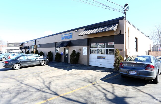

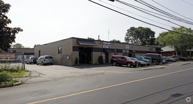
Property Detail
30 Pine St
STON-000013-000000-000040
Middlesex
Parkingstructure
Massachusetts
HB
40
B and X Area of moderate flood hazard, usually the area between the limits of the 100-year and 500-year floods.
0.77 AC
2025
Wilmington/Winchester
2025
Boston
337300
Boston-Cambridge-Newton, MA-NH
2,371 SF
NEARBY LISTINGS FOR SALE OR LEASE
DEMOGRAPHICS near 30 Pine St
1 mile
3 mile
5 mile
2025 Total Population
16,695
116,556
344,833
2030 Population
17,183
120,411
355,523
Pop Growth 2025-2030
+ 2.92%
+ 3.31%
+ 3.10%
Average Age
43
42
41
2025 Total Households
6,953
47,168
135,520
HH Growth 2025-2030
+ 3.06%
+ 3.45%
+ 3.26%
Median Household Inc
$117,551
$122,738
$117,784
Avg Household Size
2.30
2.40
2.50
2025 Avg HH Vehicles
2.00
2.00
2.00
Median Home Value
$713,294
$755,448
$761,351
Median Year Built
1957
1955
1956
Nearby Places
Map Layers
Map Styles
 Street
 Aerial
Transit
 Traffic
 Biking
Places
Listings with unknown addresses are not visible on the map
- Restaurants
- Banks
- Shops
- Fitness
- Groceries
PUBLIC TRANSPORTATION
COMMUTER RAIL
Melrose Highlands (Haverhill Line - Massachusetts Bay Transportation Authority Commuter Rail (Purple Line))
Drive
Walk
Distance
Melrose Highlands (Haverhill Line - Massachusetts Bay Transportation Authority Commuter Rail (Purple Line))
4 min
1.8 mi
Greenwood (Haverhill Line - Massachusetts Bay Transportation Authority Commuter Rail (Purple Line))
Drive
Walk
Distance
Greenwood (Haverhill Line - Massachusetts Bay Transportation Authority Commuter Rail (Purple Line))
4 min
1.9 mi
AIRPORT
General Edward Lawrence Logan International
Drive
Walk
Distance
General Edward Lawrence Logan International
21 min
12.1 mi
Freight Ports
Port of Boston
Drive
Walk
Distance
Port of Boston
21 min
11.8 mi
Nearby Properties
Address
Land Use
TOTAL SIZE
Lot Size
Zoning
Address
Land Use
TOTAL SIZE
Lot Size
Zoning
14.97 AC
C
Address
Land Use
TOTAL SIZE
Lot Size
Zoning
153,732 SF
12.50 AC
SCI
Address
Land Use
TOTAL SIZE
Lot Size
Zoning
476,332 SF
5.37 AC
Address
Land Use
TOTAL SIZE
Lot Size
Zoning
0.47 AC
M
Address
Land Use
TOTAL SIZE
Lot Size
Zoning
213,401 SF
15.16 AC
B
Address
Land Use
TOTAL SIZE
Lot Size
Zoning
720 SF
632 AC
SA8
Address
Land Use
TOTAL SIZE
Lot Size
Zoning
31.56 AC
HB
Address
Land Use
TOTAL SIZE
Lot Size
Zoning
191,050 SF
3.15 AC
Address
Land Use
TOTAL SIZE
Lot Size
Zoning
267,277 SF
60 AC
MD
Address
Land Use
TOTAL SIZE
Lot Size
Zoning
9.01 AC
S-I
Address
Land Use
TOTAL SIZE
Lot Size
Zoning
228,797 SF
10.61 AC
MD
Address
Land Use
TOTAL SIZE
Lot Size
Zoning
172,056 SF
I
Address
Land Use
TOTAL SIZE
Lot Size
Zoning
17.65 AC
B-I
Address
Land Use
TOTAL SIZE
Lot Size
Zoning
5.63 AC
C
Address
Land Use
TOTAL SIZE
Lot Size
Zoning
8.17 AC
RB
Address
Land Use
TOTAL SIZE
Lot Size
Zoning
6.28 AC
RB
Address
Land Use
TOTAL SIZE
Lot Size
Zoning
216,337 SF
7.19 AC
S20
Address
Land Use
TOTAL SIZE
Lot Size
Zoning
9 AC
C/R
Address
Land Use
TOTAL SIZE
Lot Size
Zoning
14,760 SF
1 AC
SR
Address
Land Use
TOTAL SIZE
Lot Size
Zoning
53,415 SF
11.02 AC
SCI
Address
Land Use
TOTAL SIZE
Lot Size
Zoning
62,853 SF
17.32 AC
R-2
Address
Land Use
TOTAL SIZE
Lot Size
Zoning
107,759 SF
22.42 AC
R-1
Address
Land Use
TOTAL SIZE
Lot Size
Zoning
11.06 AC
RB
Address
Land Use
TOTAL SIZE
Lot Size
Zoning
155,686 SF
2.88 AC
I
Address
Land Use
TOTAL SIZE
Lot Size
Zoning
48.16 AC
R-1
Address
Land Use
TOTAL SIZE
Lot Size
Zoning
50,810 SF
3.01 AC
RDB
Address
Land Use
TOTAL SIZE
Lot Size
Zoning
262,220 SF
11.79 AC
Address
Land Use
TOTAL SIZE
Lot Size
Zoning
5.09 AC
R-1
Address
Land Use
TOTAL SIZE
Lot Size
Zoning
167,470 SF
8.50 AC
B
Address
Land Use
TOTAL SIZE
Lot Size
Zoning
190,643 SF
38.88 AC
OS
The World's #1 Commercial Real Estate Marketplace
Connect with us
© 2026 CoStar Group
The information above has been obtained from sources believed reliable. While we do not doubt its accuracy we have not verified it and make no guarantee, warranty or representation about it. It is your responsibility to independently confirm its accuracy and completeness. Any projections, opinions, assumptions, or estimates used are for example only and do not represent the current or future performance of the property. The value of this transaction to you depends on tax and other factors which should be evaluated by your tax, financial, and legal advisors. You and your advisors should conduct a careful, independent investigation of the property to determine to your satisfaction the suitability of the property for your needs.