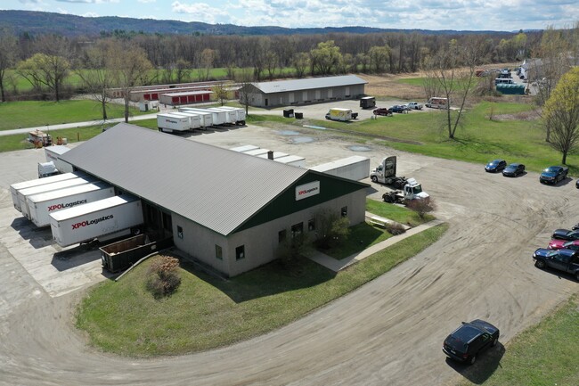
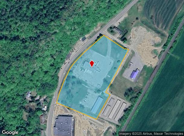
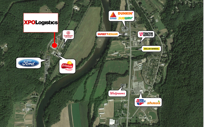
Property Record
30 Potter Industrial Dr, Westminster, VT 05158
NEARBY LISTINGS FOR SALE OR LEASE
Property Detail
30 Potter Industrial Dr
726-231-10062
BUILIDINGS AND LAND
Commercialnec
Windham
AE
Vermont
50025C0252E
6.60 AC
0
Vermont South Area
2024
Other Market Areas
967600
DEMOGRAPHICS near 30 Potter Industrial Dr
1 Mile
3 Mile
5 Mile
2024 Total Population
674
6,571
9,467
2029 Population
665
6,642
9,575
Pop Growth 2024-2029
(1.34%)
+ 1.08%
+ 1.14%
Average Age
46
44
45
2024 Total Households
306
2,964
4,220
HH Growth 2024-2029
(1.31%)
+ 0.84%
+ 0.88%
Median Household Inc
$69,893
$65,195
$67,261
Avg Household Size
2.20
2.20
2.20
2024 Avg HH Vehicles
2.00
2.00
2.00
Median Home Value
$250,925
$197,622
$220,883
Median Year Built
1967
1953
1961
Nearby Places
Map Layers
Map Styles
 Street
 Aerial
- Restaurants
- Banks
- Shops
- Fitness
- Groceries
PUBLIC TRANSPORTATION
COMMUTER RAIL
Bellows Falls Amtrak Station (Vermonter - Amtrak)
DRIVE
WALK
Distance
Bellows Falls Amtrak Station (Vermonter - Amtrak)
3 min
2.0 mi
Freight Ports
Albany, NY Port
DRIVE
WALK
Distance
Albany, NY Port
155 min
101.9 mi
SALE & LEASE HISTORY
LISTING DATE
SALE/LEASE

Apr 29, 2021
For Sale
Nearby Properties
Address
Land Use
TOTAL SIZE
Lot Size
Zoning
Address
Land Use
TOTAL SIZE
Lot Size
Zoning
13.51 AC
Address
Land Use
TOTAL SIZE
Lot Size
Zoning
Address
Land Use
TOTAL SIZE
Lot Size
Zoning
Address
Land Use
TOTAL SIZE
Lot Size
Zoning
Address
Land Use
TOTAL SIZE
Lot Size
Zoning
8.30 AC
Address
Land Use
TOTAL SIZE
Lot Size
Zoning
Address
Land Use
TOTAL SIZE
Lot Size
Zoning
Address
Land Use
TOTAL SIZE
Lot Size
Zoning
16.54 AC
RB R
Address
Land Use
TOTAL SIZE
Lot Size
Zoning
50.80 AC
Address
Land Use
TOTAL SIZE
Lot Size
Zoning
12.40 AC
Address
Land Use
TOTAL SIZE
Lot Size
Zoning
55,042 SF
12.15 AC
COM C
Address
Land Use
TOTAL SIZE
Lot Size
Zoning
Address
Land Use
TOTAL SIZE
Lot Size
Zoning
28,905 SF
5.85 AC
Address
Land Use
TOTAL SIZE
Lot Size
Zoning
1.90 AC
RB R
Address
Land Use
TOTAL SIZE
Lot Size
Zoning
60,615 SF
0.91 AC
Address
Land Use
TOTAL SIZE
Lot Size
Zoning
176 AC
IND I
Address
Land Use
TOTAL SIZE
Lot Size
Zoning
19,452 SF
4.92 AC
COM C
Address
Land Use
TOTAL SIZE
Lot Size
Zoning
31,161 SF
2.36 AC
NRB11N
Address
Land Use
TOTAL SIZE
Lot Size
Zoning
31,343 SF
3.34 AC
COM C
Address
Land Use
TOTAL SIZE
Lot Size
Zoning
62,674 SF
5.65 AC
NRB11N
Address
Land Use
TOTAL SIZE
Lot Size
Zoning
Address
Land Use
TOTAL SIZE
Lot Size
Zoning
4.04 AC
COM C
Address
Land Use
TOTAL SIZE
Lot Size
Zoning
9,891 SF
5.10 AC
RUR R
Address
Land Use
TOTAL SIZE
Lot Size
Zoning
8.80 AC
Address
Land Use
TOTAL SIZE
Lot Size
Zoning
15,187 SF
10 AC
NRB11N
Address
Land Use
TOTAL SIZE
Lot Size
Zoning
Address
Land Use
TOTAL SIZE
Lot Size
Zoning
20,063 SF
4.39 AC
RUR R
Address
Land Use
TOTAL SIZE
Lot Size
Zoning
25,902 SF
7.15 AC
IND I
Address
Land Use
TOTAL SIZE
Lot Size
Zoning
12,854 SF
0.27 AC
RB R
Address
Land Use
TOTAL SIZE
Lot Size
Zoning
23,079 SF
0.71 AC
COM C
The World's #1 Commercial Real Estate Marketplace
Connect with us
© 2026 CoStar Group
The information above has been obtained from sources believed reliable. While we do not doubt its accuracy we have not verified it and make no guarantee, warranty or representation about it. It is your responsibility to independently confirm its accuracy and completeness. Any projections, opinions, assumptions, or estimates used are for example only and do not represent the current or future performance of the property. The value of this transaction to you depends on tax and other factors which should be evaluated by your tax, financial, and legal advisors. You and your advisors should conduct a careful, independent investigation of the property to determine to your satisfaction the suitability of the property for your needs.