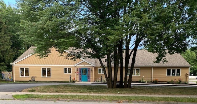
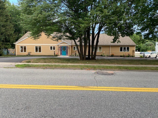
Property Record
30 Quarry Rd, Glastonbury, CT 06033

Save to a Folder
{{folder.Name}}
{{folder.ListingIds.length}} Properties
{{folder.ListingIds.length}} Property
Create a New Folder
Property Detail
30 Quarry Rd
GLAS-000009I-005720-S000001
Capitol
Commercialbuilding
Connecticut
RR
s0001
B and X Area of moderate flood hazard, usually the area between the limits of the 100-year and 500-year floods.
1.06 AC
2025
Glastonbury
2025
Hartford
520202
Hartford-West Hartford-East Hartford, CT
4,184 SF
NEARBY LISTINGS FOR SALE OR LEASE
-
-
View all Glastonbury listings for sale on LoopNet.com
DEMOGRAPHICS near 30 Quarry Rd
1 mile
3 mile
5 mile
2025 Total Population
1,880
19,141
50,100
2030 Population
1,911
19,466
51,037
Pop Growth 2025-2030
+ 1.65%
+ 1.70%
+ 1.87%
Average Age
42
42
43
2025 Total Households
678
7,230
19,654
HH Growth 2025-2030
+ 1.62%
+ 1.69%
+ 1.91%
Median Household Inc
$176,237
$164,421
$135,021
Avg Household Size
2.80
2.60
2.50
2025 Avg HH Vehicles
2.00
2.00
2.00
Median Home Value
$489,843
$471,986
$411,655
Median Year Built
1983
1974
1974
Nearby Places
Map Layers
Map Styles
 Street
 Aerial
Layers
 Traffic
 Biking
Places
Listings with unknown addresses are not visible on the map
- Restaurants
- Banks
- Shops
- Fitness
- Groceries
PUBLIC TRANSPORTATION
AIRPORT
Bradley International
Drive
Walk
Distance
Bradley International
40 min
25.2 mi
Tweed/New Haven
Drive
Walk
Distance
Tweed/New Haven
64 min
45.4 mi
Freight Ports
Port of New Haven
Drive
Walk
Distance
Port of New Haven
59 min
44.2 mi
SALE & LEASE HISTORY
LISTING DATE
SALE/LEASE

Aug 05, 2022
For Sale
Nearby Properties
Address
Land Use
TOTAL SIZE
Lot Size
Zoning
Address
Land Use
TOTAL SIZE
Lot Size
Zoning
49,219 SF
31.72 AC
Address
Land Use
TOTAL SIZE
Lot Size
Zoning
55.64 AC
Address
Land Use
TOTAL SIZE
Lot Size
Zoning
7.90 AC
Address
Land Use
TOTAL SIZE
Lot Size
Zoning
110,628 SF
28.81 AC
RR
Address
Land Use
TOTAL SIZE
Lot Size
Zoning
62,224 SF
RR
Address
Land Use
TOTAL SIZE
Lot Size
Zoning
57,480 SF
27.70 AC
RL
Address
Land Use
TOTAL SIZE
Lot Size
Zoning
57,153 SF
14.79 AC
RR
Address
Land Use
TOTAL SIZE
Lot Size
Zoning
Address
Land Use
TOTAL SIZE
Lot Size
Zoning
7.42 AC
PI
Address
Land Use
TOTAL SIZE
Lot Size
Zoning
55,074 SF
25.80 AC
RL
Address
Land Use
TOTAL SIZE
Lot Size
Zoning
6.73 AC
Address
Land Use
TOTAL SIZE
Lot Size
Zoning
42,622 SF
11.50 AC
Address
Land Use
TOTAL SIZE
Lot Size
Zoning
27,063 SF
5.94 AC
PI
Address
Land Use
TOTAL SIZE
Lot Size
Zoning
6,113 SF
11.03 AC
Address
Land Use
TOTAL SIZE
Lot Size
Zoning
16,324 SF
4 AC
Address
Land Use
TOTAL SIZE
Lot Size
Zoning
35,843 SF
13.07 AC
RR
Address
Land Use
TOTAL SIZE
Lot Size
Zoning
Address
Land Use
TOTAL SIZE
Lot Size
Zoning
13,178 SF
2.56 AC
PBD
Address
Land Use
TOTAL SIZE
Lot Size
Zoning
7.39 AC
Address
Land Use
TOTAL SIZE
Lot Size
Zoning
25,087 SF
6.01 AC
PI
Address
Land Use
TOTAL SIZE
Lot Size
Zoning
40,500 SF
3 AC
PI
Address
Land Use
TOTAL SIZE
Lot Size
Zoning
10,050 SF
1.39 AC
PI
Address
Land Use
TOTAL SIZE
Lot Size
Zoning
12,970 SF
1.84 AC
PI
Address
Land Use
TOTAL SIZE
Lot Size
Zoning
10.79 AC
Address
Land Use
TOTAL SIZE
Lot Size
Zoning
15,754 SF
2 AC
PBD
Address
Land Use
TOTAL SIZE
Lot Size
Zoning
1.81 AC
PI
Address
Land Use
TOTAL SIZE
Lot Size
Zoning
3,420 SF
12.70 AC
PI
Address
Land Use
TOTAL SIZE
Lot Size
Zoning
18,704 SF
1.28 AC
PI
Address
Land Use
TOTAL SIZE
Lot Size
Zoning
27,711 SF
3.33 AC
PI
Address
Land Use
TOTAL SIZE
Lot Size
Zoning
10,835 SF
0.98 AC
PI
The World's #1 Commercial Real Estate Marketplace
Connect with us
© 2026 CoStar Group
The information above has been obtained from sources believed reliable. While we do not doubt its accuracy we have not verified it and make no guarantee, warranty or representation about it. It is your responsibility to independently confirm its accuracy and completeness. Any projections, opinions, assumptions, or estimates used are for example only and do not represent the current or future performance of the property. The value of this transaction to you depends on tax and other factors which should be evaluated by your tax, financial, and legal advisors. You and your advisors should conduct a careful, independent investigation of the property to determine to your satisfaction the suitability of the property for your needs.