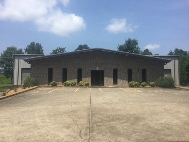
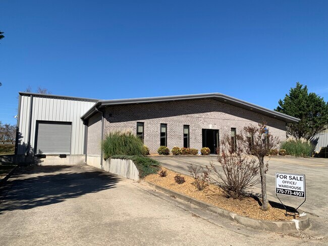
Property Record
30 River Ct Sw, Cartersville, GA 30120

Property Detail
30 River Ct Sw
C045-0001-008
LL 708 D 4 PB 65 PG 83 RIVERS EDGE
Industrialgeneral
Bartow
C and X Area of minimal flood hazard, usually depicted on FIRMs as above the 500-year flood level.
Georgia
2025
0.55 AC
2025
Kennesaw/Acworth
960901
Atlanta
6,498 SF
Atlanta-Sandy Springs-Roswell, GA
NEARBY LISTINGS FOR SALE OR LEASE
DEMOGRAPHICS near 30 River Ct Sw
1 mile
3 mile
5 mile
2025 Total Population
372
18,438
43,873
2030 Population
400
19,712
46,889
Pop Growth 2025-2030
+ 7.53%
+ 6.91%
+ 6.87%
Average Age
42
41
40
2025 Total Households
136
6,945
16,218
HH Growth 2025-2030
+ 7.35%
+ 6.88%
+ 6.88%
Median Household Inc
$89,772
$91,231
$84,292
Avg Household Size
2.70
2.60
2.60
2025 Avg HH Vehicles
2.00
2.00
2.00
Median Home Value
$342,000
$350,421
$320,221
Median Year Built
1993
1993
1991
Nearby Places
Map Layers
Map Styles
 Street
 Aerial
Layers
 Traffic
 Biking
Places
Listings with unknown addresses are not visible on the map
- Restaurants
- Banks
- Shops
- Fitness
- Groceries
SALE & LEASE HISTORY
LISTING DATE
SALE/LEASE

Aug 13, 2025
For Sale
Nearby Properties
Address
Land Use
TOTAL SIZE
Lot Size
Zoning
Address
Land Use
TOTAL SIZE
Lot Size
Zoning
226,108 SF
33.73 AC
Address
Land Use
TOTAL SIZE
Lot Size
Zoning
196,710 SF
149.63 AC
Address
Land Use
TOTAL SIZE
Lot Size
Zoning
104,757 SF
45 AC
IN
Address
Land Use
TOTAL SIZE
Lot Size
Zoning
149,158 SF
46.23 AC
IN
Address
Land Use
TOTAL SIZE
Lot Size
Zoning
Address
Land Use
TOTAL SIZE
Lot Size
Zoning
1,800 SF
102.03 AC
A1
Address
Land Use
TOTAL SIZE
Lot Size
Zoning
Address
Land Use
TOTAL SIZE
Lot Size
Zoning
88,974 SF
5.42 AC
IN
Address
Land Use
TOTAL SIZE
Lot Size
Zoning
24,991 SF
25.20 AC
Address
Land Use
TOTAL SIZE
Lot Size
Zoning
29,629 SF
21.90 AC
IN
Address
Land Use
TOTAL SIZE
Lot Size
Zoning
93,358 SF
22.63 AC
A1
Address
Land Use
TOTAL SIZE
Lot Size
Zoning
57,164 SF
4.88 AC
Address
Land Use
TOTAL SIZE
Lot Size
Zoning
470,504 SF
22.66 AC
IN
Address
Land Use
TOTAL SIZE
Lot Size
Zoning
34,786 SF
12.23 AC
IN
Address
Land Use
TOTAL SIZE
Lot Size
Zoning
Address
Land Use
TOTAL SIZE
Lot Size
Zoning
170,445 SF
6.12 AC
IN
Address
Land Use
TOTAL SIZE
Lot Size
Zoning
128.74 AC
A1
Address
Land Use
TOTAL SIZE
Lot Size
Zoning
61,132 SF
5.39 AC
Address
Land Use
TOTAL SIZE
Lot Size
Zoning
272.81 AC
A1
Address
Land Use
TOTAL SIZE
Lot Size
Zoning
6,909 SF
10 AC
IN
Address
Land Use
TOTAL SIZE
Lot Size
Zoning
Address
Land Use
TOTAL SIZE
Lot Size
Zoning
211,879 SF
23.57 AC
IN
Address
Land Use
TOTAL SIZE
Lot Size
Zoning
67,579 SF
18.97 AC
IN
Address
Land Use
TOTAL SIZE
Lot Size
Zoning
8,816 SF
5.20 AC
IN
Address
Land Use
TOTAL SIZE
Lot Size
Zoning
2,632 SF
52.90 AC
IN
Address
Land Use
TOTAL SIZE
Lot Size
Zoning
40,000 SF
18.15 AC
Address
Land Use
TOTAL SIZE
Lot Size
Zoning
313,640 SF
24.12 AC
IN
Address
Land Use
TOTAL SIZE
Lot Size
Zoning
242,214 SF
14.71 AC
IN
Address
Land Use
TOTAL SIZE
Lot Size
Zoning
4,466 SF
4.95 AC
IN
Address
Land Use
TOTAL SIZE
Lot Size
Zoning
25,271 SF
11.28 AC
IN
The World's #1 Commercial Real Estate Marketplace
Connect with us
© 2026 CoStar Group
The information above has been obtained from sources believed reliable. While we do not doubt its accuracy we have not verified it and make no guarantee, warranty or representation about it. It is your responsibility to independently confirm its accuracy and completeness. Any projections, opinions, assumptions, or estimates used are for example only and do not represent the current or future performance of the property. The value of this transaction to you depends on tax and other factors which should be evaluated by your tax, financial, and legal advisors. You and your advisors should conduct a careful, independent investigation of the property to determine to your satisfaction the suitability of the property for your needs.