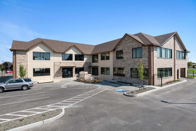
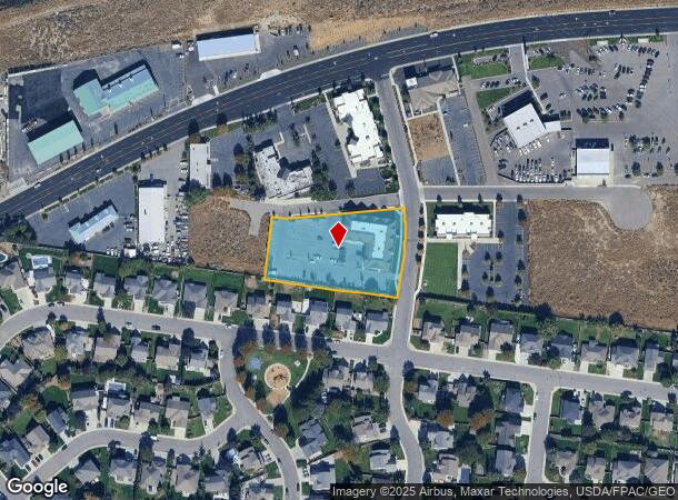
Property Record
30 S Louisiana St, Kennewick, WA 99336
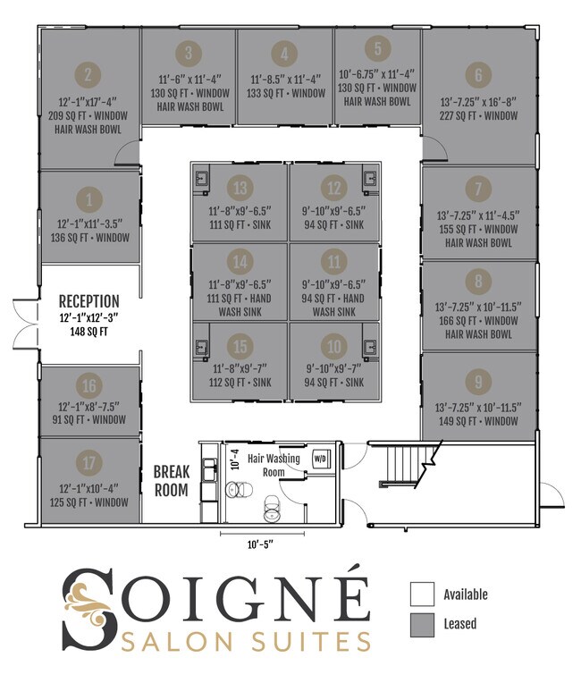
Current Lease Availabilities
NEARBY LISTINGS FOR SALE OR LEASE
Property Detail
30 S Louisiana St
Other Market Areas
Short Plat #2960
Kennewick-Richland, WA
SECTION 6 TOWNSHIP 8 RANGE 29 QUARTER NW; SHORT PLAT #2960, LOT 5, RECORDED 9/20/2006, UNDER AUDITORS FILE NO. 2006-031017. RECORDED IN VOLUME 1 OF SHORT PLATS PAGE 2960, RECORDS OF BENTON COUNTY, WASHINGTON.
106892012960005
Benton
Commercialnec
Washington
2024
5
2024
1.38 AC
010816
Yakima/Kennewick
21,840 SF
DEMOGRAPHICS near 30 S Louisiana St
1 Mile
3 Mile
5 Mile
2024 Total Population
10,611
58,688
132,953
2029 Population
11,372
63,266
143,399
Pop Growth 2024-2029
+ 7.17%
+ 7.80%
+ 7.86%
Average Age
40
39
38
2024 Total Households
4,262
22,678
48,995
HH Growth 2024-2029
+ 7.18%
+ 7.85%
+ 7.87%
Median Household Inc
$84,181
$78,712
$80,725
Avg Household Size
2.50
2.50
2.70
2024 Avg HH Vehicles
2.00
2.00
2.00
Median Home Value
$356,122
$364,418
$363,990
Median Year Built
2000
1996
1994
Nearby Places
Map Layers
Map Styles
 Street
 Aerial
- Restaurants
- Banks
- Shops
- Fitness
- Groceries
PUBLIC TRANSPORTATION
COMMUTER RAIL
Pasco Amtrak Station (Empire Builder - Amtrak)
DRIVE
WALK
Distance
Pasco Amtrak Station (Empire Builder - Amtrak)
17 min
8.8 mi
AIRPORT
Tri-Cities
DRIVE
WALK
Distance
Tri-Cities
16 min
8.8 mi
Freight Ports
Port of Tacoma
DRIVE
WALK
Distance
Port of Tacoma
266 min
232.7 mi
Nearby Properties
Address
Land Use
TOTAL SIZE
Lot Size
Zoning
Address
Land Use
TOTAL SIZE
Lot Size
Zoning
614,021 SF
45.64 AC
Address
Land Use
TOTAL SIZE
Lot Size
Zoning
478,378 SF
25.15 AC
KENNEWICK
Address
Land Use
TOTAL SIZE
Lot Size
Zoning
192,199 SF
Address
Land Use
TOTAL SIZE
Lot Size
Zoning
378,471 SF
16.21 AC
RICHLAND -
Address
Land Use
TOTAL SIZE
Lot Size
Zoning
190,434 SF
47.42 AC
Address
Land Use
TOTAL SIZE
Lot Size
Zoning
232,463 SF
31.54 AC
Address
Land Use
TOTAL SIZE
Lot Size
Zoning
141,940 SF
7.49 AC
Address
Land Use
TOTAL SIZE
Lot Size
Zoning
138,421 SF
31.09 AC
Address
Land Use
TOTAL SIZE
Lot Size
Zoning
238,088 SF
17.06 AC
Address
Land Use
TOTAL SIZE
Lot Size
Zoning
195,749 SF
12.29 AC
35
Address
Land Use
TOTAL SIZE
Lot Size
Zoning
224,114 SF
13.37 AC
Address
Land Use
TOTAL SIZE
Lot Size
Zoning
248,623 SF
12 AC
Address
Land Use
TOTAL SIZE
Lot Size
Zoning
168,650 SF
10.43 AC
KENNEWICK
Address
Land Use
TOTAL SIZE
Lot Size
Zoning
Address
Land Use
TOTAL SIZE
Lot Size
Zoning
159,807 SF
Address
Land Use
TOTAL SIZE
Lot Size
Zoning
179,139 SF
11.79 AC
Address
Land Use
TOTAL SIZE
Lot Size
Zoning
206,208 SF
10.01 AC
KENNEWICK
Address
Land Use
TOTAL SIZE
Lot Size
Zoning
80,622 SF
27.34 AC
Address
Land Use
TOTAL SIZE
Lot Size
Zoning
82,470 SF
12.38 AC
Address
Land Use
TOTAL SIZE
Lot Size
Zoning
200,734 SF
12.38 AC
Address
Land Use
TOTAL SIZE
Lot Size
Zoning
126,589 SF
4.05 AC
Address
Land Use
TOTAL SIZE
Lot Size
Zoning
74,556 SF
1.22 AC
Address
Land Use
TOTAL SIZE
Lot Size
Zoning
144,723 SF
6.88 AC
Address
Land Use
TOTAL SIZE
Lot Size
Zoning
118,412 SF
9.91 AC
KENNEWICK
Address
Land Use
TOTAL SIZE
Lot Size
Zoning
52,900 SF
10.23 AC
Address
Land Use
TOTAL SIZE
Lot Size
Zoning
78,836 SF
13.64 AC
Address
Land Use
TOTAL SIZE
Lot Size
Zoning
127,840 SF
3.69 AC
Address
Land Use
TOTAL SIZE
Lot Size
Zoning
157,320 SF
3.80 AC
53
Address
Land Use
TOTAL SIZE
Lot Size
Zoning
116,283 SF
11.18 AC
RICHLAND -
Address
Land Use
TOTAL SIZE
Lot Size
Zoning
105,026 SF
8.63 AC
KENNEWICK
The World's #1 Commercial Real Estate Marketplace
Connect with us
© 2025 CoStar Group
The information above has been obtained from sources believed reliable. While we do not doubt its accuracy we have not verified it and make no guarantee, warranty or representation about it. It is your responsibility to independently confirm its accuracy and completeness. Any projections, opinions, assumptions, or estimates used are for example only and do not represent the current or future performance of the property. The value of this transaction to you depends on tax and other factors which should be evaluated by your tax, financial, and legal advisors. You and your advisors should conduct a careful, independent investigation of the property to determine to your satisfaction the suitability of the property for your needs.