Property Record
30 Sandy Point Farm Rd, Portsmouth, RI 02871
NEARBY LISTINGS FOR SALE OR LEASE
-
-
View all Portsmouth listings for sale on LoopNet.com
Property Detail
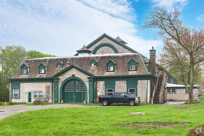
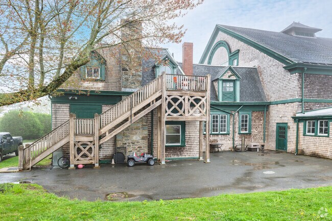
30 Sandy Point Farm Rd
Commercialofficeresidentialmixeduse
Newport
X
Rhode Island
44005C0111J
1.63 AC
2025
Newport County
2025
Providence
040102
Providence-Warwick, RI-MA
30,269 SF
PORT-000062-000000-000017A
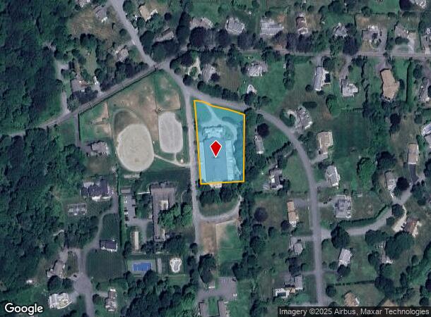
DEMOGRAPHICS near 30 Sandy Point Farm Rd
1 Mile
3 Mile
5 Mile
2024 Total Population
999
13,773
39,238
2029 Population
985
13,460
38,280
Pop Growth 2024-2029
(1.40%)
(2.27%)
(2.44%)
Average Age
46
46
45
2024 Total Households
388
5,485
16,281
HH Growth 2024-2029
(1.55%)
(2.44%)
(2.70%)
Median Household Inc
$118,541
$111,679
$94,655
Avg Household Size
2.50
2.50
2.30
2024 Avg HH Vehicles
2.00
2.00
2.00
Median Home Value
$677,365
$577,612
$521,715
Median Year Built
1977
1975
1969
Nearby Places
Map Layers
Map Styles
 Street
 Aerial
- Restaurants
- Banks
- Shops
- Fitness
- Groceries
PUBLIC TRANSPORTATION
AIRPORT
Rhode Island Tf Green International
DRIVE
WALK
Distance
Rhode Island Tf Green International
55 min
33.5 mi
Freight Ports
Port of Davisville, RI
DRIVE
WALK
Distance
Port of Davisville, RI
41 min
22.3 mi
Nearby Properties
Address
Land Use
TOTAL SIZE
Lot Size
Zoning
Address
Land Use
TOTAL SIZE
Lot Size
Zoning
24.70 AC
RMA
Address
Land Use
TOTAL SIZE
Lot Size
Zoning
120.20 AC
HI
Address
Land Use
TOTAL SIZE
Lot Size
Zoning
157,806 SF
36.80 AC
R30
Address
Land Use
TOTAL SIZE
Lot Size
Zoning
33 AC
PA
Address
Land Use
TOTAL SIZE
Lot Size
Zoning
26.66 AC
R20
Address
Land Use
TOTAL SIZE
Lot Size
Zoning
99,369 SF
15.88 AC
GBA
Address
Land Use
TOTAL SIZE
Lot Size
Zoning
9.01 AC
R20
Address
Land Use
TOTAL SIZE
Lot Size
Zoning
38 AC
OS
Address
Land Use
TOTAL SIZE
Lot Size
Zoning
75,818 SF
7.51 AC
GBA
Address
Land Use
TOTAL SIZE
Lot Size
Zoning
4.38 AC
GB
Address
Land Use
TOTAL SIZE
Lot Size
Zoning
56.41 AC
R40
Address
Land Use
TOTAL SIZE
Lot Size
Zoning
44,815 SF
5 AC
R20
Address
Land Use
TOTAL SIZE
Lot Size
Zoning
40,664 SF
4.51 AC
P
Address
Land Use
TOTAL SIZE
Lot Size
Zoning
44.80 AC
R20
Address
Land Use
TOTAL SIZE
Lot Size
Zoning
33,128 SF
3.40 AC
GBA
Address
Land Use
TOTAL SIZE
Lot Size
Zoning
39,116 SF
1 AC
R30
Address
Land Use
TOTAL SIZE
Lot Size
Zoning
222.84 AC
L1
Address
Land Use
TOTAL SIZE
Lot Size
Zoning
44 AC
R60
Address
Land Use
TOTAL SIZE
Lot Size
Zoning
3,860 SF
2.40 AC
R60
Address
Land Use
TOTAL SIZE
Lot Size
Zoning
4,520 SF
2 AC
R60
Address
Land Use
TOTAL SIZE
Lot Size
Zoning
8.10 AC
P
Address
Land Use
TOTAL SIZE
Lot Size
Zoning
60,480 SF
3.88 AC
R20
Address
Land Use
TOTAL SIZE
Lot Size
Zoning
3.47 AC
R60
Address
Land Use
TOTAL SIZE
Lot Size
Zoning
4 AC
R30
Address
Land Use
TOTAL SIZE
Lot Size
Zoning
29,600 SF
15.55 AC
L1A
Address
Land Use
TOTAL SIZE
Lot Size
Zoning
17,246 SF
171.27 AC
OS
Address
Land Use
TOTAL SIZE
Lot Size
Zoning
10.46 AC
R20
Address
Land Use
TOTAL SIZE
Lot Size
Zoning
31,680 SF
2.67 AC
GBA
Address
Land Use
TOTAL SIZE
Lot Size
Zoning
4,270 SF
6.50 AC
R40
Address
Land Use
TOTAL SIZE
Lot Size
Zoning
5.12 AC
GBA
The World's #1 Commercial Real Estate Marketplace
Connect with us
© 2025 CoStar Group
The information above has been obtained from sources believed reliable. While we do not doubt its accuracy we have not verified it and make no guarantee, warranty or representation about it. It is your responsibility to independently confirm its accuracy and completeness. Any projections, opinions, assumptions, or estimates used are for example only and do not represent the current or future performance of the property. The value of this transaction to you depends on tax and other factors which should be evaluated by your tax, financial, and legal advisors. You and your advisors should conduct a careful, independent investigation of the property to determine to your satisfaction the suitability of the property for your needs.