Property Record
30 Spears Creek Ch Rd, Elgin, SC 29045
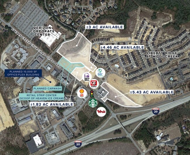

This Property Is For Sale
Property Detail
30 Spears Creek Ch Rd
28800-01-09
#SU #PR RB2478-3402/3403 2474-1923
Agriculturalland
RICHLAND
PD
South Carolina
AE The base floodplain where base flood elevations are provided. AE Zones are now used on new format FIRMs instead of A1-A30 Zones.
80.36 AC
2025
Northeast Columbia
2024
Columbia
970909
Columbia, SC
NEARBY LISTINGS FOR SALE OR LEASE
-
-
-
-
-
-
No Photo
-
View all Elgin listings for sale on LoopNet.com
DEMOGRAPHICS near 30 Spears Creek Ch Rd
1 mile
3 mile
5 mile
2025 Total Population
3,086
21,318
62,282
2030 Population
3,289
22,322
64,734
Pop Growth 2025-2030
+ 6.58%
+ 4.71%
+ 3.94%
Average Age
38
39
39
2025 Total Households
1,213
8,388
24,263
HH Growth 2025-2030
+ 6.68%
+ 4.84%
+ 4.07%
Median Household Inc
$92,124
$89,065
$81,399
Avg Household Size
2.50
2.50
2.50
2025 Avg HH Vehicles
2.00
2.00
2.00
Median Home Value
$301,351
$284,905
$260,261
Median Year Built
2010
2004
2000
Nearby Places
Map Layers
Map Styles
 Street
 Aerial
Layers
 Traffic
 Biking
Places
Listings with unknown addresses are not visible on the map
- Restaurants
- Banks
- Shops
- Fitness
- Groceries
Nearby Properties
Address
Land Use
TOTAL SIZE
Lot Size
Zoning
Address
Land Use
TOTAL SIZE
Lot Size
Zoning
298,100 SF
74.42 AC
C-3
Address
Land Use
TOTAL SIZE
Lot Size
Zoning
329,677 SF
17.12 AC
PDD
Address
Land Use
TOTAL SIZE
Lot Size
Zoning
313,664 SF
33.91 AC
RG-2
Address
Land Use
TOTAL SIZE
Lot Size
Zoning
298,080 SF
18.10 AC
RU
Address
Land Use
TOTAL SIZE
Lot Size
Zoning
299,353 SF
12.36 AC
GC
Address
Land Use
TOTAL SIZE
Lot Size
Zoning
210,926 SF
22 AC
HI
Address
Land Use
TOTAL SIZE
Lot Size
Zoning
360,163 SF
20.11 AC
RM-MD
Address
Land Use
TOTAL SIZE
Lot Size
Zoning
245,825 SF
11 AC
RS-2
Address
Land Use
TOTAL SIZE
Lot Size
Zoning
275,286 SF
15.53 AC
PD
Address
Land Use
TOTAL SIZE
Lot Size
Zoning
31,625 SF
3.30 AC
GC
Address
Land Use
TOTAL SIZE
Lot Size
Zoning
84,860 SF
5.13 AC
PUD-R
Address
Land Use
TOTAL SIZE
Lot Size
Zoning
81,951 SF
11.81 AC
M-1
Address
Land Use
TOTAL SIZE
Lot Size
Zoning
194,728 SF
12.28 AC
RM-MD
Address
Land Use
TOTAL SIZE
Lot Size
Zoning
118,547 SF
10.64 AC
GC
Address
Land Use
TOTAL SIZE
Lot Size
Zoning
126,352 SF
10.43 AC
M-1
Address
Land Use
TOTAL SIZE
Lot Size
Zoning
53,984 SF
15 AC
C-3
Address
Land Use
TOTAL SIZE
Lot Size
Zoning
8,800 SF
2.12 AC
GC
Address
Land Use
TOTAL SIZE
Lot Size
Zoning
148,156 SF
29.79 AC
PUD-C
Address
Land Use
TOTAL SIZE
Lot Size
Zoning
49,705 SF
6.50 AC
C-3
Address
Land Use
TOTAL SIZE
Lot Size
Zoning
186,393 SF
13.12 AC
HI
Address
Land Use
TOTAL SIZE
Lot Size
Zoning
55,035 SF
5.47 AC
GC
Address
Land Use
TOTAL SIZE
Lot Size
Zoning
11,550 SF
6.76 AC
HI
Address
Land Use
TOTAL SIZE
Lot Size
Zoning
48,535 SF
2.16 AC
GC
Address
Land Use
TOTAL SIZE
Lot Size
Zoning
56.55 AC
M-1
Address
Land Use
TOTAL SIZE
Lot Size
Zoning
69,000 SF
3.45 AC
C-3
Address
Land Use
TOTAL SIZE
Lot Size
Zoning
37.40 AC
M-1
Address
Land Use
TOTAL SIZE
Lot Size
Zoning
11,036 SF
9 AC
PUD-C
Address
Land Use
TOTAL SIZE
Lot Size
Zoning
4,940 SF
9.41 AC
M-1
Address
Land Use
TOTAL SIZE
Lot Size
Zoning
13.63 AC
M-1
Address
Land Use
TOTAL SIZE
Lot Size
Zoning
70,252 SF
4.85 AC
M-1
The World's #1 Commercial Real Estate Marketplace
Connect with us
© 2026 CoStar Group
The information above has been obtained from sources believed reliable. While we do not doubt its accuracy we have not verified it and make no guarantee, warranty or representation about it. It is your responsibility to independently confirm its accuracy and completeness. Any projections, opinions, assumptions, or estimates used are for example only and do not represent the current or future performance of the property. The value of this transaction to you depends on tax and other factors which should be evaluated by your tax, financial, and legal advisors. You and your advisors should conduct a careful, independent investigation of the property to determine to your satisfaction the suitability of the property for your needs.