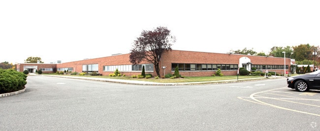
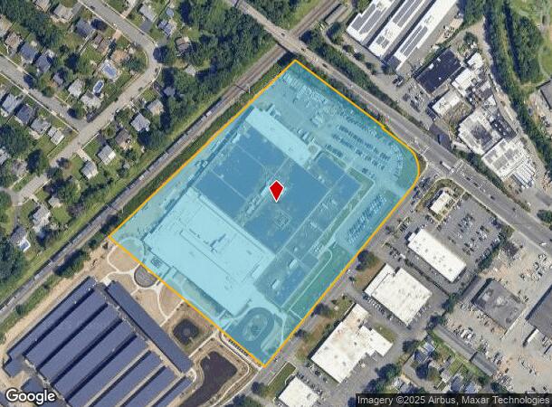
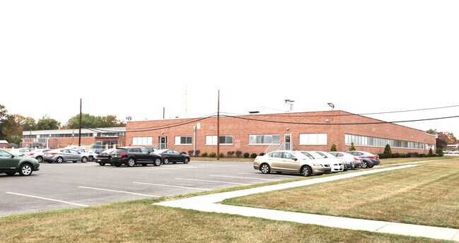
Property Record
30 Terminal Ave, Clark, NJ 07066

NEARBY LISTINGS FOR SALE OR LEASE
-
-
No Photo
-
-
-
-
-
-
View all Clark listings for sale on LoopNet.com
Property Detail
30 Terminal Ave
02-00058-0000-00005
Union
Industrialgeneral
New Jersey
X
5
34013C0150F
11.93 AC
2024
Central Union
2025
Northern New Jersey
036301
Newark, NJ-PA
DEMOGRAPHICS near 30 Terminal Ave
1 Mile
3 Mile
5 Mile
2024 Total Population
13,146
153,044
393,268
2029 Population
13,070
151,802
389,438
Pop Growth 2024-2029
(0.58%)
(0.81%)
(0.97%)
Average Age
42
41
41
2024 Total Households
4,804
56,325
138,865
HH Growth 2024-2029
(0.73%)
(0.92%)
(1.06%)
Median Household Inc
$136,332
$114,009
$108,907
Avg Household Size
2.70
2.70
2.70
2024 Avg HH Vehicles
2.00
2.00
2.00
Median Home Value
$609,264
$487,714
$456,667
Median Year Built
1958
1956
1958
Nearby Places
Map Layers
Map Styles
 Street
 Aerial
- Restaurants
- Banks
- Shops
- Fitness
- Groceries
PUBLIC TRANSPORTATION
COMMUTER RAIL
Garwood (Raritan Valley Line - NJ Transit Commuter Rail (NJ Transit))
DRIVE
WALK
Distance
Garwood (Raritan Valley Line - NJ Transit Commuter Rail (NJ Transit))
9 min
2.4 mi
Cranford (Raritan Valley Line - NJ Transit Commuter Rail (NJ Transit))
DRIVE
WALK
Distance
Cranford (Raritan Valley Line - NJ Transit Commuter Rail (NJ Transit))
8 min
2.6 mi
AIRPORT
Newark Liberty International
DRIVE
WALK
Distance
Newark Liberty International
22 min
14.1 mi
LaGuardia
DRIVE
WALK
Distance
LaGuardia
58 min
33.4 mi
John F Kennedy International
DRIVE
WALK
Distance
John F Kennedy International
63 min
37.4 mi
Freight Ports
New York Container Terminal
DRIVE
WALK
Distance
New York Container Terminal
21 min
10.2 mi
Nearby Properties
Address
Land Use
TOTAL SIZE
Lot Size
Zoning
Address
Land Use
TOTAL SIZE
Lot Size
Zoning
78.47 AC
Address
Land Use
TOTAL SIZE
Lot Size
Zoning
Address
Land Use
TOTAL SIZE
Lot Size
Zoning
10.11 AC
Address
Land Use
TOTAL SIZE
Lot Size
Zoning
8.43 AC
Address
Land Use
TOTAL SIZE
Lot Size
Zoning
29.03 AC
IL
Address
Land Use
TOTAL SIZE
Lot Size
Zoning
151.20 AC
O
Address
Land Use
TOTAL SIZE
Lot Size
Zoning
3,538 SF
112 AC
Address
Land Use
TOTAL SIZE
Lot Size
Zoning
9.42 AC
Address
Land Use
TOTAL SIZE
Lot Size
Zoning
19.90 AC
P
Address
Land Use
TOTAL SIZE
Lot Size
Zoning
182 SF
13.80 AC
Address
Land Use
TOTAL SIZE
Lot Size
Zoning
Address
Land Use
TOTAL SIZE
Lot Size
Zoning
10.15 AC
RA
Address
Land Use
TOTAL SIZE
Lot Size
Zoning
5,645 SF
91.16 AC
O
Address
Land Use
TOTAL SIZE
Lot Size
Zoning
4.13 AC
Address
Land Use
TOTAL SIZE
Lot Size
Zoning
3.87 AC
CG
Address
Land Use
TOTAL SIZE
Lot Size
Zoning
31,002 SF
3.64 AC
Address
Land Use
TOTAL SIZE
Lot Size
Zoning
Address
Land Use
TOTAL SIZE
Lot Size
Zoning
8.77 AC
Address
Land Use
TOTAL SIZE
Lot Size
Zoning
5.18 AC
Address
Land Use
TOTAL SIZE
Lot Size
Zoning
8.84 AC
Address
Land Use
TOTAL SIZE
Lot Size
Zoning
Address
Land Use
TOTAL SIZE
Lot Size
Zoning
10.16 AC
Address
Land Use
TOTAL SIZE
Lot Size
Zoning
7.63 AC
Address
Land Use
TOTAL SIZE
Lot Size
Zoning
188,800 SF
5.61 AC
Address
Land Use
TOTAL SIZE
Lot Size
Zoning
8.40 AC
Address
Land Use
TOTAL SIZE
Lot Size
Zoning
79,864 SF
6.58 AC
Address
Land Use
TOTAL SIZE
Lot Size
Zoning
15.85 AC
Address
Land Use
TOTAL SIZE
Lot Size
Zoning
9.98 AC
RA
Address
Land Use
TOTAL SIZE
Lot Size
Zoning
102,200 SF
6.68 AC
RA
The World's #1 Commercial Real Estate Marketplace
Connect with us
© 2026 CoStar Group
The information above has been obtained from sources believed reliable. While we do not doubt its accuracy we have not verified it and make no guarantee, warranty or representation about it. It is your responsibility to independently confirm its accuracy and completeness. Any projections, opinions, assumptions, or estimates used are for example only and do not represent the current or future performance of the property. The value of this transaction to you depends on tax and other factors which should be evaluated by your tax, financial, and legal advisors. You and your advisors should conduct a careful, independent investigation of the property to determine to your satisfaction the suitability of the property for your needs.