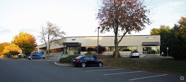
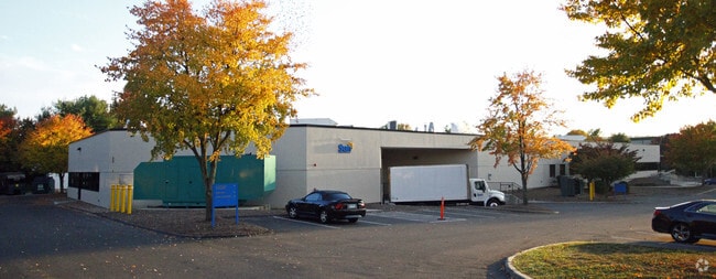
Property Record
30 Trefoil Dr, Trumbull, CT 06611

Save to a Folder
{{folder.Name}}
{{folder.ListingIds.length}} Properties
{{folder.ListingIds.length}} Property
Create a New Folder
Property Detail
30 Trefoil Dr
TRUM-000001D-000000-000042
FAIRFIELD
Industrialgeneral
Connecticut
IL2
42
AE The base floodplain where base flood elevations are provided. AE Zones are now used on new format FIRMs instead of A1-A30 Zones.
3.68 AC
2025
Trumbull
2025
Westchester/So Connecticut
090100
Bridgeport-Stamford-Danbury, CT
44,722 SF
NEARBY LISTINGS FOR SALE OR LEASE
DEMOGRAPHICS near 30 Trefoil Dr
1 mile
3 mile
5 mile
2025 Total Population
3,520
27,566
76,517
2030 Population
3,642
28,358
78,944
Pop Growth 2025-2030
+ 3.47%
+ 2.87%
+ 3.17%
Average Age
43
43
43
2025 Total Households
1,251
9,439
26,249
HH Growth 2025-2030
+ 3.52%
+ 2.91%
+ 3.19%
Median Household Inc
$182,281
$172,857
$160,386
Avg Household Size
2.80
2.80
2.80
2025 Avg HH Vehicles
2.00
2.00
2.00
Median Home Value
$634,786
$567,636
$539,509
Median Year Built
1977
1968
1968
Nearby Places
Map Layers
Map Styles
 Street
 Aerial
Layers
 Traffic
 Biking
Places
Listings with unknown addresses are not visible on the map
- Restaurants
- Banks
- Shops
- Fitness
- Groceries
PUBLIC TRANSPORTATION
AIRPORT
Tweed/New Haven
Drive
Walk
Distance
Tweed/New Haven
43 min
24.2 mi
Westchester County
Drive
Walk
Distance
Westchester County
58 min
39.1 mi
Freight Ports
Port of New Haven
Drive
Walk
Distance
Port of New Haven
38 min
21.3 mi
SALE & LEASE HISTORY
LISTING DATE
SALE/LEASE

Feb 22, 2021
For Sale
Nearby Properties
Address
Land Use
TOTAL SIZE
Lot Size
Zoning
Address
Land Use
TOTAL SIZE
Lot Size
Zoning
150,135 SF
9 AC
AA
Address
Land Use
TOTAL SIZE
Lot Size
Zoning
32.50 AC
AA
Address
Land Use
TOTAL SIZE
Lot Size
Zoning
17.76 AC
BC
Address
Land Use
TOTAL SIZE
Lot Size
Zoning
12.41 AC
BC
Address
Land Use
TOTAL SIZE
Lot Size
Zoning
114,000 SF
10.37 AC
IL2
Address
Land Use
TOTAL SIZE
Lot Size
Zoning
167,262 SF
26.01 AC
I3
Address
Land Use
TOTAL SIZE
Lot Size
Zoning
83,043 SF
19.97 AC
AA
Address
Land Use
TOTAL SIZE
Lot Size
Zoning
63,784 SF
4.60 AC
Address
Land Use
TOTAL SIZE
Lot Size
Zoning
110,520 SF
9.21 AC
IL2
Address
Land Use
TOTAL SIZE
Lot Size
Zoning
8.44 AC
B1
Address
Land Use
TOTAL SIZE
Lot Size
Zoning
16.96 AC
AA
Address
Land Use
TOTAL SIZE
Lot Size
Zoning
175 AC
RF3 R
Address
Land Use
TOTAL SIZE
Lot Size
Zoning
4,000 SF
238.88 AC
AAA
Address
Land Use
TOTAL SIZE
Lot Size
Zoning
9,796 SF
24.75 AC
I3
Address
Land Use
TOTAL SIZE
Lot Size
Zoning
52,786 SF
20 AC
A
Address
Land Use
TOTAL SIZE
Lot Size
Zoning
60,749 SF
7.25 AC
B1
Address
Land Use
TOTAL SIZE
Lot Size
Zoning
80,580 SF
6.49 AC
IL2
Address
Land Use
TOTAL SIZE
Lot Size
Zoning
61,723 SF
15.26 AC
RF1
Address
Land Use
TOTAL SIZE
Lot Size
Zoning
10.07 AC
RF1H
Address
Land Use
TOTAL SIZE
Lot Size
Zoning
40,849 SF
16.45 AC
R-1
Address
Land Use
TOTAL SIZE
Lot Size
Zoning
58,767 SF
32.50 AC
RF2
Address
Land Use
TOTAL SIZE
Lot Size
Zoning
86,611 SF
6.46 AC
IL
Address
Land Use
TOTAL SIZE
Lot Size
Zoning
53,439 SF
4.97 AC
IL2
Address
Land Use
TOTAL SIZE
Lot Size
Zoning
53,107 SF
5.02 AC
B2
Address
Land Use
TOTAL SIZE
Lot Size
Zoning
48,501 SF
5.84 AC
B1
Address
Land Use
TOTAL SIZE
Lot Size
Zoning
26,062 SF
3.12 AC
A
Address
Land Use
TOTAL SIZE
Lot Size
Zoning
33,280 SF
2.45 AC
RF1H
Address
Land Use
TOTAL SIZE
Lot Size
Zoning
58,455 SF
5.75 AC
I-1
Address
Land Use
TOTAL SIZE
Lot Size
Zoning
4,470 SF
15.90 AC
AA
Address
Land Use
TOTAL SIZE
Lot Size
Zoning
3,424 SF
6.99 AC
LOR
The World's #1 Commercial Real Estate Marketplace
Connect with us
© 2026 CoStar Group
The information above has been obtained from sources believed reliable. While we do not doubt its accuracy we have not verified it and make no guarantee, warranty or representation about it. It is your responsibility to independently confirm its accuracy and completeness. Any projections, opinions, assumptions, or estimates used are for example only and do not represent the current or future performance of the property. The value of this transaction to you depends on tax and other factors which should be evaluated by your tax, financial, and legal advisors. You and your advisors should conduct a careful, independent investigation of the property to determine to your satisfaction the suitability of the property for your needs.