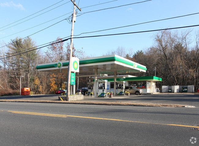
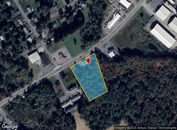
Property Record
30 W State St, Granby, MA 01033

NEARBY LISTINGS FOR SALE OR LEASE
Property Detail
30 W State St
Amherst Town-Northampton, MA
Hampshire
GRAN-000004AA000000-000002
Massachusetts
Gasolinefuelbulkstorage
2
2025
2.17 AC
2025
Hampshire County
820900
Hartford
1,644 SF
DEMOGRAPHICS near 30 W State St
1 Mile
3 Mile
5 Mile
2024 Total Population
2,749
22,484
67,431
2029 Population
2,175
19,077
62,506
Pop Growth 2024-2029
(20.88%)
(15.15%)
(7.30%)
Average Age
46
42
41
2024 Total Households
1,146
8,710
27,255
HH Growth 2024-2029
(21.55%)
(16.95%)
(7.90%)
Median Household Inc
$110,188
$79,336
$58,916
Avg Household Size
2.30
2.20
2.30
2024 Avg HH Vehicles
2.00
2.00
2.00
Median Home Value
$299,562
$297,434
$270,429
Median Year Built
1963
1961
1957
Nearby Places
Map Layers
Map Styles
 Street
 Aerial
- Restaurants
- Banks
- Shops
- Fitness
- Groceries
PUBLIC TRANSPORTATION
COMMUTER RAIL
DRIVE
WALK
Distance
10 min
4.6 mi
AIRPORT
Bradley International
DRIVE
WALK
Distance
Bradley International
47 min
25.4 mi
Nearby Properties
Address
Land Use
TOTAL SIZE
Lot Size
Zoning
Address
Land Use
TOTAL SIZE
Lot Size
Zoning
16.30 AC
RA2
Address
Land Use
TOTAL SIZE
Lot Size
Zoning
4.50 AC
RA2
Address
Land Use
TOTAL SIZE
Lot Size
Zoning
52 AC
RA1
Address
Land Use
TOTAL SIZE
Lot Size
Zoning
26.68 AC
110
Address
Land Use
TOTAL SIZE
Lot Size
Zoning
9 AC
RA2
Address
Land Use
TOTAL SIZE
Lot Size
Zoning
4.04 AC
107
Address
Land Use
TOTAL SIZE
Lot Size
Zoning
26.35 AC
RA2
Address
Land Use
TOTAL SIZE
Lot Size
Zoning
64,638 SF
9.26 AC
RA2
Address
Land Use
TOTAL SIZE
Lot Size
Zoning
80,393 SF
1.71 AC
111
Address
Land Use
TOTAL SIZE
Lot Size
Zoning
3.30 AC
RA2
Address
Land Use
TOTAL SIZE
Lot Size
Zoning
152,380 SF
11.36 AC
110
Address
Land Use
TOTAL SIZE
Lot Size
Zoning
61,808 SF
8.53 AC
RA2
Address
Land Use
TOTAL SIZE
Lot Size
Zoning
291,714 SF
35.75 AC
110
Address
Land Use
TOTAL SIZE
Lot Size
Zoning
144,384 SF
35.87 AC
RA2
Address
Land Use
TOTAL SIZE
Lot Size
Zoning
2.44 AC
RA2
Address
Land Use
TOTAL SIZE
Lot Size
Zoning
16.36 AC
RA1
Address
Land Use
TOTAL SIZE
Lot Size
Zoning
17.68 AC
IGD
Address
Land Use
TOTAL SIZE
Lot Size
Zoning
1.09 AC
RA2
Address
Land Use
TOTAL SIZE
Lot Size
Zoning
3 AC
107
Address
Land Use
TOTAL SIZE
Lot Size
Zoning
1,361.42 AC
Address
Land Use
TOTAL SIZE
Lot Size
Zoning
2.20 AC
RA2
Address
Land Use
TOTAL SIZE
Lot Size
Zoning
6.20 AC
RA2
Address
Land Use
TOTAL SIZE
Lot Size
Zoning
138,000 SF
11.17 AC
110
Address
Land Use
TOTAL SIZE
Lot Size
Zoning
55,376 SF
3.20 AC
RA1
Address
Land Use
TOTAL SIZE
Lot Size
Zoning
13.10 AC
RA1
Address
Land Use
TOTAL SIZE
Lot Size
Zoning
99,205 SF
12.30 AC
110
Address
Land Use
TOTAL SIZE
Lot Size
Zoning
40,600 SF
3.13 AC
107
Address
Land Use
TOTAL SIZE
Lot Size
Zoning
4,180 SF
3.50 AC
RA1
Address
Land Use
TOTAL SIZE
Lot Size
Zoning
13.29 AC
IB
Address
Land Use
TOTAL SIZE
Lot Size
Zoning
130,090 SF
5.61 AC
IA0
The World's #1 Commercial Real Estate Marketplace
Connect with us
© 2026 CoStar Group
The information above has been obtained from sources believed reliable. While we do not doubt its accuracy we have not verified it and make no guarantee, warranty or representation about it. It is your responsibility to independently confirm its accuracy and completeness. Any projections, opinions, assumptions, or estimates used are for example only and do not represent the current or future performance of the property. The value of this transaction to you depends on tax and other factors which should be evaluated by your tax, financial, and legal advisors. You and your advisors should conduct a careful, independent investigation of the property to determine to your satisfaction the suitability of the property for your needs.