Property Record
30 Washburn Rd, East Freetown, MA 02717
NEARBY LISTINGS FOR SALE OR LEASE
-
-
View all East Freetown listings for sale on LoopNet.com
Property Detail
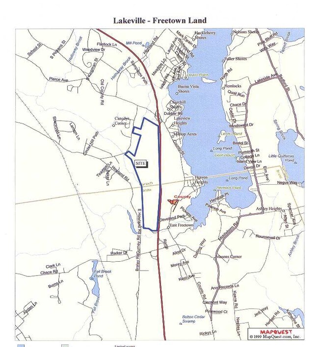
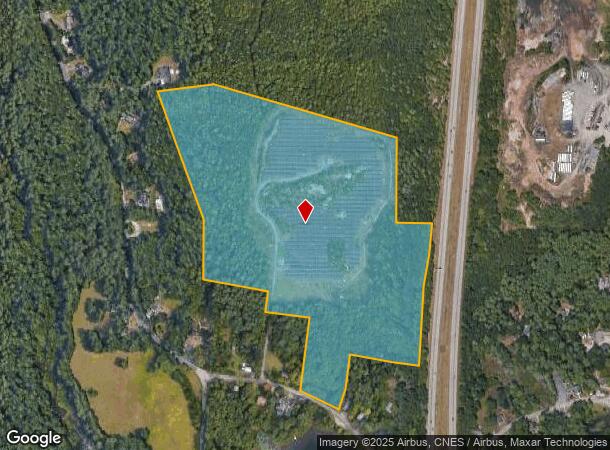
30 Washburn Rd
FREE-000227-000000-000020
Bristol
Privateutilityelectricwatergasnuclearsolarwindetc
Massachusetts
AE
40.10 AC
25005C0289G
Attleboro/New Bedford
2025
Boston
2025
Providence-Warwick, RI-MA
617102
DEMOGRAPHICS near 30 Washburn Rd
1 Mile
3 Mile
5 Mile
2024 Total Population
947
9,000
25,126
2029 Population
936
8,997
25,101
Pop Growth 2024-2029
(1.16%)
(0.03%)
(0.10%)
Average Age
43
43
43
2024 Total Households
349
3,314
9,367
HH Growth 2024-2029
(1.15%)
(0.03%)
(0.15%)
Median Household Inc
$110,483
$116,305
$110,788
Avg Household Size
2.70
2.70
2.70
2024 Avg HH Vehicles
2.00
2.00
2.00
Median Home Value
$467,105
$462,005
$433,550
Median Year Built
1975
1977
1978
Nearby Places
Map Layers
Map Styles
 Street
 Aerial
- Restaurants
- Banks
- Shops
- Fitness
- Groceries
PUBLIC TRANSPORTATION
AIRPORT
Rhode Island Tf Green International
DRIVE
WALK
Distance
Rhode Island Tf Green International
60 min
36.6 mi
Freight Ports
Port of New Bedford Harbor
DRIVE
WALK
Distance
Port of New Bedford Harbor
19 min
11.4 mi
SALE & LEASE HISTORY
LISTING DATE
SALE/LEASE

Sep 24, 2016
For Sale
Nearby Properties
Address
Land Use
TOTAL SIZE
Lot Size
Zoning
Address
Land Use
TOTAL SIZE
Lot Size
Zoning
75 AC
A/R
Address
Land Use
TOTAL SIZE
Lot Size
Zoning
97,935 SF
50 AC
R
Address
Land Use
TOTAL SIZE
Lot Size
Zoning
31.14 AC
R
Address
Land Use
TOTAL SIZE
Lot Size
Zoning
2,834 SF
41.81 AC
OSR
Address
Land Use
TOTAL SIZE
Lot Size
Zoning
5,500 SF
152 AC
G
Address
Land Use
TOTAL SIZE
Lot Size
Zoning
6.34 AC
RA
Address
Land Use
TOTAL SIZE
Lot Size
Zoning
51,243 SF
8.51 AC
RA
Address
Land Use
TOTAL SIZE
Lot Size
Zoning
71 AC
R
Address
Land Use
TOTAL SIZE
Lot Size
Zoning
52,588 SF
3.67 AC
RA
Address
Land Use
TOTAL SIZE
Lot Size
Zoning
12.08 AC
Address
Land Use
TOTAL SIZE
Lot Size
Zoning
Address
Land Use
TOTAL SIZE
Lot Size
Zoning
613 AC
Address
Land Use
TOTAL SIZE
Lot Size
Zoning
13,449 SF
4.70 AC
Address
Land Use
TOTAL SIZE
Lot Size
Zoning
19.79 AC
I
Address
Land Use
TOTAL SIZE
Lot Size
Zoning
13,247 SF
0.74 AC
MUB
Address
Land Use
TOTAL SIZE
Lot Size
Zoning
3.40 AC
B
Address
Land Use
TOTAL SIZE
Lot Size
Zoning
16.92 AC
G
Address
Land Use
TOTAL SIZE
Lot Size
Zoning
43,992 SF
6.30 AC
I
Address
Land Use
TOTAL SIZE
Lot Size
Zoning
56,195 SF
7.20 AC
I
Address
Land Use
TOTAL SIZE
Lot Size
Zoning
270.39 AC
Address
Land Use
TOTAL SIZE
Lot Size
Zoning
5.51 AC
B
Address
Land Use
TOTAL SIZE
Lot Size
Zoning
6,480 SF
99.46 AC
G
Address
Land Use
TOTAL SIZE
Lot Size
Zoning
8,185 SF
10.01 AC
Address
Land Use
TOTAL SIZE
Lot Size
Zoning
11.35 AC
G
Address
Land Use
TOTAL SIZE
Lot Size
Zoning
16,094 SF
7.23 AC
R
Address
Land Use
TOTAL SIZE
Lot Size
Zoning
2,646 SF
40 AC
G
Address
Land Use
TOTAL SIZE
Lot Size
Zoning
5.54 AC
I
Address
Land Use
TOTAL SIZE
Lot Size
Zoning
4.80 AC
RA
Address
Land Use
TOTAL SIZE
Lot Size
Zoning
3,088 SF
6.76 AC
B
The World's #1 Commercial Real Estate Marketplace
Connect with us
© 2026 CoStar Group
The information above has been obtained from sources believed reliable. While we do not doubt its accuracy we have not verified it and make no guarantee, warranty or representation about it. It is your responsibility to independently confirm its accuracy and completeness. Any projections, opinions, assumptions, or estimates used are for example only and do not represent the current or future performance of the property. The value of this transaction to you depends on tax and other factors which should be evaluated by your tax, financial, and legal advisors. You and your advisors should conduct a careful, independent investigation of the property to determine to your satisfaction the suitability of the property for your needs.