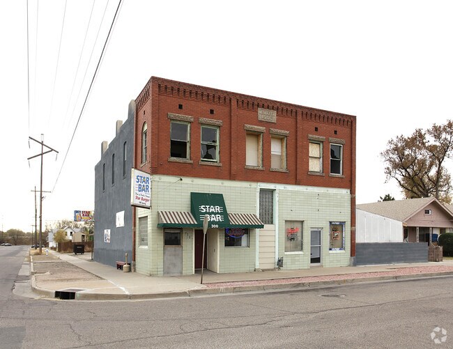
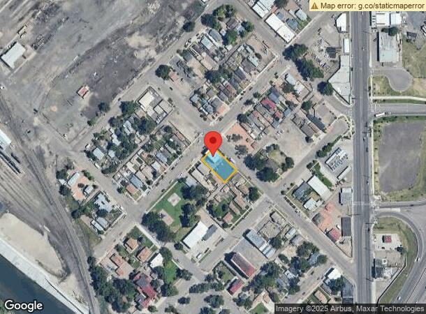
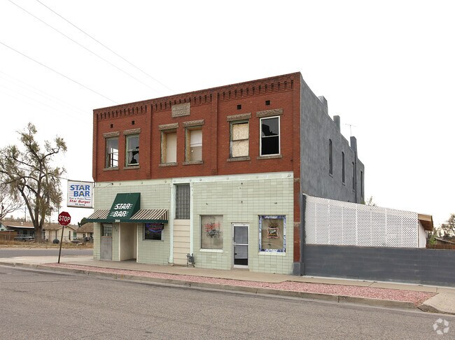
Property Record
300 Spring St, Pueblo, CO 81003
NEARBY LISTINGS FOR SALE OR LEASE
Property Detail
300 Spring St
Pueblo, CO
Com-The Grove
1-5-01-1-42-005
LOTS 14-15-16 BLK 118 SOUTH PUEBLO
Commercialacreage
Pueblo
X
Colorado
08101C0513D
14-15
2024
0.24 AC
2024
Colorado East Area
003500
Other Market Areas
5,621 SF
DEMOGRAPHICS near 300 Spring St
1 Mile
3 Mile
5 Mile
2024 Total Population
8,963
72,991
121,988
2029 Population
9,163
74,787
125,049
Pop Growth 2024-2029
+ 2.23%
+ 2.46%
+ 2.51%
Average Age
39
40
40
2024 Total Households
3,379
30,095
49,912
HH Growth 2024-2029
+ 2.75%
+ 2.56%
+ 2.64%
Median Household Inc
$29,585
$40,340
$50,333
Avg Household Size
2.10
2.30
2.30
2024 Avg HH Vehicles
1.00
2.00
2.00
Median Home Value
$149,410
$182,028
$228,437
Median Year Built
1947
1955
1967
Nearby Places
- Restaurants
- Banks
- Shops
- Fitness
- Groceries
SALE & LEASE HISTORY
LISTING DATE
SALE/LEASE

Sep 24, 2016
For Sale
Nov 07, 2016
For Sale
Mar 12, 2019
For Sale
Nearby Properties
Address
Land Use
TOTAL SIZE
Lot Size
Zoning
Address
Land Use
TOTAL SIZE
Lot Size
Zoning
17,710 SF
49.97 AC
Address
Land Use
TOTAL SIZE
Lot Size
Zoning
486,484 SF
3.75 AC
R5:RES/MUL
Address
Land Use
TOTAL SIZE
Lot Size
Zoning
168,237 SF
3.69 AC
S-1
Address
Land Use
TOTAL SIZE
Lot Size
Zoning
53,269 SF
4.51 AC
Address
Land Use
TOTAL SIZE
Lot Size
Zoning
65,508 SF
3.18 AC
Address
Land Use
TOTAL SIZE
Lot Size
Zoning
4,492,279 SF
488.39 AC
Address
Land Use
TOTAL SIZE
Lot Size
Zoning
122,704 SF
2.72 AC
B4:COMM/RE
Address
Land Use
TOTAL SIZE
Lot Size
Zoning
54,250 SF
2.06 AC
B4:COMM/RE
Address
Land Use
TOTAL SIZE
Lot Size
Zoning
79,394 SF
5.57 AC
R5:RES/MUL
Address
Land Use
TOTAL SIZE
Lot Size
Zoning
71,345 SF
5.17 AC
Address
Land Use
TOTAL SIZE
Lot Size
Zoning
71,936 SF
3.43 AC
R4:RES/MUL
Address
Land Use
TOTAL SIZE
Lot Size
Zoning
42,289 SF
0.54 AC
B4:COMM/RE
Address
Land Use
TOTAL SIZE
Lot Size
Zoning
47,007 SF
8.79 AC
Address
Land Use
TOTAL SIZE
Lot Size
Zoning
40,986 SF
0.65 AC
R5:RES/MUL
Address
Land Use
TOTAL SIZE
Lot Size
Zoning
26,255 SF
2.08 AC
Address
Land Use
TOTAL SIZE
Lot Size
Zoning
56,088 SF
4 AC
Address
Land Use
TOTAL SIZE
Lot Size
Zoning
94,278 SF
2.11 AC
R-5
Address
Land Use
TOTAL SIZE
Lot Size
Zoning
25,172 SF
1.42 AC
R5:RES/MUL
Address
Land Use
TOTAL SIZE
Lot Size
Zoning
33,866 SF
3.34 AC
Address
Land Use
TOTAL SIZE
Lot Size
Zoning
1,070,193 SF
43.08 AC
R5:RES/MUL
Address
Land Use
TOTAL SIZE
Lot Size
Zoning
27,682 SF
1.85 AC
S-1
Address
Land Use
TOTAL SIZE
Lot Size
Zoning
25,714 SF
17.61 AC
Address
Land Use
TOTAL SIZE
Lot Size
Zoning
23,025 SF
1.21 AC
R5:RES/MUL
Address
Land Use
TOTAL SIZE
Lot Size
Zoning
45,219 SF
4.46 AC
Address
Land Use
TOTAL SIZE
Lot Size
Zoning
13,178 SF
1.10 AC
R2:RES/1 F
Address
Land Use
TOTAL SIZE
Lot Size
Zoning
84,872 SF
0.76 AC
B4:COMM/RE
Address
Land Use
TOTAL SIZE
Lot Size
Zoning
35,530 SF
0.55 AC
R-4
Address
Land Use
TOTAL SIZE
Lot Size
Zoning
35,530 SF
0.54 AC
S1:SPC/PUB
Address
Land Use
TOTAL SIZE
Lot Size
Zoning
117,715 SF
3.58 AC
Address
Land Use
TOTAL SIZE
Lot Size
Zoning
22,611 SF
6.85 AC
S1:SPC/PUB
The World's #1 Commercial Real Estate Marketplace
Connect with us
© 2025 CoStar Group
The information above has been obtained from sources believed reliable. While we do not doubt its accuracy we have not verified it and make no guarantee, warranty or representation about it. It is your responsibility to independently confirm its accuracy and completeness. Any projections, opinions, assumptions, or estimates used are for example only and do not represent the current or future performance of the property. The value of this transaction to you depends on tax and other factors which should be evaluated by your tax, financial, and legal advisors. You and your advisors should conduct a careful, independent investigation of the property to determine to your satisfaction the suitability of the property for your needs.