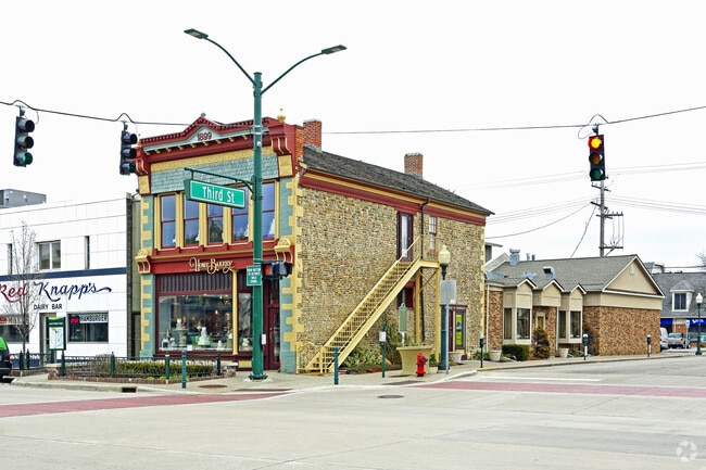
Property Record
300 S Main St, Rochester, MI 48307

NEARBY LISTINGS FOR SALE OR LEASE
Property Detail
300 S Main St
Detroit-Warren-Dearborn, MI
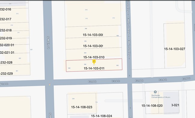
Original Plat
15-14-103-011
T3N, R11E, SEC 14 ORIGINAL PLAT S 1/2 OF LOT 14
Officebuilding
Oakland
X
Michigan
26125C0392F
14
2024
0.10 AC
2025
Rochester
191200
Detroit
4,850 SF
DEMOGRAPHICS near 300 S Main St
1 Mile
3 Mile
5 Mile
2024 Total Population
10,616
69,670
157,558
2029 Population
10,572
68,996
156,171
Pop Growth 2024-2029
(0.41%)
(0.97%)
(0.88%)
Average Age
41
42
42
2024 Total Households
4,973
27,878
61,993
HH Growth 2024-2029
(0.36%)
(0.92%)
(0.84%)
Median Household Inc
$95,074
$107,079
$103,734
Avg Household Size
2.10
2.40
2.40
2024 Avg HH Vehicles
2.00
2.00
2.00
Median Home Value
$372,110
$363,677
$362,005
Median Year Built
1976
1982
1984
Nearby Places
Map Layers
Map Styles
 Street
 Aerial
- Restaurants
- Banks
- Shops
- Fitness
- Groceries
PUBLIC TRANSPORTATION
AIRPORT
Windsor International
DRIVE
WALK
Distance
Windsor International
59 min
35.6 mi
Bishop International
DRIVE
WALK
Distance
Bishop International
65 min
44.9 mi
Detroit Metro Wayne County
DRIVE
WALK
Distance
Detroit Metro Wayne County
63 min
45.1 mi
Nearby Properties
Address
Land Use
TOTAL SIZE
Lot Size
Zoning
Address
Land Use
TOTAL SIZE
Lot Size
Zoning
444,087 SF
83.19 AC
II
Address
Land Use
TOTAL SIZE
Lot Size
Zoning
3,529 SF
29.19 AC
BI
Address
Land Use
TOTAL SIZE
Lot Size
Zoning
57.84 AC
AV
Address
Land Use
TOTAL SIZE
Lot Size
Zoning
389,465 SF
30.24 AC
II
Address
Land Use
TOTAL SIZE
Lot Size
Zoning
Address
Land Use
TOTAL SIZE
Lot Size
Zoning
195,413 SF
4.43 AC
Address
Land Use
TOTAL SIZE
Lot Size
Zoning
35.60 AC
R-12
Address
Land Use
TOTAL SIZE
Lot Size
Zoning
22.09 AC
AI
Address
Land Use
TOTAL SIZE
Lot Size
Zoning
134,904 SF
5 AC
Address
Land Use
TOTAL SIZE
Lot Size
Zoning
119.30 AC
Address
Land Use
TOTAL SIZE
Lot Size
Zoning
21.52 AC
AI
Address
Land Use
TOTAL SIZE
Lot Size
Zoning
Address
Land Use
TOTAL SIZE
Lot Size
Zoning
51.98 AC
MHP
Address
Land Use
TOTAL SIZE
Lot Size
Zoning
62,495 SF
2.49 AC
MM
Address
Land Use
TOTAL SIZE
Lot Size
Zoning
89,450 SF
0.41 AC
BI
Address
Land Use
TOTAL SIZE
Lot Size
Zoning
26.25 AC
AI
Address
Land Use
TOTAL SIZE
Lot Size
Zoning
96,460 SF
17.50 AC
Address
Land Use
TOTAL SIZE
Lot Size
Zoning
55,651 SF
23.39 AC
II
Address
Land Use
TOTAL SIZE
Lot Size
Zoning
191.40 AC
AI
Address
Land Use
TOTAL SIZE
Lot Size
Zoning
112,300 SF
25.04 AC
Address
Land Use
TOTAL SIZE
Lot Size
Zoning
139,853 SF
11.76 AC
BI
Address
Land Use
TOTAL SIZE
Lot Size
Zoning
10.88 AC
AI
Address
Land Use
TOTAL SIZE
Lot Size
Zoning
141,321 SF
9.03 AC
AI
The World's #1 Commercial Real Estate Marketplace
Connect with us
© 2026 CoStar Group
The information above has been obtained from sources believed reliable. While we do not doubt its accuracy we have not verified it and make no guarantee, warranty or representation about it. It is your responsibility to independently confirm its accuracy and completeness. Any projections, opinions, assumptions, or estimates used are for example only and do not represent the current or future performance of the property. The value of this transaction to you depends on tax and other factors which should be evaluated by your tax, financial, and legal advisors. You and your advisors should conduct a careful, independent investigation of the property to determine to your satisfaction the suitability of the property for your needs.