Property Record
300 Broadacres Dr, Bloomfield, NJ 07003


Save to a Folder
{{folder.Name}}
{{folder.ListingIds.length}} Properties
{{folder.ListingIds.length}} Property
Create a New Folder
Current Lease Availabilities
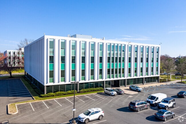
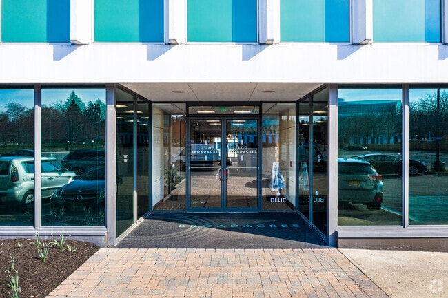
Property Detail
300 Broadacres Dr
Newark, NJ
3.536 AC SOLD W/44+1231-46+51
02-01233-0000-00045
Essex
Officebuilding
New Jersey
RO
45
B and X Area of moderate flood hazard, usually the area between the limits of the 100-year and 500-year floods.
3.54 AC
2025
Bloomfield/GSP
2026
Northern New Jersey
014800
NEARBY LISTINGS FOR SALE OR LEASE
DEMOGRAPHICS near 300 Broadacres Dr
1 mile
3 mile
5 mile
2025 Total Population
18,281
208,559
656,270
2030 Population
19,156
216,202
673,574
Pop Growth 2025-2030
+ 4.79%
+ 3.66%
+ 2.64%
Average Age
42
41
40
2025 Total Households
6,438
77,570
238,700
HH Growth 2025-2030
+ 4.74%
+ 3.86%
+ 2.82%
Median Household Inc
$186,306
$120,782
$94,254
Avg Household Size
2.80
2.60
2.70
2025 Avg HH Vehicles
2.00
2.00
2.00
Median Home Value
$626,541
$530,118
$494,272
Median Year Built
1950
1953
1953
Nearby Places
Map Layers
Map Styles
 Street
 Aerial
Layers
 Traffic
 Biking
Places
Listings with unknown addresses are not visible on the map
- Restaurants
- Banks
- Shops
- Fitness
- Groceries
PUBLIC TRANSPORTATION
COMMUTER RAIL
Upper Montclair (Montclair-Boonton Line - NJ Transit Commuter Rail (NJ Transit))
Drive
Walk
Distance
Upper Montclair (Montclair-Boonton Line - NJ Transit Commuter Rail (NJ Transit))
5 min
1.7 mi
Mountain Avenue (Montclair-Boonton Line - NJ Transit Commuter Rail (NJ Transit))
Drive
Walk
Distance
Mountain Avenue (Montclair-Boonton Line - NJ Transit Commuter Rail (NJ Transit))
5 min
2.2 mi
AIRPORT
Newark Liberty International
Drive
Walk
Distance
Newark Liberty International
21 min
16.7 mi
LaGuardia
Drive
Walk
Distance
LaGuardia
41 min
23.2 mi
John F Kennedy International
Drive
Walk
Distance
John F Kennedy International
49 min
31.2 mi
Freight Ports
Maher Terminal
Drive
Walk
Distance
Maher Terminal
28 min
16.5 mi
Nearby Properties
Address
Land Use
TOTAL SIZE
Lot Size
Zoning
Address
Land Use
TOTAL SIZE
Lot Size
Zoning
5 AC
H
Address
Land Use
TOTAL SIZE
Lot Size
Zoning
28.33 AC
Address
Land Use
TOTAL SIZE
Lot Size
Zoning
1,589 SF
0.22 AC
R4
Address
Land Use
TOTAL SIZE
Lot Size
Zoning
12.54 AC
OPRP
Address
Land Use
TOTAL SIZE
Lot Size
Zoning
0.24 AC
R4
Address
Land Use
TOTAL SIZE
Lot Size
Zoning
1.12 AC
M-O
Address
Land Use
TOTAL SIZE
Lot Size
Zoning
20.43 AC
Address
Land Use
TOTAL SIZE
Lot Size
Zoning
Address
Land Use
TOTAL SIZE
Lot Size
Zoning
3.26 AC
PR
Address
Land Use
TOTAL SIZE
Lot Size
Zoning
14.54 AC
R-MF
Address
Land Use
TOTAL SIZE
Lot Size
Zoning
137,286 SF
11.36 AC
M-2
Address
Land Use
TOTAL SIZE
Lot Size
Zoning
1.50 AC
RA
Address
Land Use
TOTAL SIZE
Lot Size
Zoning
1.95 AC
RA
Address
Land Use
TOTAL SIZE
Lot Size
Zoning
3.55 AC
Address
Land Use
TOTAL SIZE
Lot Size
Zoning
9.98 AC
R-1
Address
Land Use
TOTAL SIZE
Lot Size
Zoning
13.82 AC
O
Address
Land Use
TOTAL SIZE
Lot Size
Zoning
7.22 AC
M-3
Address
Land Use
TOTAL SIZE
Lot Size
Zoning
19.46 AC
Address
Land Use
TOTAL SIZE
Lot Size
Zoning
4.08 AC
Address
Land Use
TOTAL SIZE
Lot Size
Zoning
9.38 AC
B-A
Address
Land Use
TOTAL SIZE
Lot Size
Zoning
25.80 AC
P
Address
Land Use
TOTAL SIZE
Lot Size
Zoning
4.09 AC
M-O
Address
Land Use
TOTAL SIZE
Lot Size
Zoning
17.90 AC
R-G
Address
Land Use
TOTAL SIZE
Lot Size
Zoning
12.52 AC
Address
Land Use
TOTAL SIZE
Lot Size
Zoning
1,063 SF
14.08 AC
C-1
Address
Land Use
TOTAL SIZE
Lot Size
Zoning
21.80 AC
R-A3
Address
Land Use
TOTAL SIZE
Lot Size
Zoning
129,312 SF
11.80 AC
M-0
Address
Land Use
TOTAL SIZE
Lot Size
Zoning
Address
Land Use
TOTAL SIZE
Lot Size
Zoning
1,832 SF
2.18 AC
R3
Address
Land Use
TOTAL SIZE
Lot Size
Zoning
5.25 AC
M-1
The World's #1 Commercial Real Estate Marketplace
Connect with us
© 2026 CoStar Group
The information above has been obtained from sources believed reliable. While we do not doubt its accuracy we have not verified it and make no guarantee, warranty or representation about it. It is your responsibility to independently confirm its accuracy and completeness. Any projections, opinions, assumptions, or estimates used are for example only and do not represent the current or future performance of the property. The value of this transaction to you depends on tax and other factors which should be evaluated by your tax, financial, and legal advisors. You and your advisors should conduct a careful, independent investigation of the property to determine to your satisfaction the suitability of the property for your needs.