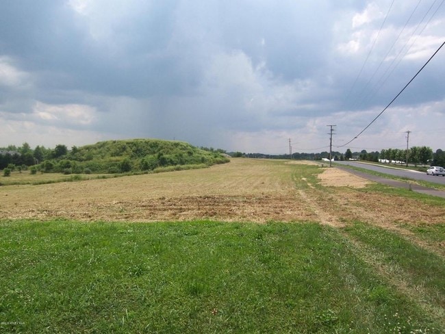
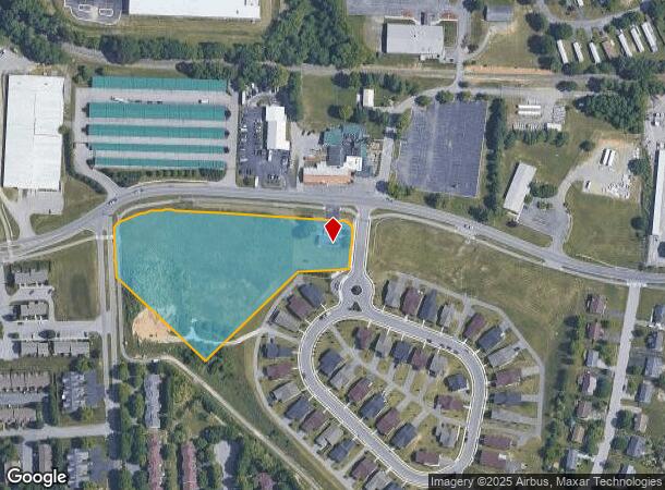
Property Record
300 Cambria St Nw, Christiansburg, VA 24073
NEARBY LISTINGS FOR SALE OR LEASE
-
-
No Photo
-
-
View all Christiansburg listings for sale on LoopNet.com
Property Detail
300 Cambria St Nw
Blacksburg-Christiansburg-Radford, VA
Lions Gate
140063
LIONS GATE PH II TRACT A
Commercialnec
Montgomery
X
Virginia
51121C0143C
a
2025
4.07 AC
2025
Blacksburg & Wytheville
021102
Other Market Areas
1,680 SF
DEMOGRAPHICS near 300 Cambria St Nw
1 Mile
3 Mile
5 Mile
2024 Total Population
5,316
24,984
44,216
2029 Population
5,241
24,668
43,734
Pop Growth 2024-2029
(1.41%)
(1.26%)
(1.09%)
Average Age
39
40
39
2024 Total Households
2,262
10,814
19,220
HH Growth 2024-2029
(1.33%)
(1.27%)
(1.09%)
Median Household Inc
$88,263
$65,273
$59,283
Avg Household Size
2.30
2.20
2.20
2024 Avg HH Vehicles
2.00
2.00
2.00
Median Home Value
$231,269
$238,422
$252,287
Median Year Built
1997
1991
1988
Nearby Places
Map Layers
Map Styles
 Street
 Aerial
- Restaurants
- Banks
- Shops
- Fitness
- Groceries
PUBLIC TRANSPORTATION
AIRPORT
Roanoke/Blacksburg Regional (Woodrum Field)
DRIVE
WALK
Distance
Roanoke/Blacksburg Regional (Woodrum Field)
49 min
34.5 mi
Freight Ports
Virginia Port Authority - Richmond
DRIVE
WALK
Distance
Virginia Port Authority - Richmond
251 min
218.4 mi
SALE & LEASE HISTORY
LISTING DATE
SALE/LEASE

Sep 24, 2016
For Sale
Nearby Properties
Address
Land Use
TOTAL SIZE
Lot Size
Zoning
Address
Land Use
TOTAL SIZE
Lot Size
Zoning
190,465 SF
30.37 AC
R1
Address
Land Use
TOTAL SIZE
Lot Size
Zoning
96,768 SF
20.18 AC
RM1
Address
Land Use
TOTAL SIZE
Lot Size
Zoning
189,259 SF
31.06 AC
R&D
Address
Land Use
TOTAL SIZE
Lot Size
Zoning
33.70 AC
A1
Address
Land Use
TOTAL SIZE
Lot Size
Zoning
151,388 SF
18.29 AC
B3
Address
Land Use
TOTAL SIZE
Lot Size
Zoning
151,450 SF
13.88 AC
B3
Address
Land Use
TOTAL SIZE
Lot Size
Zoning
538,247 SF
54.60 AC
B3
Address
Land Use
TOTAL SIZE
Lot Size
Zoning
66,896 SF
4 AC
O
Address
Land Use
TOTAL SIZE
Lot Size
Zoning
200,004 SF
23.11 AC
B3
Address
Land Use
TOTAL SIZE
Lot Size
Zoning
147,552 SF
4.54 AC
I2
Address
Land Use
TOTAL SIZE
Lot Size
Zoning
54,510 SF
10.43 AC
IN
Address
Land Use
TOTAL SIZE
Lot Size
Zoning
3.86 AC
Address
Land Use
TOTAL SIZE
Lot Size
Zoning
124,503 SF
11.30 AC
B3
Address
Land Use
TOTAL SIZE
Lot Size
Zoning
49,525 SF
11.07 AC
B3
Address
Land Use
TOTAL SIZE
Lot Size
Zoning
108,510 SF
11.89 AC
B3
Address
Land Use
TOTAL SIZE
Lot Size
Zoning
7.95 AC
A
Address
Land Use
TOTAL SIZE
Lot Size
Zoning
281,082 SF
33.56 AC
I2
Address
Land Use
TOTAL SIZE
Lot Size
Zoning
99,595 SF
11.92 AC
B3
Address
Land Use
TOTAL SIZE
Lot Size
Zoning
128,416 SF
17.24 AC
B3
Address
Land Use
TOTAL SIZE
Lot Size
Zoning
46.46 AC
GB
Address
Land Use
TOTAL SIZE
Lot Size
Zoning
61,328 SF
2.33 AC
B3
Address
Land Use
TOTAL SIZE
Lot Size
Zoning
52,475 SF
19.11 AC
B3
Address
Land Use
TOTAL SIZE
Lot Size
Zoning
Address
Land Use
TOTAL SIZE
Lot Size
Zoning
40,363 SF
12.30 AC
B3
Address
Land Use
TOTAL SIZE
Lot Size
Zoning
423,796 SF
53.92 AC
I2
Address
Land Use
TOTAL SIZE
Lot Size
Zoning
133,000 SF
9.67 AC
I2
Address
Land Use
TOTAL SIZE
Lot Size
Zoning
43,200 SF
2.30 AC
B3
Address
Land Use
TOTAL SIZE
Lot Size
Zoning
48,678 SF
0.03 AC
A1
Address
Land Use
TOTAL SIZE
Lot Size
Zoning
1,712 SF
131.68 AC
A1
Address
Land Use
TOTAL SIZE
Lot Size
Zoning
95,224 SF
7.96 AC
B3
The World's #1 Commercial Real Estate Marketplace
Connect with us
© 2025 CoStar Group
The information above has been obtained from sources believed reliable. While we do not doubt its accuracy we have not verified it and make no guarantee, warranty or representation about it. It is your responsibility to independently confirm its accuracy and completeness. Any projections, opinions, assumptions, or estimates used are for example only and do not represent the current or future performance of the property. The value of this transaction to you depends on tax and other factors which should be evaluated by your tax, financial, and legal advisors. You and your advisors should conduct a careful, independent investigation of the property to determine to your satisfaction the suitability of the property for your needs.