Property Record
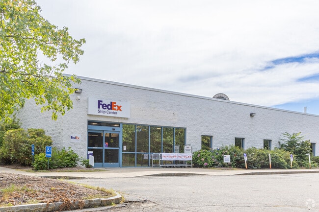
300 Century Dr, West Boylston, MA 01583


Current Lease Availabilities
NEARBY LISTINGS FOR SALE OR LEASE
Property Detail
300 Century Dr
Industrialgeneral
Worcester
X
Massachusetts
25027C0610F
11.99 AC
2025
Worcester Metro
2025
Boston
729100
Worcester, MA-CT
97,797 SF
WBOY-000182-000013
DEMOGRAPHICS near 300 Century Dr
1 Mile
3 Mile
5 Mile
2024 Total Population
7,811
62,066
192,711
2029 Population
7,787
61,423
190,885
Pop Growth 2024-2029
(0.31%)
(1.04%)
(0.95%)
Average Age
36
40
39
2024 Total Households
2,954
24,722
75,067
HH Growth 2024-2029
(0.30%)
(1.08%)
(0.94%)
Median Household Inc
$46,101
$76,161
$73,461
Avg Household Size
2.60
2.40
2.40
2024 Avg HH Vehicles
1.00
2.00
2.00
Median Home Value
$323,582
$340,629
$376,001
Median Year Built
1958
1956
1957
Nearby Places
Map Layers
Map Styles
 Street
 Aerial
- Restaurants
- Banks
- Shops
- Fitness
- Groceries
PUBLIC TRANSPORTATION
COMMUTER RAIL
Worcester (Framingham/Worcester Line - Massachusetts Bay Transportation Authority Commuter Rail (Purple Line))
DRIVE
WALK
Distance
Worcester (Framingham/Worcester Line - Massachusetts Bay Transportation Authority Commuter Rail (Purple Line))
11 min
5.0 mi
DRIVE
WALK
Distance
11 min
5.1 mi
AIRPORT
Worcester Regional
DRIVE
WALK
Distance
Worcester Regional
21 min
9.5 mi
Freight Ports
Port of Boston
DRIVE
WALK
Distance
Port of Boston
67 min
43.7 mi
Nearby Properties
Address
Land Use
TOTAL SIZE
Lot Size
Zoning
Address
Land Use
TOTAL SIZE
Lot Size
Zoning
457,170 SF
29.92 AC
ML-.5
Address
Land Use
TOTAL SIZE
Lot Size
Zoning
20.01 AC
BG-2
Address
Land Use
TOTAL SIZE
Lot Size
Zoning
155,421 SF
65.04 AC
RL-7
Address
Land Use
TOTAL SIZE
Lot Size
Zoning
26,152 SF
7.97 AC
COM BU
Address
Land Use
TOTAL SIZE
Lot Size
Zoning
524,527 SF
45.16 AC
BL-1
Address
Land Use
TOTAL SIZE
Lot Size
Zoning
362,937 SF
91.58 AC
Address
Land Use
TOTAL SIZE
Lot Size
Zoning
Address
Land Use
TOTAL SIZE
Lot Size
Zoning
51.05 AC
BO-1
Address
Land Use
TOTAL SIZE
Lot Size
Zoning
295,000 SF
194.17 AC
RUR B
Address
Land Use
TOTAL SIZE
Lot Size
Zoning
16.01 AC
COM BU
Address
Land Use
TOTAL SIZE
Lot Size
Zoning
50.11 AC
RS-7
Address
Land Use
TOTAL SIZE
Lot Size
Zoning
30.93 AC
RG-5
Address
Land Use
TOTAL SIZE
Lot Size
Zoning
Address
Land Use
TOTAL SIZE
Lot Size
Zoning
194,264 SF
4.32 AC
BL-1
Address
Land Use
TOTAL SIZE
Lot Size
Zoning
142,438 SF
14.26 AC
RES B-
Address
Land Use
TOTAL SIZE
Lot Size
Zoning
174,807 SF
32.43 AC
RES B-
Address
Land Use
TOTAL SIZE
Lot Size
Zoning
15.37 AC
RS-7
Address
Land Use
TOTAL SIZE
Lot Size
Zoning
491,632 SF
1.59 AC
RL-7
Address
Land Use
TOTAL SIZE
Lot Size
Zoning
154,200 SF
4.87 AC
BL-1
Address
Land Use
TOTAL SIZE
Lot Size
Zoning
118,381 SF
12.61 AC
RG-5
Address
Land Use
TOTAL SIZE
Lot Size
Zoning
118,682 SF
7.33 AC
RG-5
Address
Land Use
TOTAL SIZE
Lot Size
Zoning
120,046 SF
6.90 AC
RG-5
Address
Land Use
TOTAL SIZE
Lot Size
Zoning
13.95 AC
RG-5
Address
Land Use
TOTAL SIZE
Lot Size
Zoning
217,500 SF
51.71 AC
LIM CO
Address
Land Use
TOTAL SIZE
Lot Size
Zoning
1,839.82 AC
Address
Land Use
TOTAL SIZE
Lot Size
Zoning
286,338 SF
33.45 AC
RL-7
Address
Land Use
TOTAL SIZE
Lot Size
Zoning
373,550 SF
29.05 AC
Address
Land Use
TOTAL SIZE
Lot Size
Zoning
55,178 SF
5 AC
COM BU
Address
Land Use
TOTAL SIZE
Lot Size
Zoning
11.84 AC
COM BU
Address
Land Use
TOTAL SIZE
Lot Size
Zoning
153,482 SF
5.95 AC
MG-1
The World's #1 Commercial Real Estate Marketplace
Connect with us
© 2025 CoStar Group
The information above has been obtained from sources believed reliable. While we do not doubt its accuracy we have not verified it and make no guarantee, warranty or representation about it. It is your responsibility to independently confirm its accuracy and completeness. Any projections, opinions, assumptions, or estimates used are for example only and do not represent the current or future performance of the property. The value of this transaction to you depends on tax and other factors which should be evaluated by your tax, financial, and legal advisors. You and your advisors should conduct a careful, independent investigation of the property to determine to your satisfaction the suitability of the property for your needs.