Property Record
300 Crossing Dr, Bristol, PA 19007
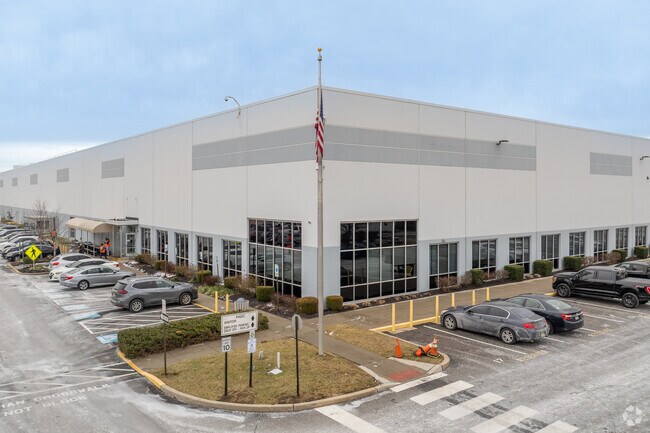


Property Detail
300 Crossing Dr
05-018-067
24.1823AC LOT #2 SEC III KEYSTONE INDUSTRIAL PARK 177 ON NEWPORTVILLE RD
Warehouse
Bucks
PI
Pennsylvania
C and X Area of minimal flood hazard, usually depicted on FIRMs as above the 500-year flood level.
2
2025
24.18 AC
2026
Bucks
100304
Philadelphia
242,550 SF
Philadelphia-Camden-Wilmington, PA-NJ-DE-MD
NEARBY LISTINGS FOR SALE OR LEASE
DEMOGRAPHICS near 300 Crossing Dr
1 mile
3 mile
5 mile
2025 Total Population
11,364
88,560
247,273
2030 Population
11,370
88,714
248,716
Pop Growth 2025-2030
+ 0.05%
+ 0.17%
+ 0.58%
Average Age
42
42
42
2025 Total Households
4,507
33,671
93,527
HH Growth 2025-2030
+ 0.02%
+ 0.12%
+ 0.56%
Median Household Inc
$65,014
$80,991
$86,300
Avg Household Size
2.50
2.50
2.60
2025 Avg HH Vehicles
2.00
2.00
2.00
Median Home Value
$327,108
$335,809
$331,854
Median Year Built
1971
1968
1965
Nearby Places
Map Layers
Map Styles
 Street
 Aerial
Layers
 Traffic
 Biking
Places
Listings with unknown addresses are not visible on the map
- Restaurants
- Banks
- Shops
- Fitness
- Groceries
PUBLIC TRANSPORTATION
COMMUTER RAIL
Croydon (R7 - Southeastern Pennsylvania Transportation Authority Regional Rail (SEPTA Regional Rail))
Drive
Walk
Distance
Croydon (R7 - Southeastern Pennsylvania Transportation Authority Regional Rail (SEPTA Regional Rail))
5 min
1.6 mi
Bristol (R7 - Southeastern Pennsylvania Transportation Authority Regional Rail (SEPTA Regional Rail))
Drive
Walk
Distance
Bristol (R7 - Southeastern Pennsylvania Transportation Authority Regional Rail (SEPTA Regional Rail))
11 min
4.1 mi
AIRPORT
Trenton Mercer
Drive
Walk
Distance
Trenton Mercer
26 min
15.1 mi
Philadelphia International
Drive
Walk
Distance
Philadelphia International
48 min
29.6 mi
Freight Ports
Port of Philadelphia
Drive
Walk
Distance
Port of Philadelphia
28 min
15.9 mi
Nearby Properties
Address
Land Use
TOTAL SIZE
Lot Size
Zoning
Address
Land Use
TOTAL SIZE
Lot Size
Zoning
8.60 AC
R-1
Address
Land Use
TOTAL SIZE
Lot Size
Zoning
Address
Land Use
TOTAL SIZE
Lot Size
Zoning
32,912 SF
42.06 AC
AO
Address
Land Use
TOTAL SIZE
Lot Size
Zoning
11,280 SF
26.16 AC
R3
Address
Land Use
TOTAL SIZE
Lot Size
Zoning
Address
Land Use
TOTAL SIZE
Lot Size
Zoning
66.09 AC
I-2
Address
Land Use
TOTAL SIZE
Lot Size
Zoning
34,920 SF
38 AC
CD
Address
Land Use
TOTAL SIZE
Lot Size
Zoning
8.19 AC
I-P
Address
Land Use
TOTAL SIZE
Lot Size
Zoning
150,000 SF
21.46 AC
R3
Address
Land Use
TOTAL SIZE
Lot Size
Zoning
10,025 SF
19.11 AC
CD
Address
Land Use
TOTAL SIZE
Lot Size
Zoning
19.95 AC
CD
Address
Land Use
TOTAL SIZE
Lot Size
Zoning
242,550 SF
24.32 AC
PI
Address
Land Use
TOTAL SIZE
Lot Size
Zoning
72,540 SF
14.02 AC
CD
Address
Land Use
TOTAL SIZE
Lot Size
Zoning
10,779 SF
19.07 AC
CD
Address
Land Use
TOTAL SIZE
Lot Size
Zoning
125,307 SF
31.79 AC
VC
Address
Land Use
TOTAL SIZE
Lot Size
Zoning
179,920 SF
23.92 AC
CS
Address
Land Use
TOTAL SIZE
Lot Size
Zoning
171,918 SF
17.70 AC
AO
Address
Land Use
TOTAL SIZE
Lot Size
Zoning
555,218 SF
24.94 AC
M2
Address
Land Use
TOTAL SIZE
Lot Size
Zoning
281,600 SF
26.57 AC
PI
Address
Land Use
TOTAL SIZE
Lot Size
Zoning
244,000 SF
22.72 AC
M2
Address
Land Use
TOTAL SIZE
Lot Size
Zoning
465,507 SF
24.01 AC
M2
Address
Land Use
TOTAL SIZE
Lot Size
Zoning
34,184 SF
14.54 AC
CD
Address
Land Use
TOTAL SIZE
Lot Size
Zoning
9.54 AC
M2
Address
Land Use
TOTAL SIZE
Lot Size
Zoning
19.78 AC
CD
Address
Land Use
TOTAL SIZE
Lot Size
Zoning
146,556 SF
30.35 AC
C
Address
Land Use
TOTAL SIZE
Lot Size
Zoning
435,527 SF
16.20 AC
M2
Address
Land Use
TOTAL SIZE
Lot Size
Zoning
4,722 SF
14.30 AC
CD
Address
Land Use
TOTAL SIZE
Lot Size
Zoning
8,878 SF
15.04 AC
R2
Address
Land Use
TOTAL SIZE
Lot Size
Zoning
93,562 SF
12.60 AC
AO
The World's #1 Commercial Real Estate Marketplace
Connect with us
© 2026 CoStar Group
The information above has been obtained from sources believed reliable. While we do not doubt its accuracy we have not verified it and make no guarantee, warranty or representation about it. It is your responsibility to independently confirm its accuracy and completeness. Any projections, opinions, assumptions, or estimates used are for example only and do not represent the current or future performance of the property. The value of this transaction to you depends on tax and other factors which should be evaluated by your tax, financial, and legal advisors. You and your advisors should conduct a careful, independent investigation of the property to determine to your satisfaction the suitability of the property for your needs.