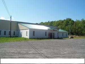
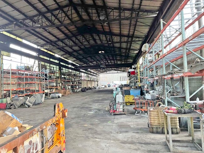
Property Record
300 Delaware St, Archbald, PA 18403
NEARBY LISTINGS FOR SALE OR LEASE
Property Detail
300 Delaware St
Scranton--Wilkes-Barre--Hazelton, PA
8A W-01 B-995 L-233B
10501010001
Lackawanna
Industrialgeneral
Pennsylvania
X
233b
42069C0231D
3.96 AC
2025
I-81 Corridor
2025
Philadelphia
111100
DEMOGRAPHICS near 300 Delaware St
1 Mile
3 Mile
5 Mile
2024 Total Population
4,383
18,707
38,215
2029 Population
4,334
18,376
37,781
Pop Growth 2024-2029
(1.12%)
(1.77%)
(1.14%)
Average Age
43
43
43
2024 Total Households
1,793
8,037
16,627
HH Growth 2024-2029
(1.12%)
(1.79%)
(1.14%)
Median Household Inc
$65,266
$60,979
$63,535
Avg Household Size
2.40
2.30
2.30
2024 Avg HH Vehicles
2.00
2.00
2.00
Median Home Value
$176,948
$167,593
$169,193
Median Year Built
1949
1949
1954
Nearby Places
Map Layers
Map Styles
 Street
 Aerial
- Restaurants
- Banks
- Shops
- Fitness
- Groceries
PUBLIC TRANSPORTATION
AIRPORT
Wilkes-Barre/Scranton International
DRIVE
WALK
Distance
Wilkes-Barre/Scranton International
30 min
20.3 mi
Freight Ports
Maher Terminal
DRIVE
WALK
Distance
Maher Terminal
152 min
120.8 mi
SALE & LEASE HISTORY
LISTING DATE
SALE/LEASE

Jul 27, 2022
For Lease
Jul 21, 2022
For Sale
Nearby Properties
Address
Land Use
TOTAL SIZE
Lot Size
Zoning
Address
Land Use
TOTAL SIZE
Lot Size
Zoning
65.35 AC
Address
Land Use
TOTAL SIZE
Lot Size
Zoning
112.27 AC
Address
Land Use
TOTAL SIZE
Lot Size
Zoning
92.02 AC
Address
Land Use
TOTAL SIZE
Lot Size
Zoning
70.21 AC
Address
Land Use
TOTAL SIZE
Lot Size
Zoning
26.40 AC
Address
Land Use
TOTAL SIZE
Lot Size
Zoning
59.07 AC
Address
Land Use
TOTAL SIZE
Lot Size
Zoning
43.89 AC
Address
Land Use
TOTAL SIZE
Lot Size
Zoning
6.89 AC
Address
Land Use
TOTAL SIZE
Lot Size
Zoning
135.22 AC
Address
Land Use
TOTAL SIZE
Lot Size
Zoning
14.57 AC
Address
Land Use
TOTAL SIZE
Lot Size
Zoning
38.12 AC
Address
Land Use
TOTAL SIZE
Lot Size
Zoning
29.58 AC
Address
Land Use
TOTAL SIZE
Lot Size
Zoning
99.18 AC
Address
Land Use
TOTAL SIZE
Lot Size
Zoning
10.10 AC
Address
Land Use
TOTAL SIZE
Lot Size
Zoning
30.06 AC
Address
Land Use
TOTAL SIZE
Lot Size
Zoning
197.82 AC
Address
Land Use
TOTAL SIZE
Lot Size
Zoning
7.30 AC
Address
Land Use
TOTAL SIZE
Lot Size
Zoning
44.05 AC
Address
Land Use
TOTAL SIZE
Lot Size
Zoning
27.39 AC
Address
Land Use
TOTAL SIZE
Lot Size
Zoning
4.96 AC
Address
Land Use
TOTAL SIZE
Lot Size
Zoning
18.30 AC
Address
Land Use
TOTAL SIZE
Lot Size
Zoning
10.59 AC
Address
Land Use
TOTAL SIZE
Lot Size
Zoning
5.35 AC
Address
Land Use
TOTAL SIZE
Lot Size
Zoning
10.34 AC
Address
Land Use
TOTAL SIZE
Lot Size
Zoning
14.41 AC
Address
Land Use
TOTAL SIZE
Lot Size
Zoning
10.38 AC
Address
Land Use
TOTAL SIZE
Lot Size
Zoning
18.61 AC
Address
Land Use
TOTAL SIZE
Lot Size
Zoning
1.80 AC
Address
Land Use
TOTAL SIZE
Lot Size
Zoning
2,428 SF
357.58 AC
Address
Land Use
TOTAL SIZE
Lot Size
Zoning
13.64 AC
The World's #1 Commercial Real Estate Marketplace
Connect with us
© 2025 CoStar Group
The information above has been obtained from sources believed reliable. While we do not doubt its accuracy we have not verified it and make no guarantee, warranty or representation about it. It is your responsibility to independently confirm its accuracy and completeness. Any projections, opinions, assumptions, or estimates used are for example only and do not represent the current or future performance of the property. The value of this transaction to you depends on tax and other factors which should be evaluated by your tax, financial, and legal advisors. You and your advisors should conduct a careful, independent investigation of the property to determine to your satisfaction the suitability of the property for your needs.