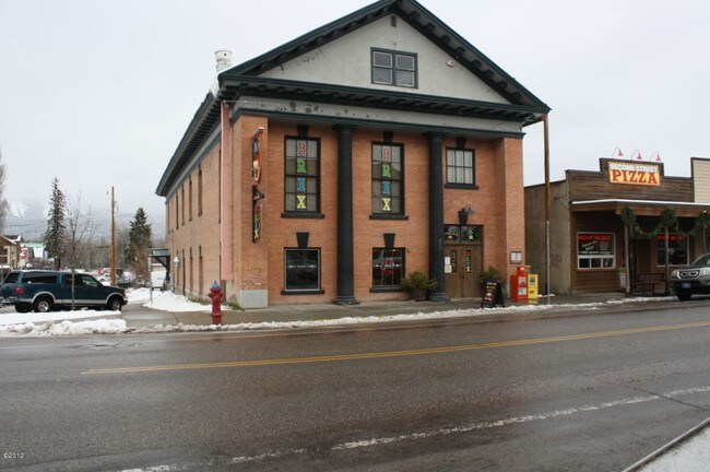
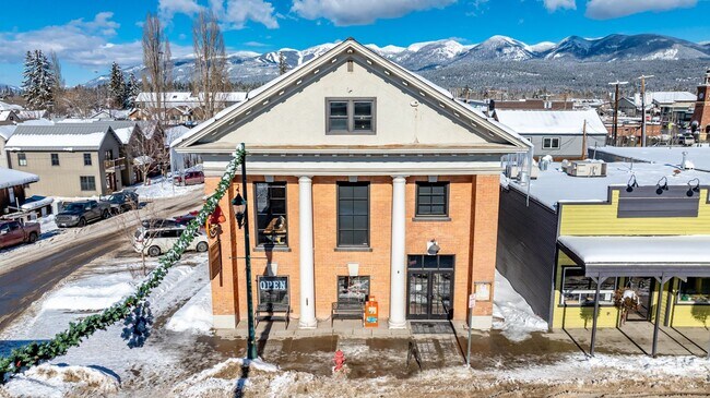
Property Record
300 E 2Nd St E, Whitefish, MT 59937


Property Detail
300 E 2Nd St E
07-4292-36-1-19-13-7002
BRIX CONDO ON L17-18 BLK 37 WFSH, S36, T31 N, R22 W, UNIT 2, 52.07% COMMON AREA INTEREST
Officecondo
Flathead
B and X Area of moderate flood hazard, usually the area between the limits of the 100-year and 500-year floods.
Montana
2025
0.03 AC
2025
Glacier Country
000402
Other Market Areas
3,786 SF
Kalispell, MT
NEARBY LISTINGS FOR SALE OR LEASE
DEMOGRAPHICS near 300 E 2Nd St E
1 mile
3 mile
5 mile
2024 Total Population
6,757
14,133
18,030
2029 Population
7,395
15,572
19,851
Pop Growth 2024-2029
+ 9.44%
+ 10.18%
+ 10.10%
Average Age
43
44
44
2024 Total Households
3,130
6,348
7,968
HH Growth 2024-2029
+ 9.46%
+ 10.18%
+ 10.13%
Median Household Inc
$73,695
$77,263
$81,407
Avg Household Size
2.10
2.20
2.20
2024 Avg HH Vehicles
2.00
2.00
2.00
Median Home Value
$776,122
$781,319
$773,704
Median Year Built
1989
1995
1994
Nearby Places
Map Layers
Map Styles
 Street
 Aerial
Transit
 Traffic
 Biking
Places
Listings with unknown addresses are not visible on the map
- Restaurants
- Banks
- Shops
- Fitness
- Groceries
PUBLIC TRANSPORTATION
COMMUTER RAIL
Drive
Walk
Distance
1 min
7 min
0.4 mi
AIRPORT
Glacier Park International
Drive
Walk
Distance
Glacier Park International
17 min
11.8 mi
SALE & LEASE HISTORY
LISTING DATE
SALE/LEASE

May 28, 2025
For Sale
Apr 21, 2021
For Sale
Nearby Properties
Address
Land Use
TOTAL SIZE
Lot Size
Zoning
Address
Land Use
TOTAL SIZE
Lot Size
Zoning
82,400 SF
25.75 AC
Address
Land Use
TOTAL SIZE
Lot Size
Zoning
118,500 SF
11.43 AC
Address
Land Use
TOTAL SIZE
Lot Size
Zoning
9.74 AC
Address
Land Use
TOTAL SIZE
Lot Size
Zoning
46,679 SF
0.69 AC
6
Address
Land Use
TOTAL SIZE
Lot Size
Zoning
100,320 SF
7.10 AC
1
Address
Land Use
TOTAL SIZE
Lot Size
Zoning
54,682 SF
5.80 AC
Address
Land Use
TOTAL SIZE
Lot Size
Zoning
135,347 SF
7.95 AC
Address
Land Use
TOTAL SIZE
Lot Size
Zoning
13,770 SF
60 AC
Address
Land Use
TOTAL SIZE
Lot Size
Zoning
50,306 SF
2.66 AC
Address
Land Use
TOTAL SIZE
Lot Size
Zoning
0.22 AC
Address
Land Use
TOTAL SIZE
Lot Size
Zoning
58,425 SF
2.96 AC
Address
Land Use
TOTAL SIZE
Lot Size
Zoning
52,259 SF
3.94 AC
Address
Land Use
TOTAL SIZE
Lot Size
Zoning
36,114 SF
2.36 AC
Address
Land Use
TOTAL SIZE
Lot Size
Zoning
0.38 AC
Address
Land Use
TOTAL SIZE
Lot Size
Zoning
52,630 SF
2.33 AC
Address
Land Use
TOTAL SIZE
Lot Size
Zoning
58,385 SF
4.20 AC
Address
Land Use
TOTAL SIZE
Lot Size
Zoning
10,681 SF
95.19 AC
Address
Land Use
TOTAL SIZE
Lot Size
Zoning
30,684 SF
8.34 AC
Address
Land Use
TOTAL SIZE
Lot Size
Zoning
0.22 AC
Address
Land Use
TOTAL SIZE
Lot Size
Zoning
0.15 AC
Address
Land Use
TOTAL SIZE
Lot Size
Zoning
57,230 SF
4.98 AC
Address
Land Use
TOTAL SIZE
Lot Size
Zoning
14,045 SF
5.42 AC
Address
Land Use
TOTAL SIZE
Lot Size
Zoning
25,400 SF
10.59 AC
Address
Land Use
TOTAL SIZE
Lot Size
Zoning
7,886 SF
0.15 AC
Address
Land Use
TOTAL SIZE
Lot Size
Zoning
13,872 SF
0.86 AC
6
Address
Land Use
TOTAL SIZE
Lot Size
Zoning
1,785 SF
103.25 AC
Address
Land Use
TOTAL SIZE
Lot Size
Zoning
17,538 SF
1.51 AC
1
Address
Land Use
TOTAL SIZE
Lot Size
Zoning
10,484 SF
1.50 AC
Address
Land Use
TOTAL SIZE
Lot Size
Zoning
41,249 SF
1.59 AC
Address
Land Use
TOTAL SIZE
Lot Size
Zoning
10,252 SF
0.85 AC
1
The World's #1 Commercial Real Estate Marketplace
Connect with us
© 2026 CoStar Group
The information above has been obtained from sources believed reliable. While we do not doubt its accuracy we have not verified it and make no guarantee, warranty or representation about it. It is your responsibility to independently confirm its accuracy and completeness. Any projections, opinions, assumptions, or estimates used are for example only and do not represent the current or future performance of the property. The value of this transaction to you depends on tax and other factors which should be evaluated by your tax, financial, and legal advisors. You and your advisors should conduct a careful, independent investigation of the property to determine to your satisfaction the suitability of the property for your needs.