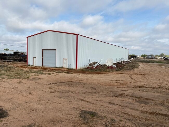
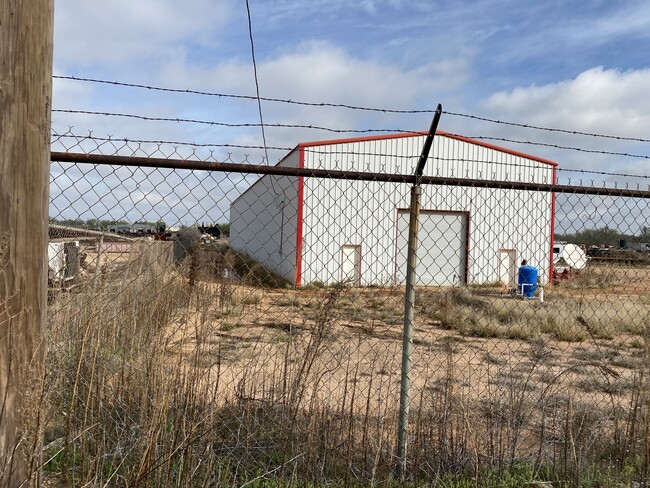
Property Record
300 E 57Th St, Odessa, TX 79762

Current Lease Availabilities
Property Detail
300 E 57Th St
00600-00830-00000
ANDREWS TRACT 43 (CARD #51A)
Commercialnec
Ector
EC5
Texas
AE The base floodplain where base flood elevations are provided. AE Zones are now used on new format FIRMs instead of A1-A30 Zones.
2.12 AC
2025
Midland & Odessa
2025
Other Market Areas
000500
Odessa, TX
600 SF
NEARBY LISTINGS FOR SALE OR LEASE
DEMOGRAPHICS near 300 E 57Th St
1 mile
3 mile
5 mile
2025 Total Population
6,773
60,071
118,890
2030 Population
7,207
63,917
126,863
Pop Growth 2025-2030
+ 6.41%
+ 6.40%
+ 6.71%
Average Age
36
35
35
2025 Total Households
2,562
21,886
42,849
HH Growth 2025-2030
+ 7.57%
+ 7.60%
+ 7.88%
Median Household Inc
$65,332
$66,934
$66,048
Avg Household Size
2.60
2.60
2.70
2025 Avg HH Vehicles
2.00
2.00
2.00
Median Home Value
$167,567
$186,985
$194,488
Median Year Built
1975
1973
1976
Nearby Places
Map Layers
Map Styles
 Street
 Aerial
Transit
 Traffic
 Biking
Places
Listings with unknown addresses are not visible on the map
- Restaurants
- Banks
- Shops
- Fitness
- Groceries
PUBLIC TRANSPORTATION
AIRPORT
Midland International Air And Space Port
Drive
Walk
Distance
Midland International Air And Space Port
23 min
15.2 mi
Nearby Properties
Address
Land Use
TOTAL SIZE
Lot Size
Zoning
Address
Land Use
TOTAL SIZE
Lot Size
Zoning
Address
Land Use
TOTAL SIZE
Lot Size
Zoning
Address
Land Use
TOTAL SIZE
Lot Size
Zoning
22,304 SF
67.42 AC
EB4
Address
Land Use
TOTAL SIZE
Lot Size
Zoning
54,990 SF
46.21 AC
ED5
Address
Land Use
TOTAL SIZE
Lot Size
Zoning
Address
Land Use
TOTAL SIZE
Lot Size
Zoning
295,840 SF
12.04 AC
EC1
Address
Land Use
TOTAL SIZE
Lot Size
Zoning
Address
Land Use
TOTAL SIZE
Lot Size
Zoning
Address
Land Use
TOTAL SIZE
Lot Size
Zoning
87,558 SF
62.63 AC
ED3
Address
Land Use
TOTAL SIZE
Lot Size
Zoning
2,268 SF
15.91 AC
EB2
Address
Land Use
TOTAL SIZE
Lot Size
Zoning
Address
Land Use
TOTAL SIZE
Lot Size
Zoning
136,794 SF
631.22 AC
EC3
Address
Land Use
TOTAL SIZE
Lot Size
Zoning
124,185 SF
9.10 AC
ED3
Address
Land Use
TOTAL SIZE
Lot Size
Zoning
192,022 SF
8.83 AC
ED3
Address
Land Use
TOTAL SIZE
Lot Size
Zoning
80,722 SF
20.09 AC
ED3
Address
Land Use
TOTAL SIZE
Lot Size
Zoning
197,580 SF
8.77 AC
ED3
Address
Land Use
TOTAL SIZE
Lot Size
Zoning
Address
Land Use
TOTAL SIZE
Lot Size
Zoning
Address
Land Use
TOTAL SIZE
Lot Size
Zoning
155,744 SF
49.20 AC
EA7
Address
Land Use
TOTAL SIZE
Lot Size
Zoning
106,812 SF
28 AC
EC2
Address
Land Use
TOTAL SIZE
Lot Size
Zoning
7,236 SF
10.80 AC
ED3
Address
Land Use
TOTAL SIZE
Lot Size
Zoning
348,480 SF
82.30 AC
EC4
Address
Land Use
TOTAL SIZE
Lot Size
Zoning
169,332 SF
7.26 AC
ED3
Address
Land Use
TOTAL SIZE
Lot Size
Zoning
2,978 SF
56 AC
ED2
Address
Land Use
TOTAL SIZE
Lot Size
Zoning
133,454 SF
25.41 AC
EE2
Address
Land Use
TOTAL SIZE
Lot Size
Zoning
2,525 SF
7.20 AC
ED3
Address
Land Use
TOTAL SIZE
Lot Size
Zoning
135,155 SF
9.97 AC
ED4
Address
Land Use
TOTAL SIZE
Lot Size
Zoning
Address
Land Use
TOTAL SIZE
Lot Size
Zoning
146,559 SF
15.96 AC
ED4
Address
Land Use
TOTAL SIZE
Lot Size
Zoning
4,420 SF
6.28 AC
ED6
The World's #1 Commercial Real Estate Marketplace
Connect with us
© 2026 CoStar Group
The information above has been obtained from sources believed reliable. While we do not doubt its accuracy we have not verified it and make no guarantee, warranty or representation about it. It is your responsibility to independently confirm its accuracy and completeness. Any projections, opinions, assumptions, or estimates used are for example only and do not represent the current or future performance of the property. The value of this transaction to you depends on tax and other factors which should be evaluated by your tax, financial, and legal advisors. You and your advisors should conduct a careful, independent investigation of the property to determine to your satisfaction the suitability of the property for your needs.