Property Record
300 E Brazos St, Freeport, TX 77541


Property Detail
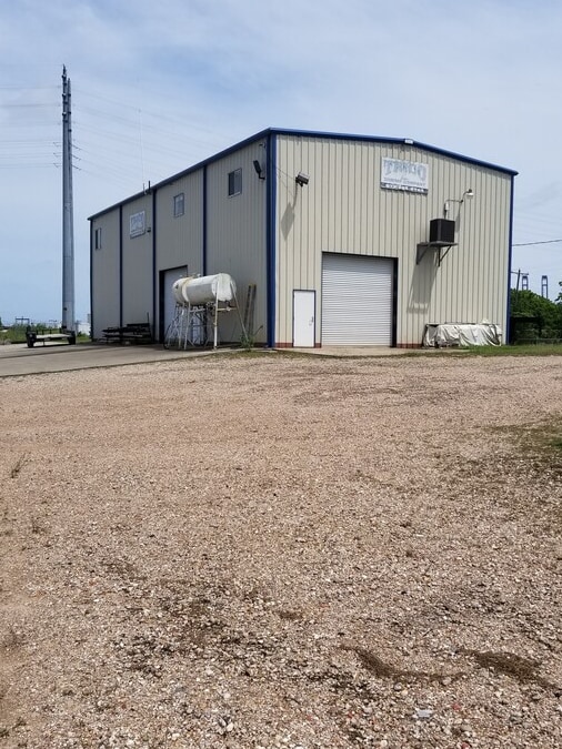
300 E Brazos St
0028-0007-100
A0028 S F AUSTIN TRACT B1A1-B1B1 (FREEPORT) ACRES .5365
Commercialnec
BRAZORIA
A Areas with a 1% annual chance of flooding and a 26% chance of flooding over the life of a 30-year mortgage.
Texas
2024
0.54 AC
2025
South Hwy 35
664200
Houston
7,600 SF
Houston-Pasadena-The Woodlands, TX
NEARBY LISTINGS FOR SALE OR LEASE
DEMOGRAPHICS near 300 E Brazos St
1 mile
3 mile
5 mile
2025 Total Population
1,538
13,906
17,924
2030 Population
1,743
15,674
20,364
Pop Growth 2025-2030
+ 13.33%
+ 12.71%
+ 13.61%
Average Age
36
37
39
2025 Total Households
504
4,875
6,637
HH Growth 2025-2030
+ 13.69%
+ 13.29%
+ 14.37%
Median Household Inc
$8,092
$50,361
$53,903
Avg Household Size
3.00
2.80
2.70
2025 Avg HH Vehicles
2.00
2.00
2.00
Median Home Value
$240,456
$167,950
$196,441
Median Year Built
1972
1976
1978
Nearby Places
Map Layers
Map Styles
 Street
 Aerial
Transit
 Traffic
 Biking
Places
Listings with unknown addresses are not visible on the map
- Restaurants
- Banks
- Shops
- Fitness
- Groceries
SALE & LEASE HISTORY
LISTING DATE
SALE/LEASE

Jun 21, 2023
For Sale
Jul 23, 2020
For Lease
Apr 30, 2020
For Sale
Apr 29, 2020
For Sale
Apr 29, 2020
For Sale
Nearby Properties
Address
Land Use
TOTAL SIZE
Lot Size
Zoning
Address
Land Use
TOTAL SIZE
Lot Size
Zoning
Address
Land Use
TOTAL SIZE
Lot Size
Zoning
Address
Land Use
TOTAL SIZE
Lot Size
Zoning
Address
Land Use
TOTAL SIZE
Lot Size
Zoning
Address
Land Use
TOTAL SIZE
Lot Size
Zoning
Address
Land Use
TOTAL SIZE
Lot Size
Zoning
Address
Land Use
TOTAL SIZE
Lot Size
Zoning
320,260 SF
31.88 AC
Address
Land Use
TOTAL SIZE
Lot Size
Zoning
33.09 AC
0050
Address
Land Use
TOTAL SIZE
Lot Size
Zoning
Address
Land Use
TOTAL SIZE
Lot Size
Zoning
61.70 AC
Address
Land Use
TOTAL SIZE
Lot Size
Zoning
Address
Land Use
TOTAL SIZE
Lot Size
Zoning
Address
Land Use
TOTAL SIZE
Lot Size
Zoning
Address
Land Use
TOTAL SIZE
Lot Size
Zoning
Address
Land Use
TOTAL SIZE
Lot Size
Zoning
242.03 AC
0275
Address
Land Use
TOTAL SIZE
Lot Size
Zoning
Address
Land Use
TOTAL SIZE
Lot Size
Zoning
4.27 AC
0170
Address
Land Use
TOTAL SIZE
Lot Size
Zoning
188,497 SF
14.79 AC
1135
Address
Land Use
TOTAL SIZE
Lot Size
Zoning
94,933 SF
18.16 AC
0150
Address
Land Use
TOTAL SIZE
Lot Size
Zoning
122,989 SF
22.98 AC
0211
Address
Land Use
TOTAL SIZE
Lot Size
Zoning
128,282 SF
4.39 AC
0001
Address
Land Use
TOTAL SIZE
Lot Size
Zoning
24.81 AC
0031
Address
Land Use
TOTAL SIZE
Lot Size
Zoning
48,773 SF
Address
Land Use
TOTAL SIZE
Lot Size
Zoning
1.75 AC
Address
Land Use
TOTAL SIZE
Lot Size
Zoning
124,367 SF
6.17 AC
Address
Land Use
TOTAL SIZE
Lot Size
Zoning
15.78 AC
0130
Address
Land Use
TOTAL SIZE
Lot Size
Zoning
67,270 SF
6.12 AC
Address
Land Use
TOTAL SIZE
Lot Size
Zoning
Address
Land Use
TOTAL SIZE
Lot Size
Zoning
129,934 SF
10.96 AC
0006
Address
Land Use
TOTAL SIZE
Lot Size
Zoning
83,532 SF
3.71 AC
The World's #1 Commercial Real Estate Marketplace
Connect with us
© 2026 CoStar Group
The information above has been obtained from sources believed reliable. While we do not doubt its accuracy we have not verified it and make no guarantee, warranty or representation about it. It is your responsibility to independently confirm its accuracy and completeness. Any projections, opinions, assumptions, or estimates used are for example only and do not represent the current or future performance of the property. The value of this transaction to you depends on tax and other factors which should be evaluated by your tax, financial, and legal advisors. You and your advisors should conduct a careful, independent investigation of the property to determine to your satisfaction the suitability of the property for your needs.