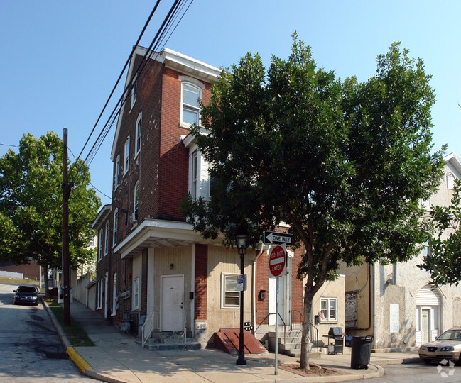
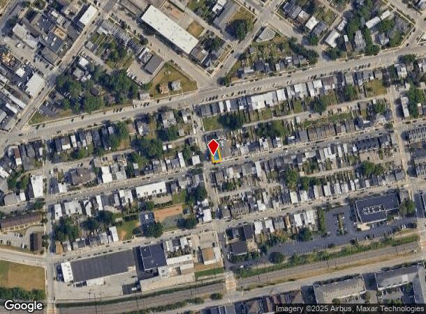
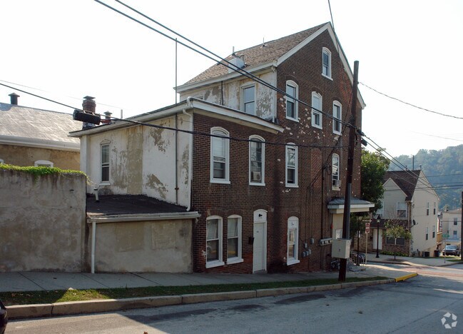
Property Record
300 E Hector St, Conshohocken, PA 19428
NEARBY LISTINGS FOR SALE OR LEASE
Property Detail
300 E Hector St
05-00-05272-006
ASSESSOR BLOCK-UNIT NUMBER 22-72
Apartment
Montgomery
X
Pennsylvania
42091C0358G
72
2024
0.06 AC
2025
Conshohocken/Plymouth Meeting
204104
Philadelphia
5,073 SF
Philadelphia-Camden-Wilmington, PA-NJ-DE-MD
DEMOGRAPHICS near 300 E Hector St
1 Mile
3 Mile
5 Mile
2024 Total Population
14,172
56,700
221,372
2029 Population
14,403
57,850
224,359
Pop Growth 2024-2029
+ 1.63%
+ 2.03%
+ 1.35%
Average Age
37
40
40
2024 Total Households
6,926
23,539
85,851
HH Growth 2024-2029
+ 1.76%
+ 2.07%
+ 1.37%
Median Household Inc
$115,874
$124,160
$102,891
Avg Household Size
2.00
2.30
2.40
2024 Avg HH Vehicles
2.00
2.00
2.00
Median Home Value
$411,809
$470,423
$420,781
Median Year Built
1961
1968
1963
Nearby Places
Map Layers
Map Styles
 Street
 Aerial
- Restaurants
- Banks
- Shops
- Fitness
- Groceries
PUBLIC TRANSPORTATION
TRANSIT/SUBWAY
Conshohocken (R6 - Southeastern Pennsylvania Transportation Authority Regional Rail (SEPTA Regional Rail))
DRIVE
WALK
Distance
Conshohocken (R6 - Southeastern Pennsylvania Transportation Authority Regional Rail (SEPTA Regional Rail))
2 min
10 min
0.4 mi
Spring Mill (R6 - Southeastern Pennsylvania Transportation Authority Regional Rail (SEPTA Regional Rail))
DRIVE
WALK
Distance
Spring Mill (R6 - Southeastern Pennsylvania Transportation Authority Regional Rail (SEPTA Regional Rail))
3 min
18 min
0.9 mi
COMMUTER RAIL
Conshohocken (R6 - Southeastern Pennsylvania Transportation Authority Regional Rail (SEPTA Regional Rail))
DRIVE
WALK
Distance
Conshohocken (R6 - Southeastern Pennsylvania Transportation Authority Regional Rail (SEPTA Regional Rail))
2 min
8 min
0.4 mi
DRIVE
WALK
Distance
2 min
10 min
0.5 mi
AIRPORT
Philadelphia International
DRIVE
WALK
Distance
Philadelphia International
38 min
23.7 mi
Trenton Mercer
DRIVE
WALK
Distance
Trenton Mercer
54 min
39.6 mi
Freight Ports
South Jersey Port
DRIVE
WALK
Distance
South Jersey Port
29 min
18.2 mi
Nearby Properties
Address
Land Use
TOTAL SIZE
Lot Size
Zoning
Address
Land Use
TOTAL SIZE
Lot Size
Zoning
350,807 SF
50 AC
R1
Address
Land Use
TOTAL SIZE
Lot Size
Zoning
520,066 SF
1.02 AC
HB
Address
Land Use
TOTAL SIZE
Lot Size
Zoning
702,393 SF
61.81 AC
RA
Address
Land Use
TOTAL SIZE
Lot Size
Zoning
723,623 SF
6.69 AC
HVY
Address
Land Use
TOTAL SIZE
Lot Size
Zoning
510,312 SF
51.75 AC
IA
Address
Land Use
TOTAL SIZE
Lot Size
Zoning
469,066 SF
47 AC
MU
Address
Land Use
TOTAL SIZE
Lot Size
Zoning
527,618 SF
7.89 AC
SP2
Address
Land Use
TOTAL SIZE
Lot Size
Zoning
622,736 SF
2.06 AC
O
Address
Land Use
TOTAL SIZE
Lot Size
Zoning
676,867 SF
2.98 AC
SP2
Address
Land Use
TOTAL SIZE
Lot Size
Zoning
519,822 SF
19.53 AC
AR
Address
Land Use
TOTAL SIZE
Lot Size
Zoning
470,032 SF
2.98 AC
SP2
Address
Land Use
TOTAL SIZE
Lot Size
Zoning
434,229 SF
3.24 AC
HI
Address
Land Use
TOTAL SIZE
Lot Size
Zoning
561,359 SF
48.06 AC
R1
Address
Land Use
TOTAL SIZE
Lot Size
Zoning
426,711 SF
6.04 AC
HI
Address
Land Use
TOTAL SIZE
Lot Size
Zoning
843,567 SF
50.79 AC
HI
Address
Land Use
TOTAL SIZE
Lot Size
Zoning
214,714 SF
22.23 AC
R1
Address
Land Use
TOTAL SIZE
Lot Size
Zoning
531,656 SF
19.51 AC
HVY
Address
Land Use
TOTAL SIZE
Lot Size
Zoning
660,582 SF
5.43 AC
O
Address
Land Use
TOTAL SIZE
Lot Size
Zoning
370,404 SF
15.55 AC
SM1
Address
Land Use
TOTAL SIZE
Lot Size
Zoning
961,106 SF
5.47 AC
LI
Address
Land Use
TOTAL SIZE
Lot Size
Zoning
452,740 SF
11.03 AC
C
Address
Land Use
TOTAL SIZE
Lot Size
Zoning
610,819 SF
3.17 AC
O1
Address
Land Use
TOTAL SIZE
Lot Size
Zoning
310,900 SF
55.48 AC
HI
Address
Land Use
TOTAL SIZE
Lot Size
Zoning
10.44 AC
HI
Address
Land Use
TOTAL SIZE
Lot Size
Zoning
320,804 SF
30.85 AC
CR
Address
Land Use
TOTAL SIZE
Lot Size
Zoning
368,147 SF
3.70 AC
O1
Address
Land Use
TOTAL SIZE
Lot Size
Zoning
312,710 SF
30.07 AC
APTLR
Address
Land Use
TOTAL SIZE
Lot Size
Zoning
346,163 SF
16.53 AC
SC
Address
Land Use
TOTAL SIZE
Lot Size
Zoning
197,630 SF
1.73 AC
SP2
Address
Land Use
TOTAL SIZE
Lot Size
Zoning
333,974 SF
18.56 AC
HR
The World's #1 Commercial Real Estate Marketplace
Connect with us
© 2025 CoStar Group
The information above has been obtained from sources believed reliable. While we do not doubt its accuracy we have not verified it and make no guarantee, warranty or representation about it. It is your responsibility to independently confirm its accuracy and completeness. Any projections, opinions, assumptions, or estimates used are for example only and do not represent the current or future performance of the property. The value of this transaction to you depends on tax and other factors which should be evaluated by your tax, financial, and legal advisors. You and your advisors should conduct a careful, independent investigation of the property to determine to your satisfaction the suitability of the property for your needs.