Property Record
300 Henry Ct, Flushing, MI 48433
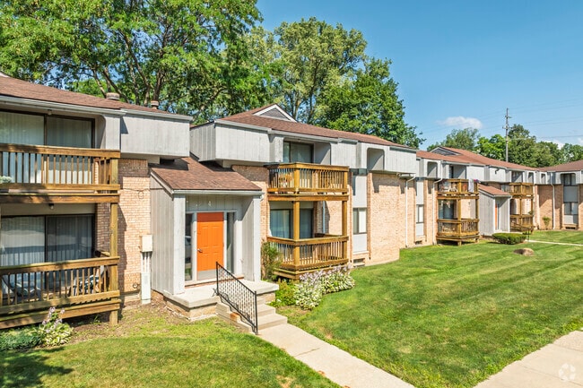


Property Detail
300 Henry Ct
55-27-400-001
PART OF GOVT LOT 7 BEG AT NW COR OF LOT 5 BLK 26 THE ENLARGED PLAT OF FLUSHING TH S 0* 13 MIN 40 SEC E 358.87 FT TH N 89* 11
Commercialnec
Genesee
R3-B (HDR)
Michigan
AE The base floodplain where base flood elevations are provided. AE Zones are now used on new format FIRMs instead of A1-A30 Zones.
5,7-9
2024
11.44 AC
2025
Flushing
010603
Detroit
106,551 SF
Flint, MI
NEARBY LISTINGS FOR SALE OR LEASE
-
-
View all Flushing listings for sale on LoopNet.com
DEMOGRAPHICS near 300 Henry Ct
1 mile
3 mile
5 mile
2025 Total Population
4,599
15,935
31,198
2030 Population
4,447
15,457
30,415
Pop Growth 2025-2030
(3.31%)
(3.00%)
(2.51%)
Average Age
43
44
44
2025 Total Households
1,974
6,479
12,548
HH Growth 2025-2030
(3.24%)
(3.03%)
(2.51%)
Median Household Inc
$80,895
$86,512
$79,208
Avg Household Size
2.30
2.40
2.40
2025 Avg HH Vehicles
2.00
2.00
2.00
Median Home Value
$201,426
$224,928
$215,579
Median Year Built
1969
1971
1973
Nearby Places
Map Layers
Map Styles
 Street
 Aerial
Layers
 Traffic
 Biking
Places
Listings with unknown addresses are not visible on the map
- Restaurants
- Banks
- Shops
- Fitness
- Groceries
PUBLIC TRANSPORTATION
AIRPORT
Bishop International
Drive
Walk
Distance
Bishop International
31 min
13.5 mi
Freight Ports
Port of Toledo
Drive
Walk
Distance
Port of Toledo
148 min
121.6 mi
Nearby Properties
Address
Land Use
TOTAL SIZE
Lot Size
Zoning
Address
Land Use
TOTAL SIZE
Lot Size
Zoning
72,367 SF
10.60 AC
R3-B (HDR)
Address
Land Use
TOTAL SIZE
Lot Size
Zoning
67,266 SF
8.11 AC
CBD CENTL
Address
Land Use
TOTAL SIZE
Lot Size
Zoning
133,008 SF
7.46 AC
RES R-3 A
Address
Land Use
TOTAL SIZE
Lot Size
Zoning
62,121 SF
6.23 AC
B-2 CC GEN
Address
Land Use
TOTAL SIZE
Lot Size
Zoning
21,763 SF
4.36 AC
B-2 CC GEN
Address
Land Use
TOTAL SIZE
Lot Size
Zoning
31,008 SF
6.14 AC
R3-B (HDR)
Address
Land Use
TOTAL SIZE
Lot Size
Zoning
2.74 AC
Address
Land Use
TOTAL SIZE
Lot Size
Zoning
12,500 SF
6.84 AC
Address
Land Use
TOTAL SIZE
Lot Size
Zoning
34,708 SF
5.05 AC
B-2 CC GEN
Address
Land Use
TOTAL SIZE
Lot Size
Zoning
1,440 SF
104 AC
RES R-1 (L
Address
Land Use
TOTAL SIZE
Lot Size
Zoning
3.24 AC
Address
Land Use
TOTAL SIZE
Lot Size
Zoning
18.06 AC
Address
Land Use
TOTAL SIZE
Lot Size
Zoning
2.40 AC
Address
Land Use
TOTAL SIZE
Lot Size
Zoning
1.26 AC
Address
Land Use
TOTAL SIZE
Lot Size
Zoning
15,160 SF
1.49 AC
B-2 CC GEN
Address
Land Use
TOTAL SIZE
Lot Size
Zoning
1.28 AC
Address
Land Use
TOTAL SIZE
Lot Size
Zoning
1.62 AC
Address
Land Use
TOTAL SIZE
Lot Size
Zoning
3.93 AC
Address
Land Use
TOTAL SIZE
Lot Size
Zoning
1.61 AC
Address
Land Use
TOTAL SIZE
Lot Size
Zoning
11,088 SF
2 AC
RU-3
Address
Land Use
TOTAL SIZE
Lot Size
Zoning
7,088 SF
6.24 AC
RES R-1 (L
Address
Land Use
TOTAL SIZE
Lot Size
Zoning
Address
Land Use
TOTAL SIZE
Lot Size
Zoning
3,684 SF
70 AC
RSA
Address
Land Use
TOTAL SIZE
Lot Size
Zoning
2,366 SF
128 AC
RSA
Address
Land Use
TOTAL SIZE
Lot Size
Zoning
8,000 SF
1.54 AC
OS-1 (O) O
Address
Land Use
TOTAL SIZE
Lot Size
Zoning
1.38 AC
Address
Land Use
TOTAL SIZE
Lot Size
Zoning
4,480 SF
0.43 AC
Address
Land Use
TOTAL SIZE
Lot Size
Zoning
9,421 SF
1.98 AC
Address
Land Use
TOTAL SIZE
Lot Size
Zoning
16,800 SF
1.15 AC
CBD CENTL
The World's #1 Commercial Real Estate Marketplace
Connect with us
© 2026 CoStar Group
The information above has been obtained from sources believed reliable. While we do not doubt its accuracy we have not verified it and make no guarantee, warranty or representation about it. It is your responsibility to independently confirm its accuracy and completeness. Any projections, opinions, assumptions, or estimates used are for example only and do not represent the current or future performance of the property. The value of this transaction to you depends on tax and other factors which should be evaluated by your tax, financial, and legal advisors. You and your advisors should conduct a careful, independent investigation of the property to determine to your satisfaction the suitability of the property for your needs.