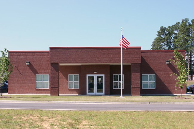
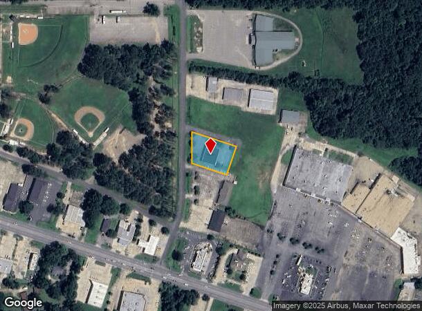
Property Record
300 Holt St, Bastrop, LA 71220
NEARBY LISTINGS FOR SALE OR LEASE
-
-
View all Bastrop listings for sale on LoopNet.com
Property Detail
300 Holt St
920003807
FROM AN IRON PIPE 1785.36 FT SOUTH AND 1215.54 FT WEST OF THE NE CORNER OF SEC 30-21-6; TH RUN S 00 DEG 22 MIN 59 SEC E ALONG
Officebuilding
Morehouse
X
Louisiana
22067C0345C
23
2024
0.64 AC
2024
Other Market Areas
950200
Bastrop, LA
5,462 SF
DEMOGRAPHICS near 300 Holt St
1 Mile
3 Mile
5 Mile
2024 Total Population
3,022
13,824
17,729
2029 Population
2,809
13,048
16,700
Pop Growth 2024-2029
(7.05%)
(5.61%)
(5.80%)
Average Age
42
41
41
2024 Total Households
1,241
5,524
7,095
HH Growth 2024-2029
(6.61%)
(5.16%)
(5.36%)
Median Household Inc
$23,995
$25,985
$31,597
Avg Household Size
2.20
2.30
2.30
2024 Avg HH Vehicles
2.00
2.00
2.00
Median Home Value
$96,060
$93,129
$94,848
Median Year Built
1969
1974
1975
Nearby Places
Map Layers
Map Styles
 Street
 Aerial
- Restaurants
- Banks
- Shops
- Fitness
- Groceries
PUBLIC TRANSPORTATION
AIRPORT
Monroe Regional
DRIVE
WALK
Distance
Monroe Regional
36 min
27.9 mi
Freight Ports
Port of Shreveport
DRIVE
WALK
Distance
Port of Shreveport
161 min
138.3 mi
Nearby Properties
Address
Land Use
TOTAL SIZE
Lot Size
Zoning
Address
Land Use
TOTAL SIZE
Lot Size
Zoning
Address
Land Use
TOTAL SIZE
Lot Size
Zoning
197,062 SF
23.12 AC
Address
Land Use
TOTAL SIZE
Lot Size
Zoning
61,904 SF
4.51 AC
Address
Land Use
TOTAL SIZE
Lot Size
Zoning
0.61 AC
Address
Land Use
TOTAL SIZE
Lot Size
Zoning
61,738 SF
6 AC
Address
Land Use
TOTAL SIZE
Lot Size
Zoning
Address
Land Use
TOTAL SIZE
Lot Size
Zoning
153,814 SF
6.17 AC
Address
Land Use
TOTAL SIZE
Lot Size
Zoning
100,393 SF
21.56 AC
Address
Land Use
TOTAL SIZE
Lot Size
Zoning
Address
Land Use
TOTAL SIZE
Lot Size
Zoning
60,718 SF
2.23 AC
Address
Land Use
TOTAL SIZE
Lot Size
Zoning
0.11 AC
Address
Land Use
TOTAL SIZE
Lot Size
Zoning
Address
Land Use
TOTAL SIZE
Lot Size
Zoning
37,319 SF
3.49 AC
Address
Land Use
TOTAL SIZE
Lot Size
Zoning
128,609 SF
20 AC
Address
Land Use
TOTAL SIZE
Lot Size
Zoning
95,592 SF
19.93 AC
Address
Land Use
TOTAL SIZE
Lot Size
Zoning
50,822 SF
3.45 AC
Address
Land Use
TOTAL SIZE
Lot Size
Zoning
Address
Land Use
TOTAL SIZE
Lot Size
Zoning
Address
Land Use
TOTAL SIZE
Lot Size
Zoning
22,715 SF
Address
Land Use
TOTAL SIZE
Lot Size
Zoning
29.02 AC
Address
Land Use
TOTAL SIZE
Lot Size
Zoning
35,900 SF
12 AC
Address
Land Use
TOTAL SIZE
Lot Size
Zoning
58,378 SF
0.25 AC
Address
Land Use
TOTAL SIZE
Lot Size
Zoning
Address
Land Use
TOTAL SIZE
Lot Size
Zoning
46,606 SF
9 AC
Address
Land Use
TOTAL SIZE
Lot Size
Zoning
57,725 SF
6 AC
Address
Land Use
TOTAL SIZE
Lot Size
Zoning
23,552 SF
4 AC
Address
Land Use
TOTAL SIZE
Lot Size
Zoning
49,414 SF
11 AC
Address
Land Use
TOTAL SIZE
Lot Size
Zoning
18,900 SF
3.70 AC
Address
Land Use
TOTAL SIZE
Lot Size
Zoning
49,419 SF
2.89 AC
Address
Land Use
TOTAL SIZE
Lot Size
Zoning
29,809 SF
83 AC
The World's #1 Commercial Real Estate Marketplace
Connect with us
© 2025 CoStar Group
The information above has been obtained from sources believed reliable. While we do not doubt its accuracy we have not verified it and make no guarantee, warranty or representation about it. It is your responsibility to independently confirm its accuracy and completeness. Any projections, opinions, assumptions, or estimates used are for example only and do not represent the current or future performance of the property. The value of this transaction to you depends on tax and other factors which should be evaluated by your tax, financial, and legal advisors. You and your advisors should conduct a careful, independent investigation of the property to determine to your satisfaction the suitability of the property for your needs.