Property Record
300 Indianhead Cv, Sherwood, AR 72120


NEARBY LISTINGS FOR SALE OR LEASE
-
-
View all Sherwood listings for sale on LoopNet.com
Property Detail
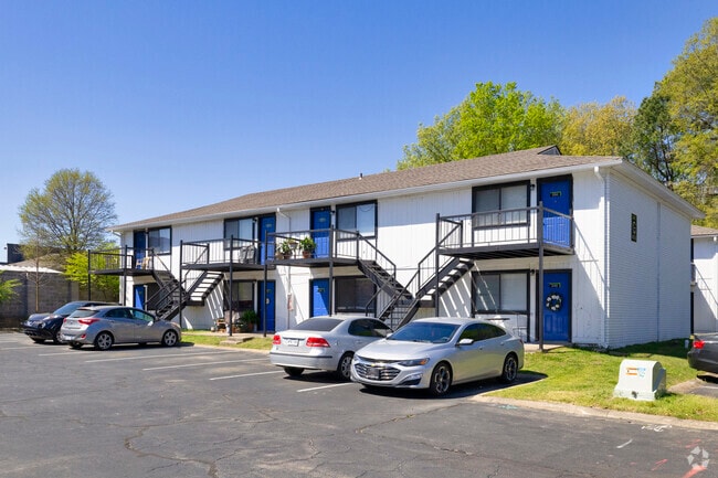
300 Indianhead Cv
Little Rock-North Little Rock-Conway, AR
Indianhead Lakes Est
22S-007-00-004-00
INDIAN HEAD LAKES EST REP A1 & LTS 282 THRU 290 & 20ALLEY AS A10
Laundromat
Pulaski
X
Arkansas
05119C0358G
a10
2025
4.51 AC
2025
Jacksonville/Sherwood
003707
Little Rock/N Little Rock
26,334 SF
DEMOGRAPHICS near 300 Indianhead Cv
1 Mile
3 Mile
5 Mile
2024 Total Population
6,479
32,933
76,193
2029 Population
6,461
32,775
75,962
Pop Growth 2024-2029
(0.28%)
(0.48%)
(0.30%)
Average Age
39
40
39
2024 Total Households
2,780
13,773
31,928
HH Growth 2024-2029
(0.36%)
(0.56%)
(0.29%)
Median Household Inc
$52,418
$65,601
$58,711
Avg Household Size
2.30
2.30
2.30
2024 Avg HH Vehicles
2.00
2.00
2.00
Median Home Value
$188,257
$178,616
$174,927
Median Year Built
1987
1985
1981
Nearby Places
Map Layers
Map Styles
 Street
 Aerial
- Restaurants
- Banks
- Shops
- Fitness
- Groceries
PUBLIC TRANSPORTATION
COMMUTER RAIL
Little Rock Union Station (Texas Eagle - Amtrak)
DRIVE
WALK
Distance
Little Rock Union Station (Texas Eagle - Amtrak)
15 min
9.9 mi
AIRPORT
Bill and Hillary Clinton Ntl/Adams Field
DRIVE
WALK
Distance
Bill and Hillary Clinton Ntl/Adams Field
19 min
14.4 mi
Freight Ports
Port of Shreveport
DRIVE
WALK
Distance
Port of Shreveport
262 min
242.4 mi
Nearby Properties
Address
Land Use
TOTAL SIZE
Lot Size
Zoning
Address
Land Use
TOTAL SIZE
Lot Size
Zoning
72,806 SF
10.95 AC
Address
Land Use
TOTAL SIZE
Lot Size
Zoning
17,352 SF
42.55 AC
Address
Land Use
TOTAL SIZE
Lot Size
Zoning
38,202 SF
14.23 AC
Address
Land Use
TOTAL SIZE
Lot Size
Zoning
36,934 SF
15.06 AC
Address
Land Use
TOTAL SIZE
Lot Size
Zoning
75,462 SF
5.33 AC
Address
Land Use
TOTAL SIZE
Lot Size
Zoning
72,157 SF
9.45 AC
Address
Land Use
TOTAL SIZE
Lot Size
Zoning
31,644 SF
Address
Land Use
TOTAL SIZE
Lot Size
Zoning
56,643 SF
9.46 AC
Address
Land Use
TOTAL SIZE
Lot Size
Zoning
28,947 SF
8.29 AC
Address
Land Use
TOTAL SIZE
Lot Size
Zoning
60,539 SF
2.95 AC
Address
Land Use
TOTAL SIZE
Lot Size
Zoning
45,500 SF
12.07 AC
Address
Land Use
TOTAL SIZE
Lot Size
Zoning
100,163 SF
15.51 AC
Address
Land Use
TOTAL SIZE
Lot Size
Zoning
145,604 SF
12.62 AC
Address
Land Use
TOTAL SIZE
Lot Size
Zoning
32,788 SF
3.99 AC
Address
Land Use
TOTAL SIZE
Lot Size
Zoning
33,597 SF
Address
Land Use
TOTAL SIZE
Lot Size
Zoning
141,664 SF
12.21 AC
Address
Land Use
TOTAL SIZE
Lot Size
Zoning
44,092 SF
7.97 AC
Address
Land Use
TOTAL SIZE
Lot Size
Zoning
54,401 SF
1.68 AC
Address
Land Use
TOTAL SIZE
Lot Size
Zoning
40,065 SF
8.26 AC
Address
Land Use
TOTAL SIZE
Lot Size
Zoning
75,064 SF
5.78 AC
Address
Land Use
TOTAL SIZE
Lot Size
Zoning
35,645 SF
7.97 AC
Address
Land Use
TOTAL SIZE
Lot Size
Zoning
9,222 SF
6.58 AC
Address
Land Use
TOTAL SIZE
Lot Size
Zoning
17,622 SF
7.88 AC
Address
Land Use
TOTAL SIZE
Lot Size
Zoning
89,724 SF
7.60 AC
Address
Land Use
TOTAL SIZE
Lot Size
Zoning
19,514 SF
54.85 AC
Address
Land Use
TOTAL SIZE
Lot Size
Zoning
29,600 SF
4.43 AC
Address
Land Use
TOTAL SIZE
Lot Size
Zoning
12,990 SF
5.72 AC
Address
Land Use
TOTAL SIZE
Lot Size
Zoning
32,256 SF
6.22 AC
Address
Land Use
TOTAL SIZE
Lot Size
Zoning
97,980 SF
5.89 AC
The World's #1 Commercial Real Estate Marketplace
Connect with us
© 2026 CoStar Group
The information above has been obtained from sources believed reliable. While we do not doubt its accuracy we have not verified it and make no guarantee, warranty or representation about it. It is your responsibility to independently confirm its accuracy and completeness. Any projections, opinions, assumptions, or estimates used are for example only and do not represent the current or future performance of the property. The value of this transaction to you depends on tax and other factors which should be evaluated by your tax, financial, and legal advisors. You and your advisors should conduct a careful, independent investigation of the property to determine to your satisfaction the suitability of the property for your needs.