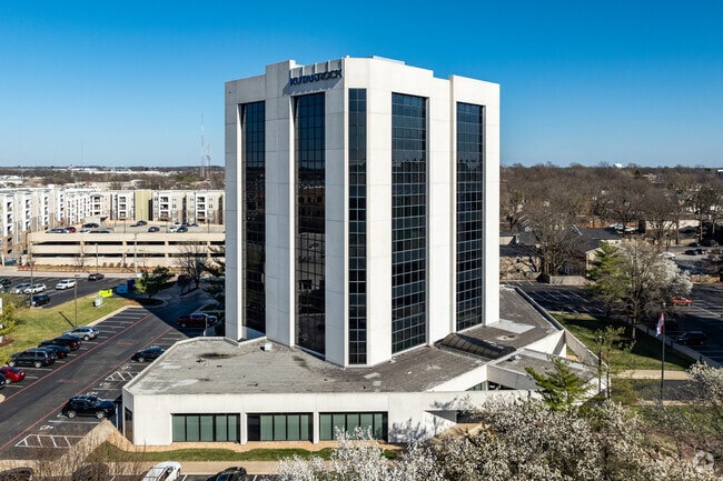
Property Record
300 S John Q Hammons Pky, Springfield, MO 65806


Current Lease Availabilities
NEARBY LISTINGS FOR SALE OR LEASE
Property Detail
300 S John Q Hammons Pky
Springfield, MO
University Plaza 1St Add
13-24-113-115
UNIVERSITY PLAZA 1ST ADD BEG 133.96 M/L S NW COR LOT 1 SLY A LG W LN UNIVERSITYPLAZA 1ST ADD TO NW COR ONE PARKWAY PLACE E 170.93 FT S 90 FT E 227 FT N 141.58FT E 18.37 FT N 330.72
Officebuilding
Greene
X
Missouri
29077C0334E
1
2025
3.45 AC
2025
CBD/Center City
000900
Springfield
73,930 SF
DEMOGRAPHICS near 300 S John Q Hammons Pky
1 Mile
3 Mile
5 Mile
2024 Total Population
17,792
95,727
177,383
2029 Population
18,595
99,960
184,477
Pop Growth 2024-2029
+ 4.51%
+ 4.42%
+ 4.00%
Average Age
30
36
38
2024 Total Households
7,671
42,212
78,686
HH Growth 2024-2029
+ 5.14%
+ 4.79%
+ 4.25%
Median Household Inc
$27,403
$38,845
$44,686
Avg Household Size
1.70
2.00
2.10
2024 Avg HH Vehicles
1.00
2.00
2.00
Median Home Value
$173,013
$119,633
$155,616
Median Year Built
1974
1969
1977
Nearby Places
Map Layers
Map Styles
 Street
 Aerial
- Restaurants
- Banks
- Shops
- Fitness
- Groceries
PUBLIC TRANSPORTATION
AIRPORT
Springfield-Branson Ntl
DRIVE
WALK
Distance
Springfield-Branson Ntl
25 min
9.8 mi
Nearby Properties
Address
Land Use
TOTAL SIZE
Lot Size
Zoning
Address
Land Use
TOTAL SIZE
Lot Size
Zoning
11.54 AC
Address
Land Use
TOTAL SIZE
Lot Size
Zoning
2,981,315 SF
76.43 AC
INC
Address
Land Use
TOTAL SIZE
Lot Size
Zoning
35.56 AC
INC
Address
Land Use
TOTAL SIZE
Lot Size
Zoning
343,758 SF
29.81 AC
INC
Address
Land Use
TOTAL SIZE
Lot Size
Zoning
297,760 SF
4.22 AC
INC
Address
Land Use
TOTAL SIZE
Lot Size
Zoning
233,445 SF
8.17 AC
INC
Address
Land Use
TOTAL SIZE
Lot Size
Zoning
1,728,457 SF
123.60 AC
INC
Address
Land Use
TOTAL SIZE
Lot Size
Zoning
12.35 AC
INC
Address
Land Use
TOTAL SIZE
Lot Size
Zoning
23.75 AC
Address
Land Use
TOTAL SIZE
Lot Size
Zoning
779,221 SF
45.03 AC
INC
Address
Land Use
TOTAL SIZE
Lot Size
Zoning
340,000 SF
37.93 AC
INC
Address
Land Use
TOTAL SIZE
Lot Size
Zoning
224,730 SF
19.99 AC
INC
Address
Land Use
TOTAL SIZE
Lot Size
Zoning
355,759 SF
2.23 AC
INC
Address
Land Use
TOTAL SIZE
Lot Size
Zoning
10.29 AC
INC.
Address
Land Use
TOTAL SIZE
Lot Size
Zoning
13.88 AC
INC
Address
Land Use
TOTAL SIZE
Lot Size
Zoning
1,825 SF
4.31 AC
INC
Address
Land Use
TOTAL SIZE
Lot Size
Zoning
25.51 AC
INC
Address
Land Use
TOTAL SIZE
Lot Size
Zoning
5.47 AC
INC
Address
Land Use
TOTAL SIZE
Lot Size
Zoning
253,781 SF
9.65 AC
INC
Address
Land Use
TOTAL SIZE
Lot Size
Zoning
143,774 SF
5.85 AC
INC
Address
Land Use
TOTAL SIZE
Lot Size
Zoning
1.99 AC
INC
Address
Land Use
TOTAL SIZE
Lot Size
Zoning
108,153 SF
7.37 AC
INC.
Address
Land Use
TOTAL SIZE
Lot Size
Zoning
290,844 SF
20.78 AC
INC
Address
Land Use
TOTAL SIZE
Lot Size
Zoning
324,341 SF
43 AC
INC
Address
Land Use
TOTAL SIZE
Lot Size
Zoning
20.11 AC
INC
Address
Land Use
TOTAL SIZE
Lot Size
Zoning
16.73 AC
Address
Land Use
TOTAL SIZE
Lot Size
Zoning
16.41 AC
INC
Address
Land Use
TOTAL SIZE
Lot Size
Zoning
116,085 SF
3.45 AC
INC
Address
Land Use
TOTAL SIZE
Lot Size
Zoning
2.92 AC
INC
Address
Land Use
TOTAL SIZE
Lot Size
Zoning
4.62 AC
INC
The World's #1 Commercial Real Estate Marketplace
Connect with us
© 2025 CoStar Group
The information above has been obtained from sources believed reliable. While we do not doubt its accuracy we have not verified it and make no guarantee, warranty or representation about it. It is your responsibility to independently confirm its accuracy and completeness. Any projections, opinions, assumptions, or estimates used are for example only and do not represent the current or future performance of the property. The value of this transaction to you depends on tax and other factors which should be evaluated by your tax, financial, and legal advisors. You and your advisors should conduct a careful, independent investigation of the property to determine to your satisfaction the suitability of the property for your needs.