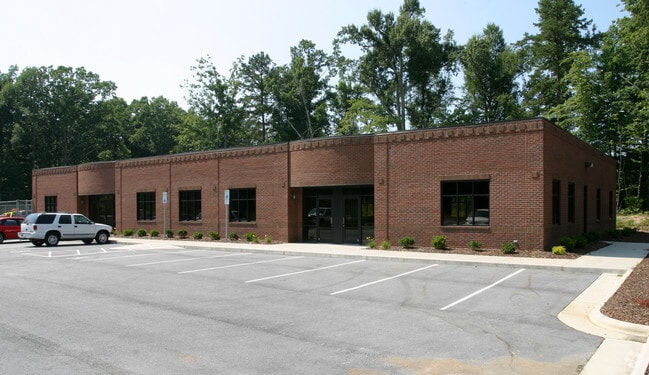
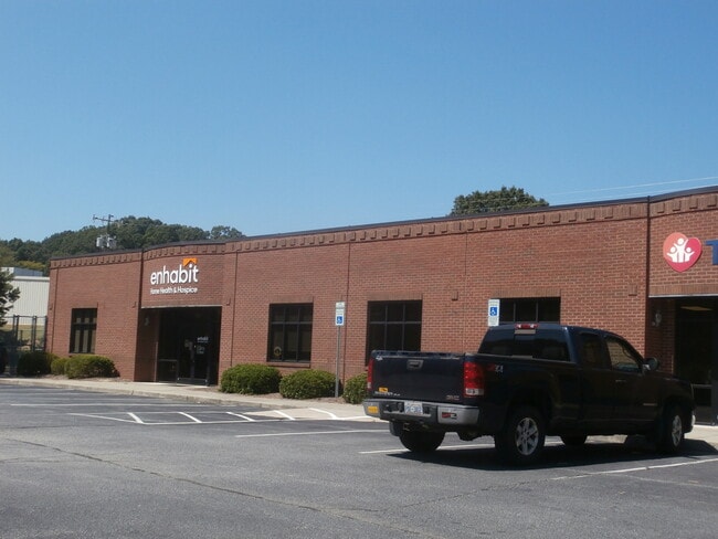
Property Record
300 Mack Rd, Asheboro, NC 27205

Property Detail
300 Mack Rd
7750-04-7590
J B HARRISON PROP LLC TR:1 PL:72-59
Medicalbuilding
Randolph
B2
North Carolina
B and X Area of moderate flood hazard, usually the area between the limits of the 100-year and 500-year floods.
2.26 AC
2025
SW Randolph County
2025
Greensboro/Winston-Salem
030600
Greensboro-High Point, NC
7,808 SF
NEARBY LISTINGS FOR SALE OR LEASE
DEMOGRAPHICS near 300 Mack Rd
1 mile
3 mile
5 mile
2025 Total Population
3,019
22,320
36,980
2030 Population
3,091
22,820
37,842
Pop Growth 2025-2030
+ 2.38%
+ 2.24%
+ 2.33%
Average Age
42
41
41
2025 Total Households
1,267
9,171
14,687
HH Growth 2025-2030
+ 2.53%
+ 2.30%
+ 2.38%
Median Household Inc
$51,075
$48,601
$52,049
Avg Household Size
2.20
2.30
2.40
2025 Avg HH Vehicles
2.00
2.00
2.00
Median Home Value
$216,585
$221,911
$226,057
Median Year Built
1976
1972
1977
Nearby Places
Map Layers
Map Styles
 Street
 Aerial
Layers
 Traffic
 Biking
Places
Listings with unknown addresses are not visible on the map
- Restaurants
- Banks
- Shops
- Fitness
- Groceries
PUBLIC TRANSPORTATION
AIRPORT
Piedmont Triad International
Drive
Walk
Distance
Piedmont Triad International
46 min
34.7 mi
Freight Ports
Port of Wilmington
Drive
Walk
Distance
Port of Wilmington
222 min
187.7 mi
SALE & LEASE HISTORY
LISTING DATE
SALE/LEASE

Sep 25, 2016
For Lease
Sep 23, 2016
For Sale
Sep 05, 2023
For Sale
Nov 19, 2019
For Sale
Nearby Properties
Address
Land Use
TOTAL SIZE
Lot Size
Zoning
Address
Land Use
TOTAL SIZE
Lot Size
Zoning
312,205 SF
6.83 AC
B2
Address
Land Use
TOTAL SIZE
Lot Size
Zoning
3,196 SF
24.89 AC
RA6 (CZ)
Address
Land Use
TOTAL SIZE
Lot Size
Zoning
221,524 SF
22.11 AC
B2 (CZ)
Address
Land Use
TOTAL SIZE
Lot Size
Zoning
24.92 AC
B2
Address
Land Use
TOTAL SIZE
Lot Size
Zoning
5.24 AC
B3
Address
Land Use
TOTAL SIZE
Lot Size
Zoning
111,408 SF
125.85 AC
I3 (CZ)
Address
Land Use
TOTAL SIZE
Lot Size
Zoning
44,912 SF
25.15 AC
I1
Address
Land Use
TOTAL SIZE
Lot Size
Zoning
75,251 SF
18.75 AC
B2 (CZ)
Address
Land Use
TOTAL SIZE
Lot Size
Zoning
720 SF
62.64 AC
HI-CD
Address
Land Use
TOTAL SIZE
Lot Size
Zoning
84,329 SF
71.50 AC
I2
Address
Land Use
TOTAL SIZE
Lot Size
Zoning
94,956 SF
15.15 AC
B2
Address
Land Use
TOTAL SIZE
Lot Size
Zoning
52,741 SF
2.53 AC
B2
Address
Land Use
TOTAL SIZE
Lot Size
Zoning
52,741 SF
2.15 AC
B2
Address
Land Use
TOTAL SIZE
Lot Size
Zoning
136,877 SF
25.59 AC
I1
Address
Land Use
TOTAL SIZE
Lot Size
Zoning
193,214 SF
17.06 AC
I1
Address
Land Use
TOTAL SIZE
Lot Size
Zoning
35,502 SF
2.83 AC
B2
Address
Land Use
TOTAL SIZE
Lot Size
Zoning
4,590 SF
15.50 AC
RA6
Address
Land Use
TOTAL SIZE
Lot Size
Zoning
18,144 SF
2.91 AC
B2
Address
Land Use
TOTAL SIZE
Lot Size
Zoning
47,797 SF
2.61 AC
B2 (CZ)
Address
Land Use
TOTAL SIZE
Lot Size
Zoning
5.58 AC
B2
Address
Land Use
TOTAL SIZE
Lot Size
Zoning
43,046 SF
4.09 AC
B2
Address
Land Use
TOTAL SIZE
Lot Size
Zoning
59,830 SF
0.85 AC
RA6
Address
Land Use
TOTAL SIZE
Lot Size
Zoning
75,024 SF
2.02 AC
B2
Address
Land Use
TOTAL SIZE
Lot Size
Zoning
8,614 SF
7.40 AC
RA6
Address
Land Use
TOTAL SIZE
Lot Size
Zoning
66,585 SF
7.16 AC
OA6
Address
Land Use
TOTAL SIZE
Lot Size
Zoning
13,888 SF
3.43 AC
B1 (CZ)
Address
Land Use
TOTAL SIZE
Lot Size
Zoning
76,560 SF
7.12 AC
B2
Address
Land Use
TOTAL SIZE
Lot Size
Zoning
24.22 AC
I1
Address
Land Use
TOTAL SIZE
Lot Size
Zoning
22,810 SF
2.92 AC
B2
Address
Land Use
TOTAL SIZE
Lot Size
Zoning
52,901 SF
6.11 AC
B2
The World's #1 Commercial Real Estate Marketplace
Connect with us
© 2026 CoStar Group
The information above has been obtained from sources believed reliable. While we do not doubt its accuracy we have not verified it and make no guarantee, warranty or representation about it. It is your responsibility to independently confirm its accuracy and completeness. Any projections, opinions, assumptions, or estimates used are for example only and do not represent the current or future performance of the property. The value of this transaction to you depends on tax and other factors which should be evaluated by your tax, financial, and legal advisors. You and your advisors should conduct a careful, independent investigation of the property to determine to your satisfaction the suitability of the property for your needs.