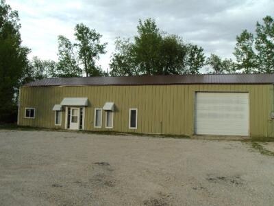
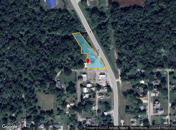
Property Record
300 Main St N, Hazleton, IA 50641
NEARBY LISTINGS FOR SALE OR LEASE
-
-
View all Hazleton listings for sale on LoopNet.com
Property Detail
300 Main St N
Commercialnec
COM 33'ERLY OF CTRLN3 RD ST ON N LN NORTHST E60' TO POB N150'W60 ' N65.8' NW30.6' NW21 0.6' NW422.36' SE359. 5' SE37.6' SE216
A
Buchanan
19019C0156E
Iowa
2024
0.85 AC
2025
Iowa Northeast Area
950200
Other Market Areas
672 SF
02.09.200.036
DEMOGRAPHICS near 300 Main St N
1 Mile
3 Mile
5 Mile
2024 Total Population
978
1,724
8,233
2029 Population
1,006
1,756
8,227
Pop Growth 2024-2029
+ 2.86%
+ 1.86%
(0.07%)
Average Age
39
41
42
2024 Total Households
383
697
3,463
HH Growth 2024-2029
+ 2.87%
+ 1.58%
(0.17%)
Median Household Inc
$54,846
$50,204
$43,196
Avg Household Size
2.50
2.40
2.20
2024 Avg HH Vehicles
3.00
2.00
2.00
Median Home Value
$127,586
$106,329
$103,708
Median Year Built
1974
1972
1958
Nearby Places
Map Layers
Map Styles
 Street
 Aerial
- Restaurants
- Banks
- Shops
- Fitness
- Groceries
Nearby Properties
Address
Land Use
TOTAL SIZE
Lot Size
Zoning
Address
Land Use
TOTAL SIZE
Lot Size
Zoning
140 SF
28.27 AC
Address
Land Use
TOTAL SIZE
Lot Size
Zoning
13,586 SF
10 AC
Address
Land Use
TOTAL SIZE
Lot Size
Zoning
2,600 SF
4.77 AC
Address
Land Use
TOTAL SIZE
Lot Size
Zoning
9,232 SF
4.10 AC
Address
Land Use
TOTAL SIZE
Lot Size
Zoning
58,764 SF
9.87 AC
Address
Land Use
TOTAL SIZE
Lot Size
Zoning
1,800 SF
6.05 AC
Address
Land Use
TOTAL SIZE
Lot Size
Zoning
59,910 SF
9.64 AC
Address
Land Use
TOTAL SIZE
Lot Size
Zoning
11,837 SF
5.26 AC
Address
Land Use
TOTAL SIZE
Lot Size
Zoning
9,988 SF
2.87 AC
Address
Land Use
TOTAL SIZE
Lot Size
Zoning
684 SF
8.09 AC
Address
Land Use
TOTAL SIZE
Lot Size
Zoning
40,480 SF
4.21 AC
Address
Land Use
TOTAL SIZE
Lot Size
Zoning
4,758 SF
12.95 AC
Address
Land Use
TOTAL SIZE
Lot Size
Zoning
39,600 SF
4.52 AC
Address
Land Use
TOTAL SIZE
Lot Size
Zoning
6,000 SF
1.78 AC
Address
Land Use
TOTAL SIZE
Lot Size
Zoning
16,458 SF
1.68 AC
Address
Land Use
TOTAL SIZE
Lot Size
Zoning
16,200 SF
9.19 AC
Address
Land Use
TOTAL SIZE
Lot Size
Zoning
624 SF
9.90 AC
Address
Land Use
TOTAL SIZE
Lot Size
Zoning
11,538 SF
2.59 AC
Address
Land Use
TOTAL SIZE
Lot Size
Zoning
65.33 AC
Address
Land Use
TOTAL SIZE
Lot Size
Zoning
2,635 SF
2.17 AC
Address
Land Use
TOTAL SIZE
Lot Size
Zoning
7,200 SF
2.54 AC
Address
Land Use
TOTAL SIZE
Lot Size
Zoning
768 SF
10.43 AC
Address
Land Use
TOTAL SIZE
Lot Size
Zoning
5,152 SF
1.75 AC
Address
Land Use
TOTAL SIZE
Lot Size
Zoning
6,000 SF
4.62 AC
Address
Land Use
TOTAL SIZE
Lot Size
Zoning
15,744 SF
1.97 AC
Address
Land Use
TOTAL SIZE
Lot Size
Zoning
2,040 SF
0.27 AC
Address
Land Use
TOTAL SIZE
Lot Size
Zoning
17,300 SF
1.91 AC
Address
Land Use
TOTAL SIZE
Lot Size
Zoning
4,132 SF
0.75 AC
Address
Land Use
TOTAL SIZE
Lot Size
Zoning
153.41 AC
Address
Land Use
TOTAL SIZE
Lot Size
Zoning
841 SF
3.98 AC
The World's #1 Commercial Real Estate Marketplace
Connect with us
© 2026 CoStar Group
The information above has been obtained from sources believed reliable. While we do not doubt its accuracy we have not verified it and make no guarantee, warranty or representation about it. It is your responsibility to independently confirm its accuracy and completeness. Any projections, opinions, assumptions, or estimates used are for example only and do not represent the current or future performance of the property. The value of this transaction to you depends on tax and other factors which should be evaluated by your tax, financial, and legal advisors. You and your advisors should conduct a careful, independent investigation of the property to determine to your satisfaction the suitability of the property for your needs.