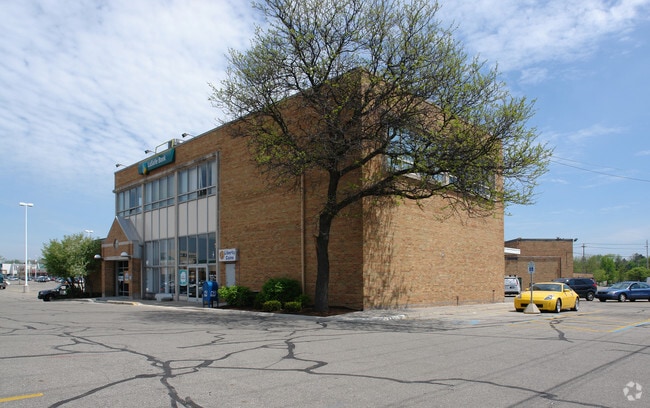
Property Record
300 Frandor Ave, Lansing, MI 48912
NEARBY LISTINGS FOR SALE OR LEASE
Property Detail
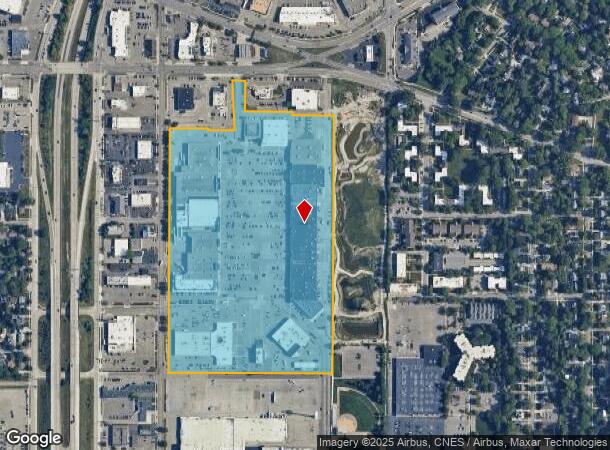
300 Frandor Ave
01-01-14-226-015
E 1/2 OF NE 1/4 SEC 14 EXC E 1/4 THEREOF, ALSO EXC LANDS S OF A LINE 850 FT N OF N LINE MICHIGAN AVE, ALSO EXC LANDS LYING N'LY OF A LINE BEG 327.32 FT W OF NE COR POST SEC 14, TH S 236.73 FT, W 237.61 FT, N 19.07 FT, W 278 FT, N 176.16 FT TO S LINE
Stripcommercialcenter
Ingham
AE
Michigan
26065C0132D
32 AC
2024
East Lansing
2025
West Michigan
004000
Lansing-East Lansing, MI
63,461 SF
DEMOGRAPHICS near 300 Frandor Ave
1 Mile
3 Mile
5 Mile
2024 Total Population
15,594
91,205
171,598
2029 Population
15,683
91,685
172,006
Pop Growth 2024-2029
+ 0.57%
+ 0.53%
+ 0.24%
Average Age
34
34
36
2024 Total Households
7,158
39,828
74,999
HH Growth 2024-2029
+ 0.50%
+ 0.55%
+ 0.20%
Median Household Inc
$45,890
$41,339
$49,088
Avg Household Size
2.00
2.10
2.10
2024 Avg HH Vehicles
2.00
1.00
2.00
Median Home Value
$161,236
$152,570
$150,574
Median Year Built
1963
1968
1967
Nearby Places
Map Layers
Map Styles
 Street
 Aerial
- Restaurants
- Banks
- Shops
- Fitness
- Groceries
PUBLIC TRANSPORTATION
COMMUTER RAIL
DRIVE
WALK
Distance
7 min
2.4 mi
AIRPORT
Capital Region International
DRIVE
WALK
Distance
Capital Region International
14 min
5.9 mi
SALE & LEASE HISTORY
LISTING DATE
SALE/LEASE

Mar 23, 2017
For Lease
Nearby Properties
Address
Land Use
TOTAL SIZE
Lot Size
Zoning
Address
Land Use
TOTAL SIZE
Lot Size
Zoning
312,651 SF
37.50 AC
D-1 PRO
Address
Land Use
TOTAL SIZE
Lot Size
Zoning
42,875 SF
35 AC
PD
Address
Land Use
TOTAL SIZE
Lot Size
Zoning
66,818 SF
0.99 AC
EV
Address
Land Use
TOTAL SIZE
Lot Size
Zoning
7,579 SF
83.53 AC
PD
Address
Land Use
TOTAL SIZE
Lot Size
Zoning
42,875 SF
28.77 AC
Address
Land Use
TOTAL SIZE
Lot Size
Zoning
111,180 SF
3.63 AC
G-1 BUS
Address
Land Use
TOTAL SIZE
Lot Size
Zoning
14,304 SF
3.37 AC
MIXED Z
Address
Land Use
TOTAL SIZE
Lot Size
Zoning
49,959 SF
15.71 AC
RP
Address
Land Use
TOTAL SIZE
Lot Size
Zoning
222,869 SF
0.10 AC
B3
Address
Land Use
TOTAL SIZE
Lot Size
Zoning
98,513 SF
7.86 AC
C-2
Address
Land Use
TOTAL SIZE
Lot Size
Zoning
274,720 SF
10.55 AC
Address
Land Use
TOTAL SIZE
Lot Size
Zoning
73,179 SF
58.17 AC
RM14
Address
Land Use
TOTAL SIZE
Lot Size
Zoning
12,435 SF
0.52 AC
B3
Address
Land Use
TOTAL SIZE
Lot Size
Zoning
177,300 SF
8.72 AC
Address
Land Use
TOTAL SIZE
Lot Size
Zoning
69,851 SF
134.23 AC
I HVY
Address
Land Use
TOTAL SIZE
Lot Size
Zoning
13.13 AC
Address
Land Use
TOTAL SIZE
Lot Size
Zoning
66.43 AC
Address
Land Use
TOTAL SIZE
Lot Size
Zoning
179,376 SF
6.03 AC
RM32
Address
Land Use
TOTAL SIZE
Lot Size
Zoning
16,466 SF
14.82 AC
DEVELOPMEN
Address
Land Use
TOTAL SIZE
Lot Size
Zoning
195,094 SF
1.89 AC
Address
Land Use
TOTAL SIZE
Lot Size
Zoning
19,035 SF
12.32 AC
RM08
Address
Land Use
TOTAL SIZE
Lot Size
Zoning
20,438 SF
17.81 AC
DEVELOPMEN
Address
Land Use
TOTAL SIZE
Lot Size
Zoning
188,175 SF
4.37 AC
EV
Address
Land Use
TOTAL SIZE
Lot Size
Zoning
185,190 SF
0.41 AC
G-1 BUS
Address
Land Use
TOTAL SIZE
Lot Size
Zoning
215,335 SF
38.10 AC
RM08
Address
Land Use
TOTAL SIZE
Lot Size
Zoning
300,760 SF
27.22 AC
RM08
Address
Land Use
TOTAL SIZE
Lot Size
Zoning
129,030 SF
RP
Address
Land Use
TOTAL SIZE
Lot Size
Zoning
61,198 SF
13.10 AC
C-2
Address
Land Use
TOTAL SIZE
Lot Size
Zoning
150,589 SF
3.06 AC
D-1 PRO
The World's #1 Commercial Real Estate Marketplace
Connect with us
© 2025 CoStar Group
The information above has been obtained from sources believed reliable. While we do not doubt its accuracy we have not verified it and make no guarantee, warranty or representation about it. It is your responsibility to independently confirm its accuracy and completeness. Any projections, opinions, assumptions, or estimates used are for example only and do not represent the current or future performance of the property. The value of this transaction to you depends on tax and other factors which should be evaluated by your tax, financial, and legal advisors. You and your advisors should conduct a careful, independent investigation of the property to determine to your satisfaction the suitability of the property for your needs.