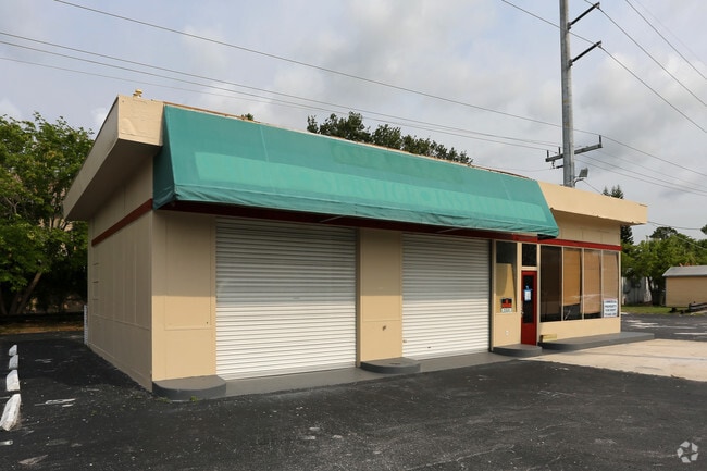
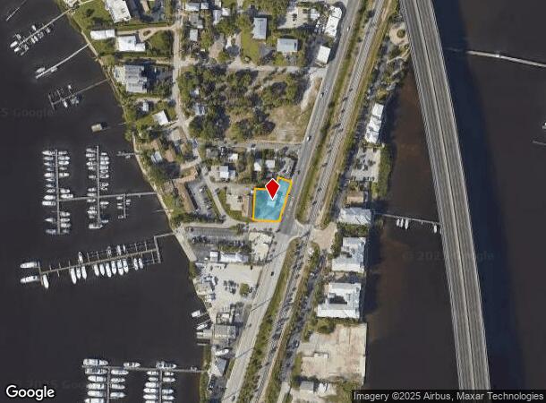
Property Record
300 N Dixie Hwy, Stuart, FL 34994

NEARBY LISTINGS FOR SALE OR LEASE
Property Detail
300 N Dixie Hwy
Port St. Lucie, FL
Riverside Park
32-37-41-004-003-00050-8
LOTS 5 THROUGH 11 BLOCK C AND THAT PART OF THE 20 FOOT ALLEY WEST OF LOTS 6 THROUGH 10 BLOCK C RIVERSIDE PARK ACCORDING TO THE PLAT THEREOF AS RECORDED IN PLAT BOOK 4 PAGE 98 PUBLIC RECORDS OF ST LUCIE NOW MARTIN COUNTY FLORIDA LESS THAT PORTION DEDI
Commercialnec
Martin
X
Florida
12085C0134H
5
2024
0.39 AC
2025
Port St Lucie
000300
Port St Lucie/Fort Pierce
1,372 SF
DEMOGRAPHICS near 300 N Dixie Hwy
1 mile
3 mile
5 mile
2024 Total Population
3,074
45,941
105,946
2029 Population
3,223
48,958
115,276
Pop Growth 2024-2029
+ 4.85%
+ 6.57%
+ 8.81%
Average Age
49
49
48
2024 Total Households
1,485
21,101
46,611
HH Growth 2024-2029
+ 4.78%
+ 6.59%
+ 8.73%
Median Household Inc
$66,730
$60,692
$66,916
Avg Household Size
2.00
2.10
2.20
2024 Avg HH Vehicles
2.00
2.00
2.00
Median Home Value
$476,973
$327,647
$333,356
Median Year Built
1980
1983
1986
Nearby Places
Map Layers
Map Styles
 Street
 Aerial
Transit
 Traffic
 Biking
Places
Listings with unknown addresses are not visible on the map
- Restaurants
- Banks
- Shops
- Fitness
- Groceries
Nearby Properties
Address
Land Use
TOTAL SIZE
Lot Size
Zoning
Address
Land Use
TOTAL SIZE
Lot Size
Zoning
609,195 SF
13.77 AC
H
Address
Land Use
TOTAL SIZE
Lot Size
Zoning
481,508 SF
59.41 AC
PUDC
Address
Land Use
TOTAL SIZE
Lot Size
Zoning
11.34 AC
Address
Land Use
TOTAL SIZE
Lot Size
Zoning
292,279 SF
65.79 AC
R2
Address
Land Use
TOTAL SIZE
Lot Size
Zoning
309,031 SF
76.74 AC
RPUD
Address
Land Use
TOTAL SIZE
Lot Size
Zoning
378,814 SF
34.25 AC
PUDR
Address
Land Use
TOTAL SIZE
Lot Size
Zoning
14.86 AC
M1
Address
Land Use
TOTAL SIZE
Lot Size
Zoning
310,460 SF
48.85 AC
PS2
Address
Land Use
TOTAL SIZE
Lot Size
Zoning
6.66 AC
RPUD
Address
Land Use
TOTAL SIZE
Lot Size
Zoning
23.08 AC
RM8
Address
Land Use
TOTAL SIZE
Lot Size
Zoning
9.45 AC
RS6
Address
Land Use
TOTAL SIZE
Lot Size
Zoning
160,211 SF
17.44 AC
CPUD
Address
Land Use
TOTAL SIZE
Lot Size
Zoning
195,729 SF
20.25 AC
CPUD
Address
Land Use
TOTAL SIZE
Lot Size
Zoning
545,151 SF
62.49 AC
PAF
Address
Land Use
TOTAL SIZE
Lot Size
Zoning
127,238 SF
3.62 AC
P
Address
Land Use
TOTAL SIZE
Lot Size
Zoning
106,357 SF
22.96 AC
Address
Land Use
TOTAL SIZE
Lot Size
Zoning
189,035 SF
20.63 AC
R3
Address
Land Use
TOTAL SIZE
Lot Size
Zoning
196,180 SF
18.71 AC
B1
Address
Land Use
TOTAL SIZE
Lot Size
Zoning
175,170 SF
19.53 AC
B1
Address
Land Use
TOTAL SIZE
Lot Size
Zoning
1,050 SF
5.33 AC
R3
Address
Land Use
TOTAL SIZE
Lot Size
Zoning
23,640 SF
15.28 AC
B2
Address
Land Use
TOTAL SIZE
Lot Size
Zoning
124,082 SF
4.60 AC
P
Address
Land Use
TOTAL SIZE
Lot Size
Zoning
10,520 SF
88.85 AC
TP
Address
Land Use
TOTAL SIZE
Lot Size
Zoning
2,221 SF
18.12 AC
R3A
Address
Land Use
TOTAL SIZE
Lot Size
Zoning
2,400 SF
7.31 AC
INDUST
Address
Land Use
TOTAL SIZE
Lot Size
Zoning
116,258 SF
14.58 AC
R3
Address
Land Use
TOTAL SIZE
Lot Size
Zoning
259,952 SF
25.50 AC
PS
Address
Land Use
TOTAL SIZE
Lot Size
Zoning
204,538 SF
22.65 AC
P
Address
Land Use
TOTAL SIZE
Lot Size
Zoning
152,826 SF
15 AC
B2
Address
Land Use
TOTAL SIZE
Lot Size
Zoning
198,758 SF
39.92 AC
RM5
The World's #1 Commercial Real Estate Marketplace
Connect with us
© 2026 CoStar Group
The information above has been obtained from sources believed reliable. While we do not doubt its accuracy we have not verified it and make no guarantee, warranty or representation about it. It is your responsibility to independently confirm its accuracy and completeness. Any projections, opinions, assumptions, or estimates used are for example only and do not represent the current or future performance of the property. The value of this transaction to you depends on tax and other factors which should be evaluated by your tax, financial, and legal advisors. You and your advisors should conduct a careful, independent investigation of the property to determine to your satisfaction the suitability of the property for your needs.