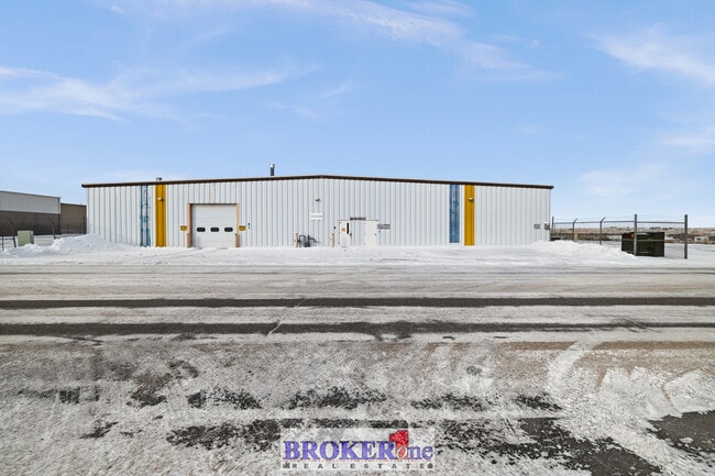
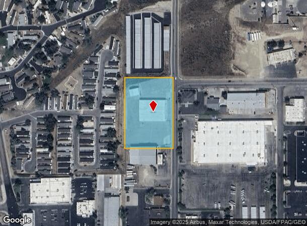
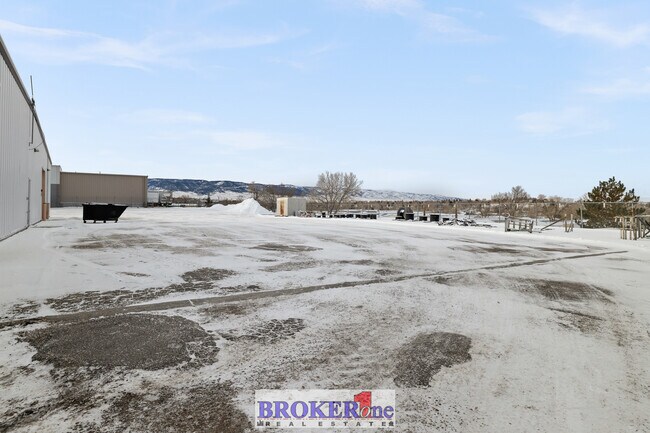
Property Record
300 N Walsh Dr, Casper, WY 82609
Current Lease Availabilities
NEARBY LISTINGS FOR SALE OR LEASE
Property Detail
300 N Walsh Dr
33-79-01-3-0-001100
PT SW SW: 1-33-79 COMMERCIAL
Warehouse
Natrona
X
Wyoming
56025C2007E
2.50 AC
2024
I-25 Corridor/Casper
2025
Other Market Areas
000502
Casper, WY
17,640 SF
DEMOGRAPHICS near 300 N Walsh Dr
1 Mile
3 Mile
5 Mile
2024 Total Population
8,042
38,418
55,363
2029 Population
8,140
39,090
56,320
Pop Growth 2024-2029
+ 1.22%
+ 1.75%
+ 1.73%
Average Age
39
40
40
2024 Total Households
3,306
16,561
23,364
HH Growth 2024-2029
+ 1.24%
+ 1.79%
+ 1.76%
Median Household Inc
$63,524
$60,286
$62,431
Avg Household Size
2.30
2.20
2.30
2024 Avg HH Vehicles
2.00
2.00
2.00
Median Home Value
$207,093
$229,415
$230,645
Median Year Built
1974
1974
1972
Nearby Places
Map Layers
Map Styles
 Street
 Aerial
- Restaurants
- Banks
- Shops
- Fitness
- Groceries
PUBLIC TRANSPORTATION
AIRPORT
Casper/Natrona County International
DRIVE
WALK
Distance
Casper/Natrona County International
32 min
17.3 mi
Freight Ports
Tulsa Port Of Catoosa
DRIVE
WALK
Distance
Tulsa Port Of Catoosa
989 min
975.2 mi
Nearby Properties
Address
Land Use
TOTAL SIZE
Lot Size
Zoning
Address
Land Use
TOTAL SIZE
Lot Size
Zoning
4,660 SF
13.18 AC
Address
Land Use
TOTAL SIZE
Lot Size
Zoning
23,532 SF
10.30 AC
Address
Land Use
TOTAL SIZE
Lot Size
Zoning
50,537 SF
8 AC
Address
Land Use
TOTAL SIZE
Lot Size
Zoning
12,674 SF
13.26 AC
Address
Land Use
TOTAL SIZE
Lot Size
Zoning
38,736 SF
8.91 AC
Address
Land Use
TOTAL SIZE
Lot Size
Zoning
4,384 SF
13.74 AC
Address
Land Use
TOTAL SIZE
Lot Size
Zoning
156,457 SF
5.74 AC
Address
Land Use
TOTAL SIZE
Lot Size
Zoning
102,996 SF
4.81 AC
Address
Land Use
TOTAL SIZE
Lot Size
Zoning
53,685 SF
4.28 AC
Address
Land Use
TOTAL SIZE
Lot Size
Zoning
16,924 SF
9.54 AC
Address
Land Use
TOTAL SIZE
Lot Size
Zoning
95,290 SF
0.57 AC
Address
Land Use
TOTAL SIZE
Lot Size
Zoning
99,524 SF
4.67 AC
Address
Land Use
TOTAL SIZE
Lot Size
Zoning
81,240 SF
5.86 AC
Address
Land Use
TOTAL SIZE
Lot Size
Zoning
585,921 SF
58.85 AC
Address
Land Use
TOTAL SIZE
Lot Size
Zoning
176,027 SF
17.49 AC
Address
Land Use
TOTAL SIZE
Lot Size
Zoning
52,040 SF
13.51 AC
Address
Land Use
TOTAL SIZE
Lot Size
Zoning
55,754 SF
1.23 AC
Address
Land Use
TOTAL SIZE
Lot Size
Zoning
166,099 SF
7.65 AC
Address
Land Use
TOTAL SIZE
Lot Size
Zoning
95,756 SF
3.15 AC
Address
Land Use
TOTAL SIZE
Lot Size
Zoning
89,892 SF
2.75 AC
Address
Land Use
TOTAL SIZE
Lot Size
Zoning
10,928 SF
6.90 AC
Address
Land Use
TOTAL SIZE
Lot Size
Zoning
206,796 SF
18.06 AC
Address
Land Use
TOTAL SIZE
Lot Size
Zoning
89,995 SF
6.68 AC
Address
Land Use
TOTAL SIZE
Lot Size
Zoning
68,887 SF
8.02 AC
Address
Land Use
TOTAL SIZE
Lot Size
Zoning
40,414 SF
0.03 AC
Address
Land Use
TOTAL SIZE
Lot Size
Zoning
36,379 SF
4.02 AC
Address
Land Use
TOTAL SIZE
Lot Size
Zoning
70,772 SF
11.68 AC
Address
Land Use
TOTAL SIZE
Lot Size
Zoning
110,360 SF
12.85 AC
Address
Land Use
TOTAL SIZE
Lot Size
Zoning
92,078 SF
5.52 AC
Address
Land Use
TOTAL SIZE
Lot Size
Zoning
68,174 SF
3.86 AC
The World's #1 Commercial Real Estate Marketplace
Connect with us
© 2026 CoStar Group
The information above has been obtained from sources believed reliable. While we do not doubt its accuracy we have not verified it and make no guarantee, warranty or representation about it. It is your responsibility to independently confirm its accuracy and completeness. Any projections, opinions, assumptions, or estimates used are for example only and do not represent the current or future performance of the property. The value of this transaction to you depends on tax and other factors which should be evaluated by your tax, financial, and legal advisors. You and your advisors should conduct a careful, independent investigation of the property to determine to your satisfaction the suitability of the property for your needs.