Property Record
300 Ne 7Th Ave, Oak Harbor, WA 98277


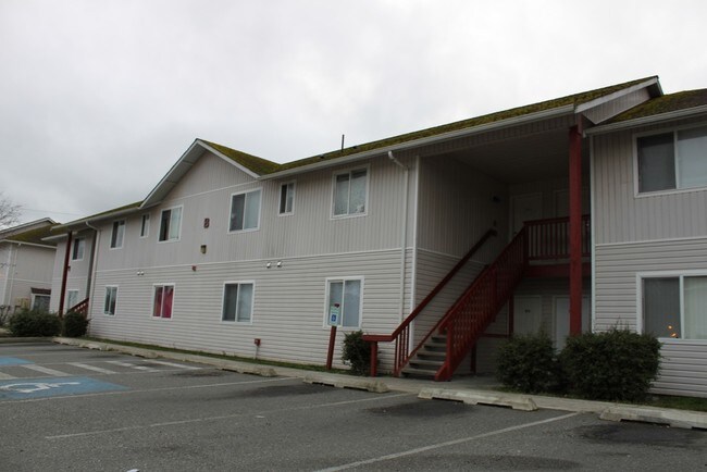
Property Detail
300 Ne 7Th Ave
R13335-279-1310
PORTION EXEMPT LOT 2 OH-SP 97-1.13335.275-1270 V3 SP P177 AF#97019436
Multifamilydwelling
Island
OH
Washington
C and X Area of minimal flood hazard, usually depicted on FIRMs as above the 500-year flood level.
2
0
1.69 AC
2025
Seattle North/Everett
970402
Other Market Areas
19,572 SF
Oak Harbor, WA
NEARBY LISTINGS FOR SALE OR LEASE
-
-
View all Oak Harbor listings for sale on LoopNet.com
DEMOGRAPHICS near 300 Ne 7Th Ave
1 mile
3 mile
5 mile
2025 Total Population
10,427
28,105
36,227
2030 Population
10,034
27,236
35,234
Pop Growth 2025-2030
(3.77%)
(3.09%)
(2.74%)
Average Age
38
36
38
2025 Total Households
4,396
10,344
13,425
HH Growth 2025-2030
(3.94%)
(3.37%)
(2.98%)
Median Household Inc
$68,646
$78,860
$83,163
Avg Household Size
2.30
2.50
2.50
2025 Avg HH Vehicles
2.00
2.00
2.00
Median Home Value
$413,853
$456,225
$480,050
Median Year Built
1982
1985
1985
Nearby Places
Map Layers
Map Styles
 Street
 Aerial
Layers
 Traffic
 Biking
Places
Listings with unknown addresses are not visible on the map
- Restaurants
- Banks
- Shops
- Fitness
- Groceries
PUBLIC TRANSPORTATION
AIRPORT
Seattle Paine Field International
Drive
Walk
Distance
Seattle Paine Field International
93 min
47.0 mi
Freight Ports
Drive
Walk
Distance
33 min
20.1 mi
Nearby Properties
Address
Land Use
TOTAL SIZE
Lot Size
Zoning
Address
Land Use
TOTAL SIZE
Lot Size
Zoning
273,742 SF
44.92 AC
OH
Address
Land Use
TOTAL SIZE
Lot Size
Zoning
83,018 SF
3.07 AC
OH
Address
Land Use
TOTAL SIZE
Lot Size
Zoning
121,642 SF
6.28 AC
OH
Address
Land Use
TOTAL SIZE
Lot Size
Zoning
94,005 SF
4.79 AC
OH
Address
Land Use
TOTAL SIZE
Lot Size
Zoning
87,878 SF
15.76 AC
OH
Address
Land Use
TOTAL SIZE
Lot Size
Zoning
70,705 SF
7.47 AC
OH
Address
Land Use
TOTAL SIZE
Lot Size
Zoning
19,160 SF
8.50 AC
50
Address
Land Use
TOTAL SIZE
Lot Size
Zoning
105,488 SF
11.32 AC
C-5
Address
Land Use
TOTAL SIZE
Lot Size
Zoning
101,703 SF
10.66 AC
OH
Address
Land Use
TOTAL SIZE
Lot Size
Zoning
57,924 SF
19.54 AC
OH
Address
Land Use
TOTAL SIZE
Lot Size
Zoning
41,845 SF
3.29 AC
OH
Address
Land Use
TOTAL SIZE
Lot Size
Zoning
24,800 SF
3.18 AC
OH
Address
Land Use
TOTAL SIZE
Lot Size
Zoning
27,618 SF
3.91 AC
OH
Address
Land Use
TOTAL SIZE
Lot Size
Zoning
41,180 SF
12.68 AC
OH
Address
Land Use
TOTAL SIZE
Lot Size
Zoning
84,128 SF
8.36 AC
50
Address
Land Use
TOTAL SIZE
Lot Size
Zoning
30,649 SF
3.14 AC
OH
Address
Land Use
TOTAL SIZE
Lot Size
Zoning
43,347 SF
2.04 AC
Address
Land Use
TOTAL SIZE
Lot Size
Zoning
39,068 SF
2.15 AC
OH
Address
Land Use
TOTAL SIZE
Lot Size
Zoning
32,776 SF
3.30 AC
OH
Address
Land Use
TOTAL SIZE
Lot Size
Zoning
15,512 SF
3.15 AC
OH
Address
Land Use
TOTAL SIZE
Lot Size
Zoning
75,050 SF
6.75 AC
Address
Land Use
TOTAL SIZE
Lot Size
Zoning
53,090 SF
1.71 AC
OH
Address
Land Use
TOTAL SIZE
Lot Size
Zoning
44,368 SF
4.53 AC
OH
Address
Land Use
TOTAL SIZE
Lot Size
Zoning
13,999 SF
1.47 AC
OH
Address
Land Use
TOTAL SIZE
Lot Size
Zoning
41,632 SF
2.41 AC
OH
The World's #1 Commercial Real Estate Marketplace
Connect with us
© 2026 CoStar Group
The information above has been obtained from sources believed reliable. While we do not doubt its accuracy we have not verified it and make no guarantee, warranty or representation about it. It is your responsibility to independently confirm its accuracy and completeness. Any projections, opinions, assumptions, or estimates used are for example only and do not represent the current or future performance of the property. The value of this transaction to you depends on tax and other factors which should be evaluated by your tax, financial, and legal advisors. You and your advisors should conduct a careful, independent investigation of the property to determine to your satisfaction the suitability of the property for your needs.