Property Record
300 Ne Autumn Rose Way, Hillsboro, OR 97124

Save to a Folder
{{folder.Name}}
{{folder.ListingIds.length}} Properties
{{folder.ListingIds.length}} Property
Create a New Folder
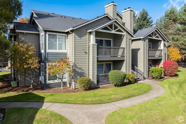
Property Detail
300 Ne Autumn Rose Way
Portland-Vancouver-Hillsboro, OR-WA
JACKSON SCHOOL NO.3 (A REPLAT OF HARE-WOOD NO.3), LOT 168, PLUS PT VACATED ST, ACRES 2.31
R1141213
Washington
Apartment
Oregon
SFR-7
168
B and X Area of moderate flood hazard, usually the area between the limits of the 100-year and 500-year floods.
9.47 AC
2025
Northwest Hillsboro
2026
Portland
0321071032
NEARBY LISTINGS FOR SALE OR LEASE
DEMOGRAPHICS near 300 Ne Autumn Rose Way
1 mile
3 mile
5 mile
2025 Total Population
14,512
55,260
130,334
2030 Population
14,600
55,878
132,327
Pop Growth 2025-2030
+ 0.61%
+ 1.12%
+ 1.53%
Average Age
40
39
39
2025 Total Households
5,096
18,526
46,615
HH Growth 2025-2030
+ 0.80%
+ 1.18%
+ 1.59%
Median Household Inc
$117,517
$102,473
$105,362
Avg Household Size
2.80
2.80
2.70
2025 Avg HH Vehicles
2.00
2.00
2.00
Median Home Value
$610,629
$508,992
$528,037
Median Year Built
1991
1985
1994
Nearby Places
Map Layers
Map Styles
 Street
 Aerial
Layers
 Traffic
 Biking
Places
Listings with unknown addresses are not visible on the map
- Restaurants
- Banks
- Shops
- Fitness
- Groceries
PUBLIC TRANSPORTATION
AIRPORT
Portland International
Drive
Walk
Distance
Portland International
50 min
30.7 mi
Nearby Properties
Address
Land Use
TOTAL SIZE
Lot Size
Zoning
Address
Land Use
TOTAL SIZE
Lot Size
Zoning
1,619,885 SF
115.71 AC
I-P
Address
Land Use
TOTAL SIZE
Lot Size
Zoning
14.02 AC
Address
Land Use
TOTAL SIZE
Lot Size
Zoning
9.97 AC
SCC-DT
Address
Land Use
TOTAL SIZE
Lot Size
Zoning
3,126 SF
11.38 AC
FD-20
Address
Land Use
TOTAL SIZE
Lot Size
Zoning
47.85 AC
I-P
Address
Land Use
TOTAL SIZE
Lot Size
Zoning
2,016 SF
0.10 AC
I-S
Address
Land Use
TOTAL SIZE
Lot Size
Zoning
0.05 AC
I-S
Address
Land Use
TOTAL SIZE
Lot Size
Zoning
0.17 AC
I-P
Address
Land Use
TOTAL SIZE
Lot Size
Zoning
248,332 SF
4.26 AC
SCC-DT
Address
Land Use
TOTAL SIZE
Lot Size
Zoning
20.33 AC
I-S
Address
Land Use
TOTAL SIZE
Lot Size
Zoning
53.49 AC
SCFI
Address
Land Use
TOTAL SIZE
Lot Size
Zoning
82,297 SF
175.24 AC
I-G
Address
Land Use
TOTAL SIZE
Lot Size
Zoning
2,822 SF
13.23 AC
Address
Land Use
TOTAL SIZE
Lot Size
Zoning
13,368 SF
112.70 AC
I-G
Address
Land Use
TOTAL SIZE
Lot Size
Zoning
0.06 AC
I-P
Address
Land Use
TOTAL SIZE
Lot Size
Zoning
252,251 SF
2.62 AC
SCC-DT
Address
Land Use
TOTAL SIZE
Lot Size
Zoning
3,616 SF
0.85 AC
SCC-DT
Address
Land Use
TOTAL SIZE
Lot Size
Zoning
2,522 SF
66.38 AC
FD-20
Address
Land Use
TOTAL SIZE
Lot Size
Zoning
2,016 SF
17.53 AC
I-S
Address
Land Use
TOTAL SIZE
Lot Size
Zoning
24.26 AC
I-P
Address
Land Use
TOTAL SIZE
Lot Size
Zoning
43,041 SF
9.43 AC
SFR-7
Address
Land Use
TOTAL SIZE
Lot Size
Zoning
240,000 SF
39.66 AC
SFR-7
Address
Land Use
TOTAL SIZE
Lot Size
Zoning
27.36 AC
I-P
Address
Land Use
TOTAL SIZE
Lot Size
Zoning
147 SF
14.87 AC
I-S
Address
Land Use
TOTAL SIZE
Lot Size
Zoning
17.84 AC
SC-BP
Address
Land Use
TOTAL SIZE
Lot Size
Zoning
43.86 AC
I-S
Address
Land Use
TOTAL SIZE
Lot Size
Zoning
354,705 SF
18.29 AC
C-G
Address
Land Use
TOTAL SIZE
Lot Size
Zoning
205,467 SF
19.44 AC
C-G
The World's #1 Commercial Real Estate Marketplace
Connect with us
© 2026 CoStar Group
The information above has been obtained from sources believed reliable. While we do not doubt its accuracy we have not verified it and make no guarantee, warranty or representation about it. It is your responsibility to independently confirm its accuracy and completeness. Any projections, opinions, assumptions, or estimates used are for example only and do not represent the current or future performance of the property. The value of this transaction to you depends on tax and other factors which should be evaluated by your tax, financial, and legal advisors. You and your advisors should conduct a careful, independent investigation of the property to determine to your satisfaction the suitability of the property for your needs.