Property Record
300 Ne Baker Rd, Stuart, FL 34994
This Property Is For Sale
NEARBY LISTINGS FOR SALE OR LEASE
Property Detail
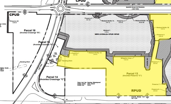
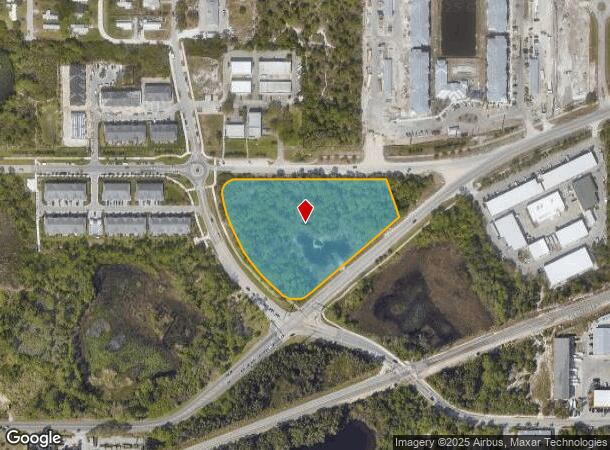
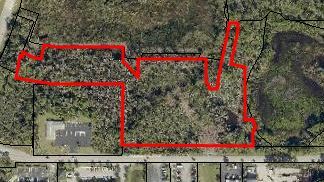
300 Ne Baker Rd
Port St Lucie, FL
New Avonlea
28-37-41-013-000-00100-0
LOT 10 NEW AVONLEA PUD ACCORDING TO THE PLAT THEREOF RECORDED IN PLAT BOOK 17 PAGE 35 PUBLIC RECORDS MARTIN COUNTY FLORIDA
Vacantlandnec
Martin
X
Florida
12085C0151H
10
2024
4.06 AC
2025
Port St Lucie
000701
Port St Lucie/Fort Pierce
DEMOGRAPHICS near 300 Ne Baker Rd
1 Mile
3 Mile
5 Mile
2024 Total Population
4,068
42,899
111,761
2029 Population
4,310
45,582
123,673
Pop Growth 2024-2029
+ 5.95%
+ 6.25%
+ 10.66%
Average Age
47
50
49
2024 Total Households
1,841
20,031
50,267
HH Growth 2024-2029
+ 5.87%
+ 6.24%
+ 10.74%
Median Household Inc
$63,176
$58,704
$65,060
Avg Household Size
2.20
2.00
2.10
2024 Avg HH Vehicles
2.00
2.00
2.00
Median Home Value
$362,121
$321,240
$328,771
Median Year Built
1984
1981
1986
Nearby Places
Map Layers
Map Styles
 Street
 Aerial
- Restaurants
- Banks
- Shops
- Fitness
- Groceries
Nearby Properties
Address
Land Use
TOTAL SIZE
Lot Size
Zoning
Address
Land Use
TOTAL SIZE
Lot Size
Zoning
609,195 SF
13.77 AC
H
Address
Land Use
TOTAL SIZE
Lot Size
Zoning
481,508 SF
59.41 AC
PUDC
Address
Land Use
TOTAL SIZE
Lot Size
Zoning
11.34 AC
Address
Land Use
TOTAL SIZE
Lot Size
Zoning
292,279 SF
65.79 AC
R2
Address
Land Use
TOTAL SIZE
Lot Size
Zoning
309,031 SF
76.74 AC
RPUD
Address
Land Use
TOTAL SIZE
Lot Size
Zoning
378,814 SF
34.25 AC
PUDR
Address
Land Use
TOTAL SIZE
Lot Size
Zoning
14.86 AC
M1
Address
Land Use
TOTAL SIZE
Lot Size
Zoning
6.66 AC
RPUD
Address
Land Use
TOTAL SIZE
Lot Size
Zoning
23.08 AC
RM8
Address
Land Use
TOTAL SIZE
Lot Size
Zoning
9.45 AC
RS6
Address
Land Use
TOTAL SIZE
Lot Size
Zoning
160,211 SF
17.44 AC
CPUD
Address
Land Use
TOTAL SIZE
Lot Size
Zoning
127,238 SF
3.62 AC
P
Address
Land Use
TOTAL SIZE
Lot Size
Zoning
106,357 SF
22.96 AC
Address
Land Use
TOTAL SIZE
Lot Size
Zoning
189,035 SF
20.63 AC
R3
Address
Land Use
TOTAL SIZE
Lot Size
Zoning
196,180 SF
18.71 AC
B1
Address
Land Use
TOTAL SIZE
Lot Size
Zoning
175,170 SF
19.53 AC
B1
Address
Land Use
TOTAL SIZE
Lot Size
Zoning
1,050 SF
5.33 AC
R3
Address
Land Use
TOTAL SIZE
Lot Size
Zoning
23,640 SF
15.28 AC
B2
Address
Land Use
TOTAL SIZE
Lot Size
Zoning
124,082 SF
4.60 AC
P
Address
Land Use
TOTAL SIZE
Lot Size
Zoning
2,221 SF
18.12 AC
R3A
Address
Land Use
TOTAL SIZE
Lot Size
Zoning
2,400 SF
7.31 AC
INDUST
Address
Land Use
TOTAL SIZE
Lot Size
Zoning
116,258 SF
14.58 AC
R3
Address
Land Use
TOTAL SIZE
Lot Size
Zoning
204,538 SF
22.65 AC
P
Address
Land Use
TOTAL SIZE
Lot Size
Zoning
152,826 SF
15 AC
B2
Address
Land Use
TOTAL SIZE
Lot Size
Zoning
198,758 SF
39.92 AC
RM5
Address
Land Use
TOTAL SIZE
Lot Size
Zoning
111,534 SF
11.59 AC
PUDC
Address
Land Use
TOTAL SIZE
Lot Size
Zoning
96,999 SF
11.72 AC
MH
Address
Land Use
TOTAL SIZE
Lot Size
Zoning
52,554 SF
130.53 AC
PUD
Address
Land Use
TOTAL SIZE
Lot Size
Zoning
120,234 SF
4.83 AC
R3
Address
Land Use
TOTAL SIZE
Lot Size
Zoning
77,236 SF
9.11 AC
B1
The World's #1 Commercial Real Estate Marketplace
Connect with us
© 2025 CoStar Group
The information above has been obtained from sources believed reliable. While we do not doubt its accuracy we have not verified it and make no guarantee, warranty or representation about it. It is your responsibility to independently confirm its accuracy and completeness. Any projections, opinions, assumptions, or estimates used are for example only and do not represent the current or future performance of the property. The value of this transaction to you depends on tax and other factors which should be evaluated by your tax, financial, and legal advisors. You and your advisors should conduct a careful, independent investigation of the property to determine to your satisfaction the suitability of the property for your needs.